Dear Florida Climate Center Friends, | |
Happy summer! We'd like to present you with the Spring 2024 edition of our quarterly newsletter. In this newsletter, you'll find our most recent monthly climate summaries for the past 3 months, recent heat and drought trends, the latest El Niño status, and the summer season outlook. You will also find an update on recent events and activities we've been engaged in. If you have any questions, please send us an e-mail at climate@coaps.fsu.edu.
Thanks,
The Staff of the Florida Climate Center
| |
|
Monthly Climate Summaries for Florida | |
The Florida Climate Center's March, April, and May Climate Summaries for Florida are available, as well as previous monthly summaries. These summaries provide an analysis of temperature and precipitation patterns across the state, along with data on hazardous weather, drought, and daily records tied or broken each month.
Monthly average temperatures in March were above normal. The monthly departures from normal ranged from +0.7 ̊F in Pensacola to +4.4 ̊F in Orlando. Central and southern Florida were especially warm; many locations recorded one of their top five warmest months of March on record.
Average temperatures in April were near normal for the month. The monthly mean temperature departures from normal ranged from -0.6 ̊F in Gainesville to +0.9 ̊F in Tallahassee. Mid-month saw a warm spell across much of the state, and some places hit 90+F for the first time this year. The remainder of the month saw milder temperatures.
Average monthly temperatures in May were well above normal. Monthly mean temperature departures from normal ranged from +1.5 ̊F in Pensacola to +5.5 ̊F in West Palm Beach. May 2024 was the warmest May on record statewide, and many stations across central and southern Florida recorded their warmest May on record. Many daily high maximum and high minimum temperature records were set during the month.
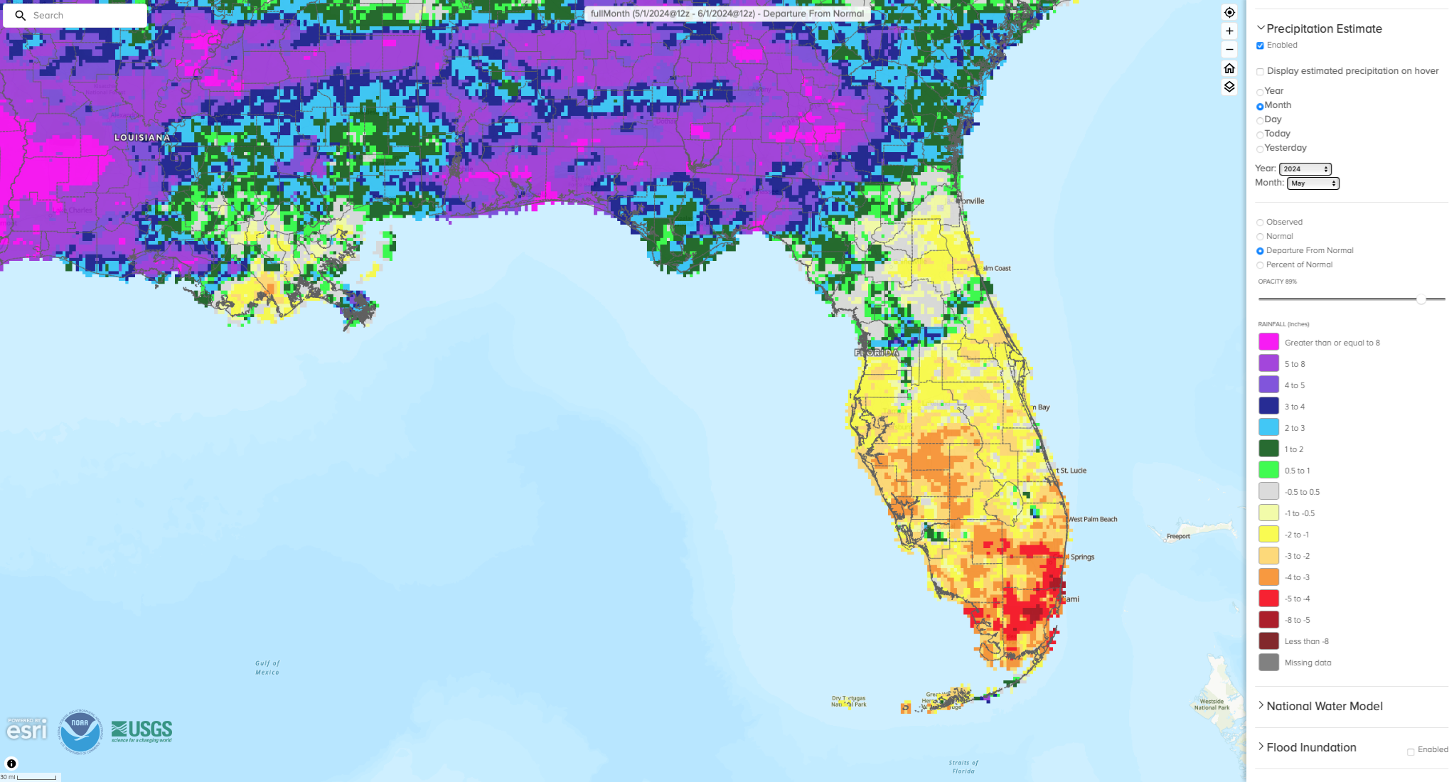
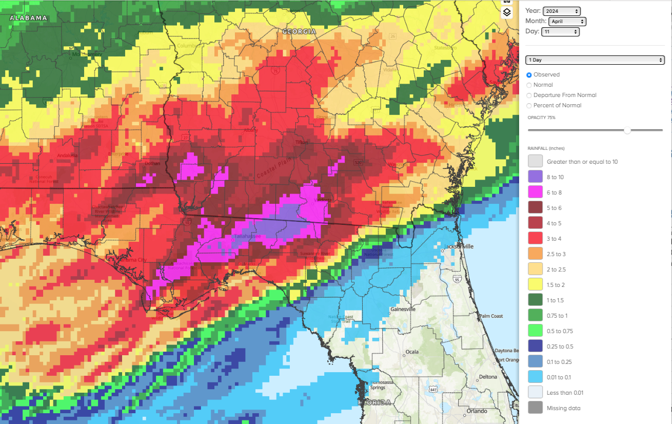
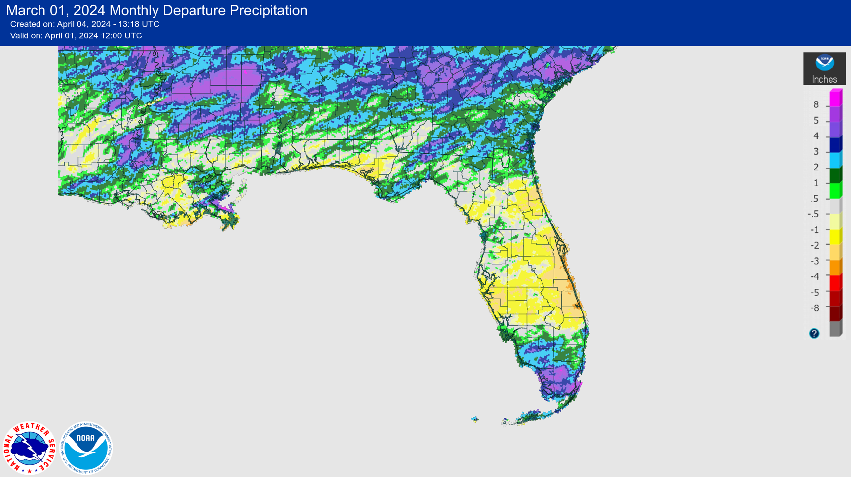
The figures below are graphical depictions of the monthly rainfall departure from normal (in inches) for March, April, and May (courtesy of the National Weather Service), as well as the 3-month seasonal rainfall departure from normal (courtesy of the Midwestern Regional Climate Center).
|  | |
Spring Brought More Record Heat | |
Spring (MAM) mean temperatures were much above average in Florida, at +3.2̊F above average and tying as the 6th-warmest spring on record dating back to 1895.
May 2024 was the hottest May on record for Florida. The statewide average monthly mean temperature for May was 79.6 ̊F, which was 4.5 ̊F above average. The mean monthly temperatures in May were between 3 and 6 degrees F above average for most stations across the state.
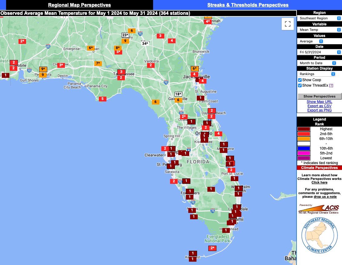
May's heat was especially felt across the Peninsula. The map below shows the station rankings for the month of May, courtesy of the Southeast Regional Climate Center. Stations across the Peninsula that recorded their warmest May on record include Orlando, Tampa, Fort Myers, Sarasota, Melbourne, Daytona Beach, West Palm Beach, Fort Lauderdale, Miami, Naples, Homestead, and Key West.
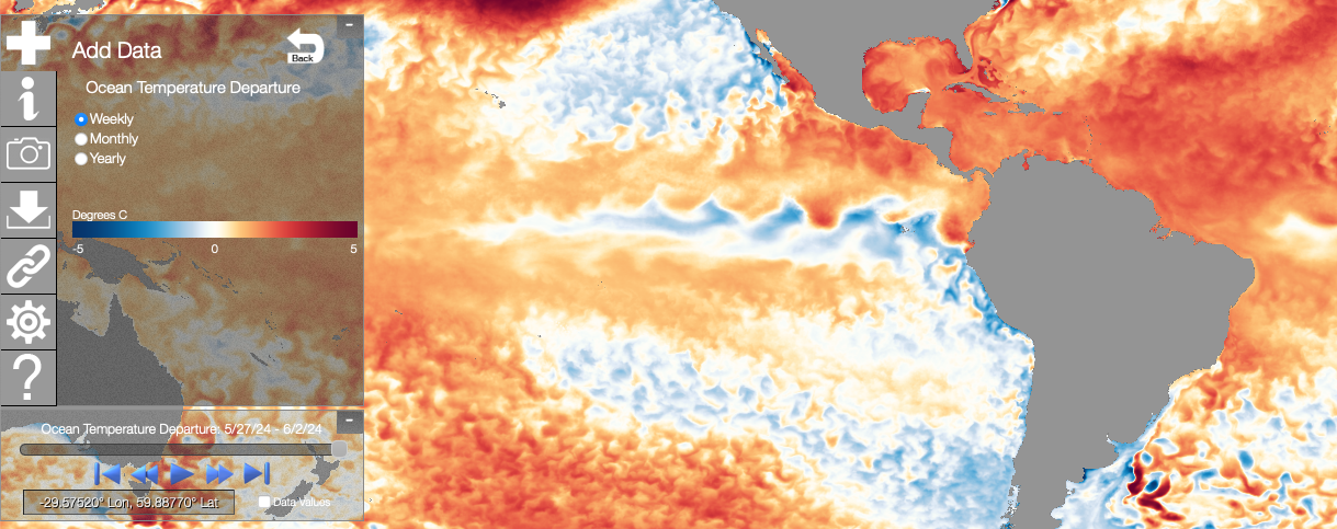
Fort Lauderdale tied its all-time highest minimum temperature of 85 ̊F on the 14th. The Hollywood North Perry Airport reached a maximum temperature of 101 ̊F on the 19th, which is the all-time highest temperature for that station. Punta Gorda reached a maximum temperature of 101 ̊F, which tied for all-time highest maximum temperature dating back to 1914. Record sea surface temperatures in the Caribbean, Gulf of Mexico, and tropical Atlantic Ocean contributed to high heat index values as well. Key West recorded a heat index of 114 ̊F on May 15, which was just shy of its highest value on record (since 1948). On May 18 and 19, Miami recorded a record heat index of 112 ̊F, which was 6 ̊F above the previous May heat index record. All in all, there were 146 daily high maximum and high minimum temperature records set during the month.
|  | |
Tallahassee Heavy Rainfall Event in April and Tornadoes in May | |
|
Heavy rain and multiple severe weather outbreaks impacted Florida this spring. On April 10-11, strong storms moved through the Panhandle producing heavy rain and flash flooding. Tallahassee received 7.11 inches of rain in the overnight hours of April 10-11, which was 96% of their month's total rainfall in just a few hours. The storm led to flooding of roadways and buildings and closed schools.
May had 57 confirmed tornadoes in the Southeast U.S., with 6 of these tornadoes occurring in Florida. The median frequency in May in the Southeast is 11 tornadoes; Florida has an average of 4.6 tornadoes in May (1950-2022).
| |
|
A severe weather outbreak associated with an intense squall line on May 10 spawned 3 tornadoes that moved through Leon County. These included 2 EF-2 tornadoes that moved through Tallahassee and caused extensive damage along their paths, including to the FAMU and FSU campuses. An EF-1 tornado moved through Woodville just south of Tallahassee and was on the ground for 31.7 miles, ranking as the longest track on record for the county since 1945. | |
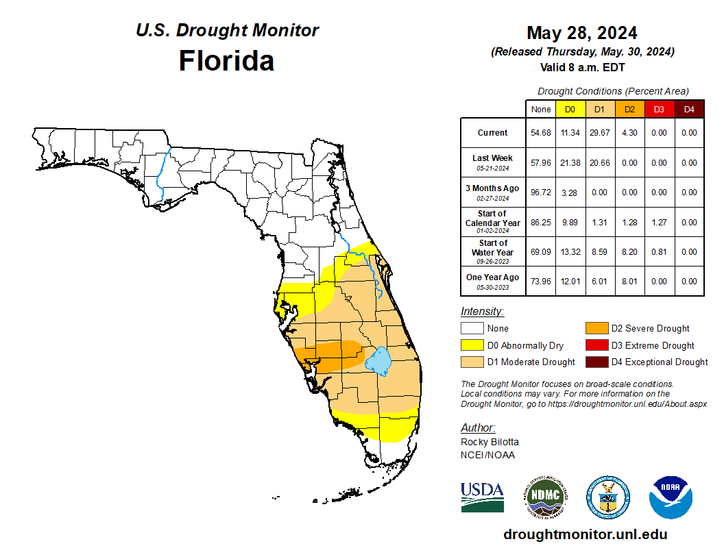
Spring Drought Development
Heavy rainfall in the Panhandle in April and May led to well above normal rainfall. However, the Peninsula experienced below normal rainfall and drying conditions as the season progressed. Drought developed in late April and expanded through May. By the end of May, about 4.3% of the state was in severe drought (D2) and 30% was in moderate drought (D1); 11% was abnormally dry (D0), according to the U.S. Drought Monitor.
Recent heavy rainfall from June 11-14 across South Florida, with rainfall totals between 4 and 18+ inches, has led to drought removal in South Florida.
| |
NOAA Issues Final El Niño Advisory; La Niña Around the Corner | El Niño conditions, the warm phase of the El Niño Southern Oscillation climate pattern in the tropical equatorial Pacific Ocean, continued to weaken over the past couple of months. Near-to-below average sea surface temperature (SST) anomalies expanded across the eastern equatorial Pacific Ocean. Currently, ENSO-neutral conditions are present. La Niña is favored to develop during July-September (65% chance) and persist into the Northern Hemisphere winter 2024-25 (85% chance during November-January). | |
Summer 2024 Leaning Warm and Wet in Florida | The NOAA Climate Prediction Center's outlook for this summer is leaning toward a warmer than normal summer on average, June through August, in Florida and nearly the entire country. Summer precipitation is expected to be above average across Florida. Drought removal is expected as the rainy season gets underway. |
|
Recent Engagements & News | |
FCC Undergraduate Student Presents at the FSU WIMSE Symposium | |
|
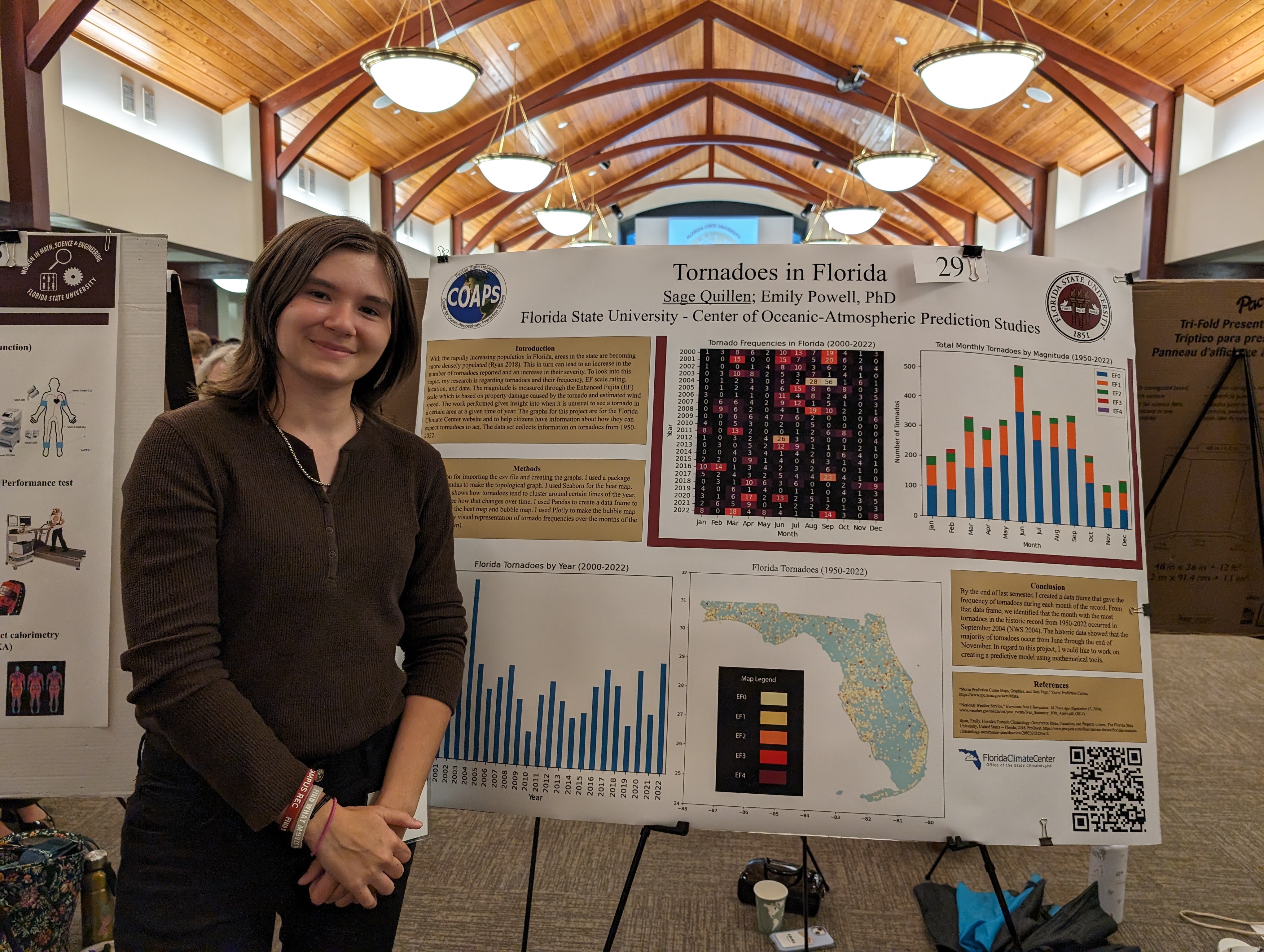
The Florida Climate Center hosted a FSU undergraduate student, Sage Quillen, through the FSU WIMSE program (Women in Math, Science and Engineering) during the 2023-24 academic year. Quillen worked with Dr. Powell to update data and build new tools and visualizations.
During the fall and spring semesters, Quillen updated and created new visualizations of Florida's tornado climatology. This work was presented as a poster at the WIMSE Symposium in March on the FSU campus.
Quillen will continue working this fall on a new tool to provide information on past extreme heat for stations across Florida.
| |
|
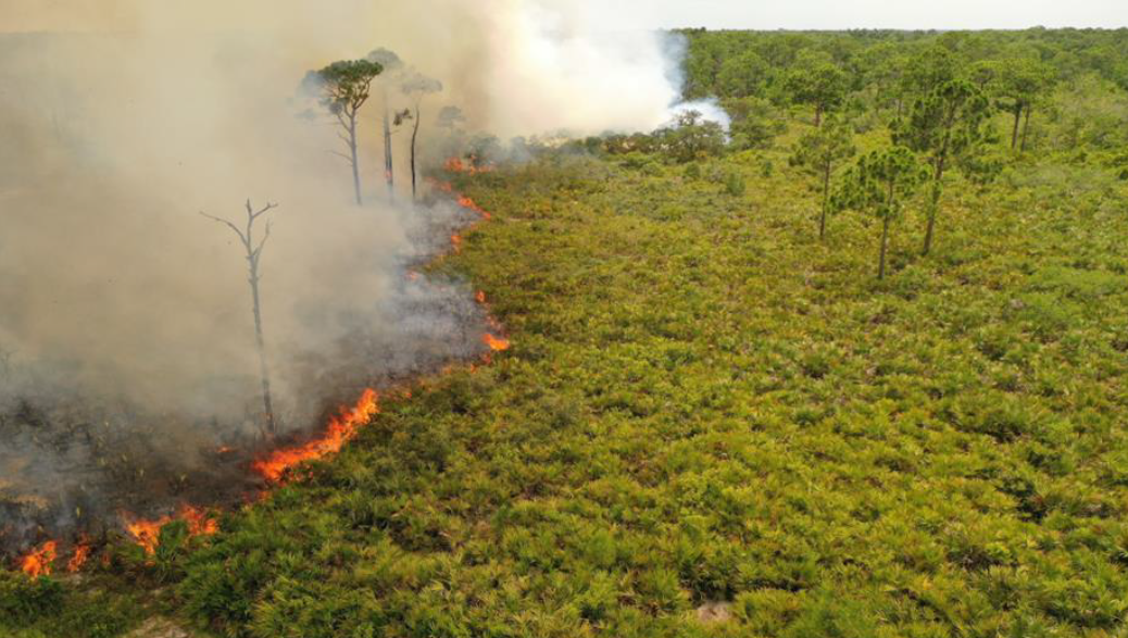
FCC Participates in New Florida Wildlife Corridor Report | |
Florida State University's Center for Ocean-Atmospheric Prediction Studies (COAPS) Co-Hosts Joint Climate Workshop | |
|
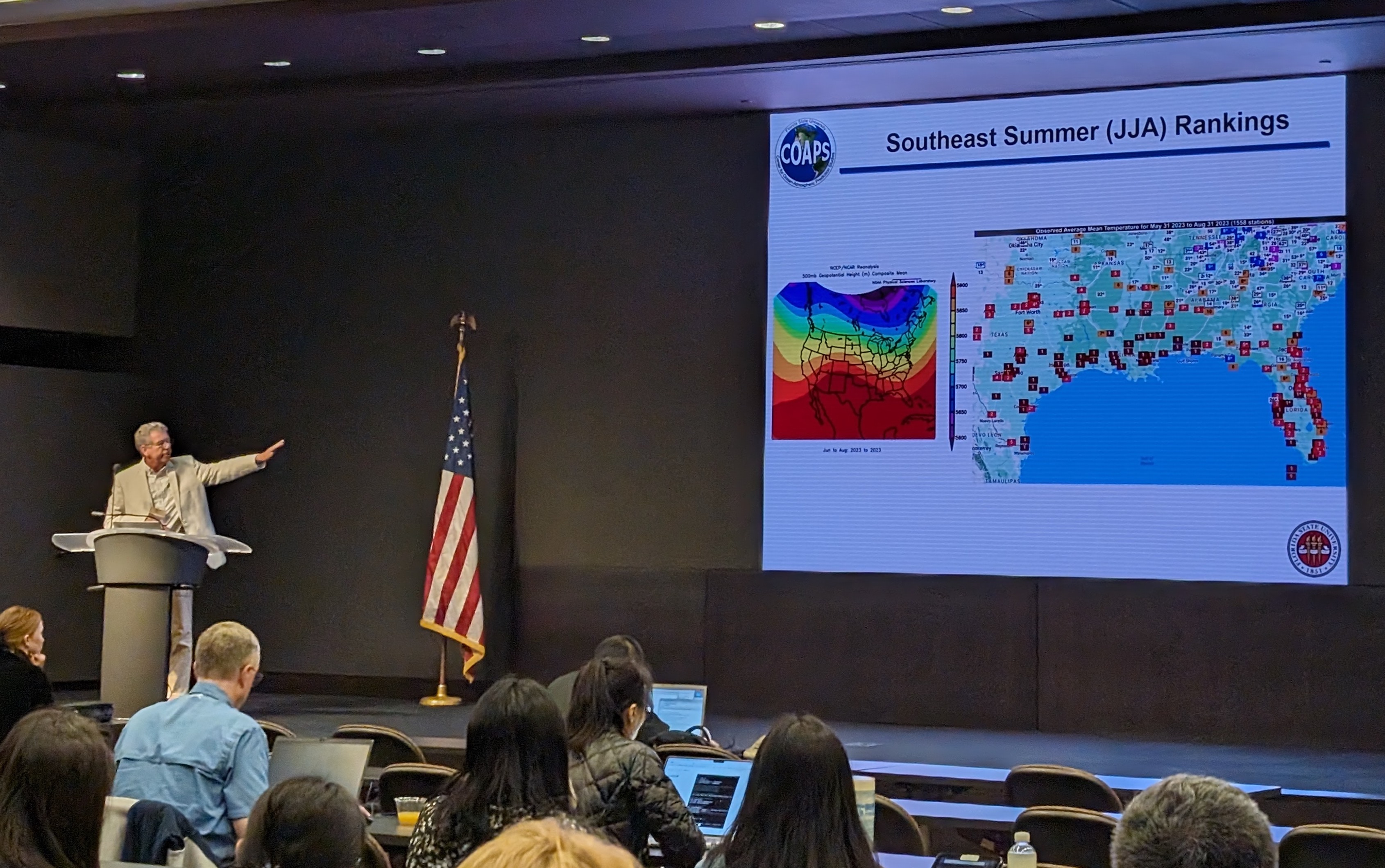
The 48th Climate Diagnostics and Prediction Workshop and 21st Climate Prediction and Applications Science Workshop was held March 26-29 at FSU in Tallahassee, FL.
The event was co-hosted by the FSU Center for Ocean-Atmospheric Prediction Studies and the Department of Earth, Ocean, and Atmospheric Science. State Climatologist David Zierden gave a keynote presentation titled, "Florida Climate Recap: 2023 and Beyond."
| |
|
2024 Southeast Regional Meeting of State Climate Offices | |
The Florida Climate Center's Assistant State Climatologist Dr. Emily Powell attended a regional gathering of state climate offices across the Southeast U.S. in April. Hosted by the Southeast Regional Climate Center and the South Carolina State Climate Office, the group discussed the evolution and future of climate services and delivery in the Southeast. | |
|
|
Southeast Climate Monthly Webinar Series
This webinar series, hosted by the Southeast Regional Climate Center in partnership with the National Integrated Drought Information System (NIDIS) and the NOAA National Weather Service, is held on the 4th Tuesday of each month at 10am ET. The next webinar is June 25, and the special topic is "2024 Atlantic Hurricane Outlook." Register here. These webinars are recorded and available for viewing following each event.
| |
|
The Florida Climate Center is part of a three-tiered system of national, regional, and state climate offices, including NOAA's National Centers for Environmental Information (NCEI - in Asheville, North Carolina) and the Southeast Regional Climate Center (in Chapel Hill, North Carolina). The Florida State Climatologist and staff at the Florida Climate Center provide the following information and services to the people of Florida:
Climate Data
Historical weather observations for weather stations throughout the state of Florida. We are able to provide data for most stations from 1948-present.
Climate Information
Long-term historical averages for various stations, climate divisions, and the entire state.
Extreme Event Records
Information and analyses on extreme events such as freezes, droughts, floods and hurricanes.
Special Analysis
With their vast knowledge of El Niño, La Niña and climate variability, the State Climatologist and staff can offer expert insight into Florida's climate trends.
Outreach
Activities, presentations, and workshops that inform and educate the people of Florida about current and emerging climate issues. We also coordinate volunteers for the Community Collaborative Rain, Hail & Snow Network (CoCoRaHS).
| | | | |