Sonoma Water E-News | August 2024 | |
Stream Maintenance Program in High Gear | |
|
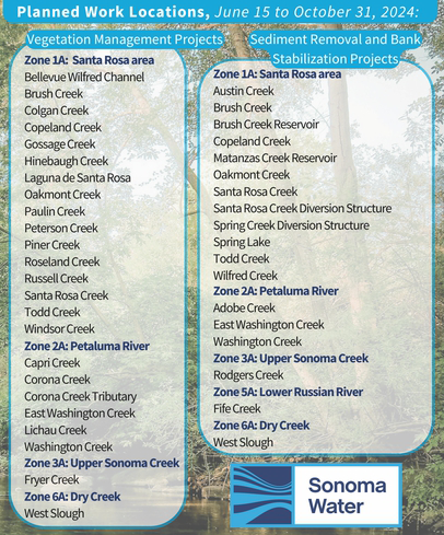
Each summer, from June to October, Sonoma Water works in and around streams and channels throughout Sonoma County as part of the Stream Maintenance Program. Activities occur mainly along flood control channels to provide flood protection, restore habitats and manage vegetation. These enhancements improve water quality, restore fish and wildlife habitats and reduce the risk of flooding.
All of the stream maintenance activities we perform are permitted by both the Regional Water Quality Control Board and the California Department of Fish and Game.
| |
|
Planned work locations for the Stream Maintenance Program this season are listed in this graphic
Pictured above: (top) environmental resources team surveying to protect fish prior to sediment removal.
(bottom) Sediment removal underway near a residential area at Copeland Creek
| |
Looking back over 75 years: The 1970s
| |
|
The 1970s brought new connections to the Bay Area with the construction of US-101. Demand for water grew along with the growth of the county population as new businesses and families moved to the area, with flows through the Santa Rosa Aqueduct increasing 300% from 1960 to 1970. More collectors were needed as were more aqueducts. The 1974 Agreement for Water Supply gave direction to Sonoma Water to operate, maintain and expand the water supply and transmission system.
This meant a new intertie pipeline from the Russian River to Cotati, additional diversion facilities at the Russian River, an inflatable dam at the diversion site to fill infiltration ponds, booster pumps, storage tanks, emergency wells, a hydroelectric plant at Warm Springs Dam, corrosion control facilities, a water quality early warning system and computerized telemetry systems.
| |
The 1974 Agreement for Water Supply fixed the amount of water to be delivered to the water contractors based on their own estimated needs. The signatories to the agreement were the cities of Santa Rosa, Petaluma, Rohnert Park, Sonoma and Cotati; North Marin Water District; Valley of the Moon Water District and Forestville Water District. | |
|
Russian River diversion structure under construction in preparation for the Mirabel inflatable dam installation, c. 1976
| |
 |  | In 1974, under orders from the Federal District Court, the U.S. Army Corps undertook a second, more in-depth cultural research program at the site of the future Warm Springs Dam that found a wide variety of historic cultural resources present in the project area. The study found multiple sites of cultural significance for the local indigenous tribes that are native and live in the area. The study revealed that Pomo tribes still harvested certain types of sedge and willow fibers for weaving baskets in Warm Springs Valley, which would be destroyed by the dam’s construction and subsequent flooding of the reservoir. The creeks here were considered one of the best sources for this kind of sedge by tribes from all over California. As a result of these findings and in response to advocacy by a group of women Pomo elders including acclaimed basket weaver Elsie Allen (pictured here), the Pomo consecrated new sites for these plants and transplanted more than 48,000 sedge onto government-owned land. In addition, 400 herbs of ritual and medicinal significance were also transplanted, and more than 336 cubic meters of soil were excavated by hand and sifted through mesh screens to recover all cultural material.
| |
|
The decade also brought several new federal environmental laws along with the creation of the Environmental Protection Agency, including the National Environmental Policy Act and the Clean Air Act, both of 1970 and the Clean Water Act of 1972. Sonoma Water hired its first environmental specialist in 1974 to prepare environmental documentation, studies and reports required by law.
Beginning in 1974, the first of many lawsuits was filed to stop the construction of the dam for alleged violations of the National Environmental Policy Act, and construction was largely blocked until 1980.
| |
Pictured, above: New sedge sites were consecrated by noted Pomo basket weavers and elders (front row, from left) Laura Somersal, Elsie Allen, Mabel McKay. Assisting were (back row, from left) Prof. David Peri of Sonoma State University who was contractor and principal investigator; Dr. Richard Lerner, anthropologist with the San Francisco District Corps office; Brig. Gen. B. G. Homer Johnstone, South Pacific Division Engineer; and Steven Phelps, Warm Springs Dam-Lake Sonoma park manager. Source: The Warm Springs Dam - Lake Sonoma Project souvenir book, 1983. | |
This is Not Your Grandpa's Landscape | |
|
Gone are the days when sprawling lawns that drank water with reckless abandon were the pride of the neighborhood. Grandpa's idea of a perfect landscape was a lush, green expanse that demanded the blood, sweat, and tears of countless sprinklers and garden hoses. Every morning, as the sun rose, you'd see a symphony of sprinklers spinning in unison, making sure every blade of grass got its fair share of H2O. It was a time when "sustainability" was something you worried about after ensuring your boxwood hedges were shaped just right.
Fast forward to today, and those thirsty landscapes are being transformed into scenes that would make any xeriscaping enthusiast weep with joy. Instead of endless seas of green, we now have native plants that don't just survive but thrive on what Mother Nature provides. Modern landscapes showcase drought-resistant, native, and climate adapted plant choices, ornamental grasses, and wildflowers that thrive despite water restrictions. With the growing awareness of climate change, transforming your landscape to be climate-ready is not just trendy but a necessity. Rain barrels and drip irrigation systems have become the norm, ensuring every precious drop of water is utilized efficiently, while mulch protects soil moisture and reduces the need for those dreaded, resource-sapping watering schedules.
Today's gardens are as functional as they are beautiful, attracting pollinators and providing habitats for local wildlife. They represent a paradigm shift from indulgence to responsibility, from opulence to sustainability. It’s a quiet revolution, one where our yards are not just a reflection of personal pride but a testament to our collective responsibility towards the planet. Grandpa might raise an eyebrow at the sight of your wildflower meadow, but deep down, even he would have to admit that this new era of climate-ready landscaping is truly a cut above.
| |
Teachers, it’s time to book your field trips!
Sonoma Water staff are once again gearing up for a full slate of educational programs that include visiting classrooms, shipping free materials to teachers, supporting the Steelhead in the Classroom program, and hosting students at the Sonoma Water Education Center for engaging programming about the vital role of water and energy in our communities.
Programs are free, hands-on, and aligned with the Next Generation Science Standards. Programs support students in becoming environmental stewards and informed citizens who examine the world through an inquisitive, scientific lens.
Teachers can register for these programs at SonomaWater.org/education.
| |  |
Back to school! Remember to pack a reusable water bottle in your lunch box
Our kids need to stay hydrated while at school, so be sure to make a reusable water bottle one of your back-to-school essentials. Not only ditching single use disposable bottles good for our environment, taking water from the tap in a nifty, personal water bottle is a money saver too! And drinking water rather than sugary drinks is better for kids’ health.
| | |
Webinar to feature new Level Up! Voluntary Well Monitoring Program
Did you know? Sonoma County’s groundwater sustainability agencies are now seeking property owners with wells in the Santa Rosa Plain subbasin, Petaluma Valley basin and Sonoma Valley subbasin to participate in a local voluntary groundwater well monitoring program. Well owners may sign up with some basic information about their well and then, two times a year, in April and October, when water is typically highest and lowest, measure the well water level. Well owners may then submit that information to be included in a new online Sonoma County Groundwater Data Dashboard launching later this summer. Most participants in the program will measure these levels following DIY training but select wells may be included in a facilitated program where trained staff members will take measurements twice a year.
Informational Voluntary Well Monitoring Webinar Monday, Aug. 19, 5-6 p.m.
Register to attend an informational webinar on Monday, Aug. 19, 5-6 p.m. to hear an overview of current groundwater conditions, get a tour of the new Sonoma County Groundwater Data Dashboard, see how the well monitor sounder device works and learn how to submit information to the online portal. If you already track water levels and are interested in submitting data, we will cover that too. These sessions will provide an opportunity for local well owners to ask questions and learn more about the program. If you can’t attend the webinar live, a recording will be available on our website after Aug. 20. Learn more and register for the webinar: sonomacountygroundwater.org/voluntary-monitoring
This program is one of many projects underway in the Groundwater Sustainability Plans for Sonoma County’s three groundwater sustainability agencies in Petaluma Valley, Sonoma Valley and Santa Rosa Plain. These plans were developed over many months with broad input from the community and were approved by the California Department of Water Resources in 2023. The Voluntary Well Monitoring Program is funded through Sustainable Groundwater Management Implementation grants from the State of California awarded in 2023.
| |
|
Current water supply conditions as of 8/12/2024:
Lake Mendocino FIRO* Target Water Storage Curve: 111,000 acre-feet
Current Storage: 80,657 acre-feet (72.66% of FIRO Storage Curve)
Lake Sonoma Minor Deviation Curve: 264,000 acre-feet
Current Storage: 242,570 acre-feet (91.88% of Minor Deviation Storage Curve)
*FIRO is the acronym for Forecast Informed Reservoir Operations
Current rainfall conditions (10/1/23 –8/13/24)
Ukiah:
Current Water Year: 38.15” which is 104% of average
Average (1894-2023 water years): 36.82"
Santa Rosa (STS):
Current Water Year: 35.61” which is 99% of average
Average (1950-2023 water years): 35.86"
Rainfall Data Source: NOAA's California Nevada River Forecast Center
| | |
|
Did you know?
August is Water Quality Month. You might be curious about the water that Sonoma Water distributes. In addition to Sonoma Water’s extensive water quality tests required by the US Environmental Protection Agency, the cities and water districts that contract to receive this water supply also perform individual water quality sampling and tests. You can find links to each of the cities’ and water districts’ water quality web pages to learn more about individual testing and results on this webpage.
| |
|
Upcoming Meetings
Eel-Russian Project Authority Board of Directors
View the agenda and video recording of the March 19 Eel-Russian Project Authority Board of Directors Meeting.
For more information visit eelrussianauthority.org/events.
Sonoma Water Board of Directors Meetings
The Sonoma Water Board normally holds its regular meetings on Tuesdays, beginning at 8:30 a.m. and will be facilitated virtually through Zoom and at Board of Supervisors Chambers (BSC) 575 Administration Drive 102A.
•Aug 16 BSC/Virtual/Special Closed Session
•Aug 20 BSC/Virtual
•Aug 28 BSC/Virtual/Special Closed Session-Dept Head Workplans
•Aug 29 BSC/Virtual/Special Closed Session-Dept Head Workplans
•Aug 30 BSC/Virtual/Special Closed Session-Dept Head Workplans
•Sept 10 BSC/Virtual
•Sept 17 BSC/Virtual
•Sept 24 BSC/Virtual
Board Agendas:
View upcoming Agenda items
| | |
| |
Sonoma Water | 404 Aviation Blvd, Santa Rosa, CA 95403 | SonomaWater.org | | | | |