|
CoCoRaHS
FLORIDA
A Community Collaborative
Rain, Hail & Snow Network
| |
|
Winter 2023-24 Newsletter | |
Greetings from the Coordinators, | |
|
We are pleased to present the winter 2023-2024 quarterly newsletter. This winter was dominated by a classically behaved El Niño in the Pacific Ocean, driving an active, wet, and cloudy pattern here in Florida. With ample seasonal rainfall across the state, drought virtually disappeared by the end of February. Cloudy and wet conditions also meant that monthly average temperatures were closer to normal during December, January, and February. This El Niño was considered a strong event. Currently, El Niño conditions are beginning to weaken, however, and a transition to ENSO-neutral conditions is on the horizon, though its influence on our weather could continue for a little while longer.
In this newsletter, we discuss precipitation trends over the past few months, the influence that El Niño has had on our winter weather, and see what the seasonal outlook has in store for the months ahead. We also share highlights from the network. This month also kicked off our annual national recruiting contest to increase the number of volunteer observers in each state!
Your contributions to this network provide important high-density data that help to capture the high spatial variability of our rainfall, as well as important significant weather. Thank you for your continued support and dedication to the CoCoRaHS program.
Sincerely,
Emily Powell
epowell@coaps.fsu.edu
Ivetta Abramyan
ivetta.abramyan@fscj.edu
| |
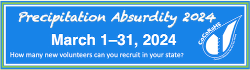
Precipitation Absurdity 2024!
Each year, CoCoRaHS holds a friendly national recruiting contest to see which state can recruit the most new volunteers during the month of March. This year, CoCoRaHS has decided to re-name its annual recruiting contest to "Precipitation Absurdity." Besides the name, everything else about the competition this year is the same.
| |
|
There is always a need for more weather observations. As the saying goes, "the rain doesn't fall the same on all". Due to the variability of precipitation, amounts measured can be quite different only a block or two away.
Help fill in the gaps by recruiting a friend, relative, or neighbor during our recruiting contest this month! The more observations, the clearer the picture, and the better the understanding of where it did and did not rain.
The contest is broken down into 2 categories:
- "Traditional Count" - the state that recruits the greatest overall number of new observers in March.
- "Per Capita" (or population-weighted) - the state that recruits the greatest number of new observers per one million of its total population.
The winning state in each category receives the "CoCoRaHS Cup" to keep and exhibit for a year until next year's contest (in the tradition of the NHL's Stanley Cup). The cup usually travels around the state during the year.
You can view current standings at this link: https://cocorahs.org/marchmadness.aspx.
| |
A Wet and Stormy Winter, Courtesy of El Niño
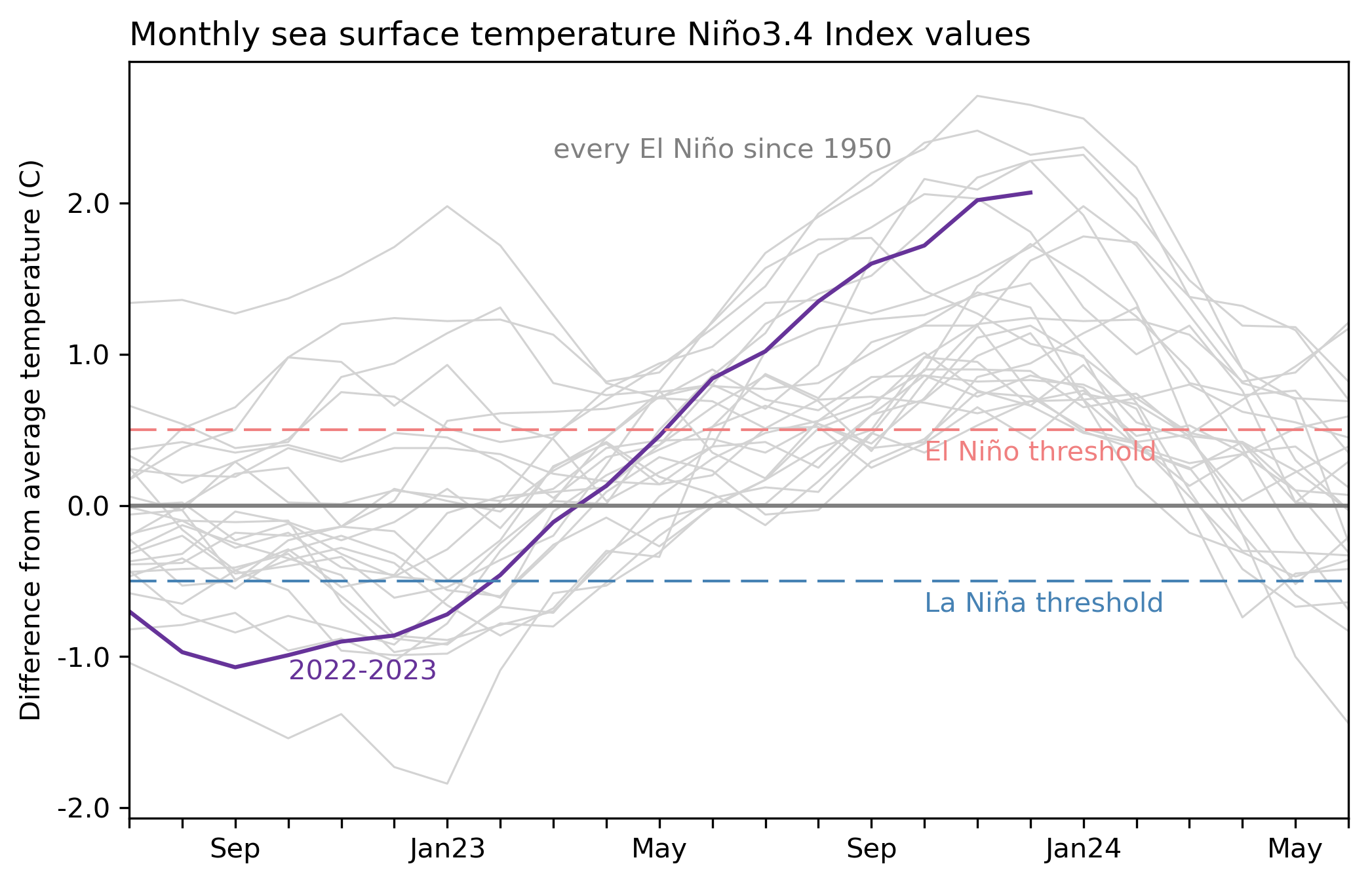
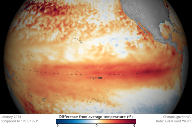
This winter turned out to be a very 'typical' and impactful El Niño event here in Florida. El Niño conditions in the tropical Pacific Ocean persisted and strengthened into a strong event through the winter months. This El Niño will rank as the 5th-strongest on record since 1950 based on November-January period, reaching a sea surface temperature (SST) Nino-3.4 index value of +2.0ºC. Winter (DJF) was wet, cloudy, and stormy across the state, and December-January 2023-24 became the cloudiest winter on record for the Florida Peninsula, based on an 84-year period!
| |
|
During fall, North Florida saw a streak of around 30 consecutive days without measurable rainfall during October-November, which was indicative of delayed El Niño rainfall. Flash drought developed in the western Panhandle in November. By December, however, El Niño rainfall kicked in with more frequent rainfall from December-February; some places had as many as 30 days or more with measurable rainfall during this period.
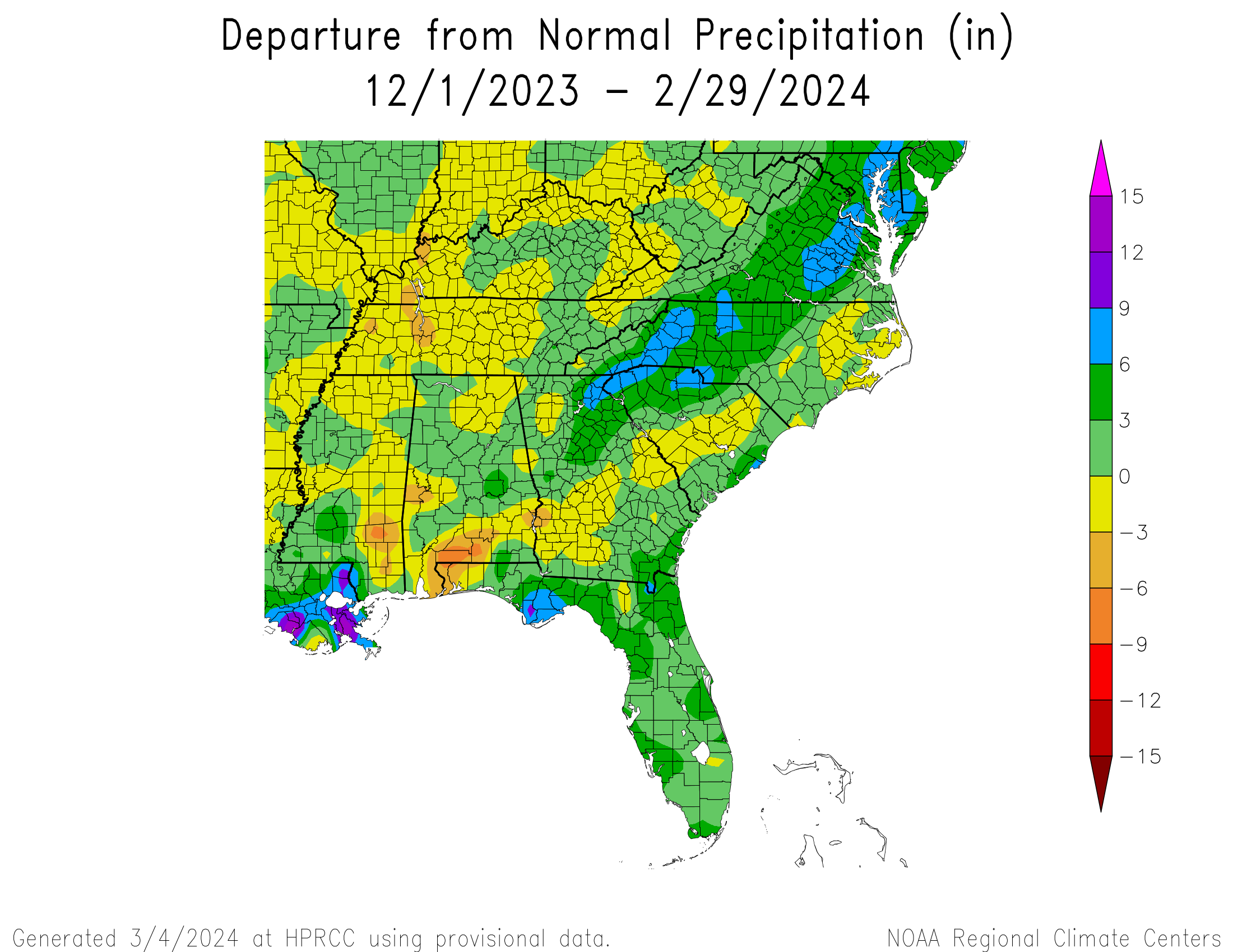
Statewide average precipitation this winter was above normal. The map below shows the rainfall departure from normal, from December 1, 2023 to February 29, 2024, which combines various station network data, including CoCoRaHS, courtesy of the High Plains Regional Climate Center. Some areas received 4-6+ inches of surplus rainfall, and several stations recorded one of their top 5 wettest winters on record: Key West (4th-wettest winter on record based on 72 years), Fort Myers (5th-wettest based on 98 years), and Apalachicola (5th-wettest winter on record based on 80 years). By the end of February, stream flows were running normal to above normal across the state, and drought has virtually disappeared.
| |
|
Severe Weather
Severe weather reports since January 1 show a cluster of tornado and severe wind reports in the Panhandle and Southeast Florida. A few notable storms occurred during the past few months:
- A no-named Gulf low on December 17 produced strong, damaging winds and 3-5 feet of storm surge along Florida's Gulf coast and up through the Carolinas. Heavy rain was reported in north-central and northeast Florida with 5-6+ inches.
- A powerful storm system and squall line moved through the region on January 9 and impacted the Panhandle and North Florida. While not a heavy rainmaker, there were several reports of tornadoes, including an EF3 tornado and two EF2 tornadoes confirmed in Bay County and an EF2 in Jackson County. Wind gusts of 100+ mph were reported in Santa Rosa and Walton Counties. The storm caused at least 9 injuries.
- Another powerful storm system came ashore near Apalachicola on February 4 bringing storms, tornadoes, and heavy rain.
| |
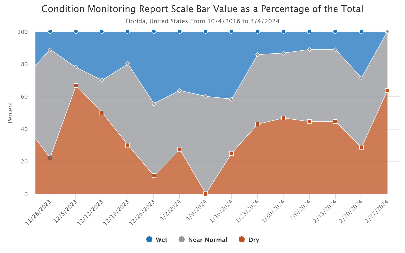
Many of our observers saw wetter or near normal conditions as precipitation totals began to accumulate throughout the season. There were some reports of mildly to moderately dry conditions as some areas were slow to catch up to normal conditions following fall rainfall deficits. This graph below shows the percentage of condition monitoring reports indicating dry, wet, or near normal conditions that were submitted by CoCoRaHS observers in Florida between late November through the end of February. | |
Fall Extremes Across Florida CoCoRaHS
Between 1 December 2023 and 29 February 2024:
- Highest seasonal rainfall total: 26.13" at Wewahitchka, Gulf Co. (GF-7)
- Lowest seasonal rainfall total: 6.14" at Winter Haven, Polk Co. (PK-96)
- Highest daily rainfall total: 9.55" on January 16 at Cape Coral, Lee Co. (LE-78)
*based on data with at least 90% completeness
| |
Significant Weather Reports
Between 1 December 2023 and 29 February 2024, there were:
- 25 total Significant Weather reports submitted.
- 9 reports of Minor flooding.
- 4 reports of Unusual flooding.
| |
Observer Comment Corner
Observer comments are encouraged! Thanks to the many who regularly post comments with their reports. Comments provide valuable context to observations, which can be very helpful to those who later use the observations. If nothing else, comments are interesting for us and other observers to read. Here are only a select few of the comments shared during the past few months. We’ll continue to share your comments in these newsletters.
1. 17 December, Ormond Beach, Volusia County (VL-5) – 4.67 inches
"Light rain began about noon and gradually became moderate. By 1740 0.65" had fallen. Moderate rain became heavy and persistent overnight with an additional 4.02" in dry conditions at 0800 this AM. Total as of 0800 = 4.67". Very windy with a few breaks in clouds. No thunder ocurred."
2. 10 January, Inverness 4.7 WNW, Charlotte County (CT-35) - 1.07 inches:
"Quite the day yesterday. Wind gusts to 53 and very warm. The squall line came thru around 2:30 and contained heavy downpours, some lightning and thunder. Tornado warnings stretched from the Panhandle down to Clearwater. Today is starting out chilly but clear."
3. 16 January, Port St. Lucie 1.8 SW, St. Lucie County (SL-50) - 4.34 inches:
“Very strong thunderstorm in evening, very high rain rates, gusty winds and even a few hailstones. Roads completely underwater after the storm. Rain lasted about hour and half and this measurement is likely under estimated a tad because of winds. Tornado warned 3 times with 2 spotted on the ground few miles to the SE and S of station."
4. 5 February, Gainesville 2.4 SW, Alachua County (AL-50) - 0.21 inches:
"Pea size hail for about 1 minute at 3:00 PM."
5. 5 February, Orange Park 4.1 WSW, Clay County (CY-25) - 0.33 inches:
"Mostly cloudy and calm. Wet. Yesterday rain. Possible tornado approx. 2 miles west of this location in the late afternoon while under a second tornado warning."
6. 19 February, Deerfield Beach 1.7 E, Broward County (BW-167) - 5.12 inches:
“Moderate rain for much of the day yesterday. At reading 62 F. overcast with gentle NW breeze. May have had unusual street flooding, but did not go out to areas subject to such flooding. Interim time/total accumulations by that time: 4 PM, 2.97"; 8 PM 3.91."
| |
NOAA Issues La Niña Watch; El Niño Advisory Remains
El Niño conditions, the warm phase of the El Niño Southern Oscillation climate pattern in the tropical equatorial Pacific Ocean, continued through February. However, SST anomalies and area-averaged subsurface temperature anomalies have begun to weaken in the eastern and east-central Pacific. Atmospheric anomalies across the topical Pacific Ocean also weakened. A transition to ENSO-neutral conditions is expected during April-June 2024 (79% chance).
Strong El Niño events in the past were followed by a rapid transition to La Niña conditions the following summer. It is looking likely that this will happen again this year. Recent forecasts now indicate we are in an El Niño Advisory and a La Niña watch at the same time. There is currently a 55% chance of a transition to La Niña during June-August 2024.
| |
Early Indicators for an Active 2024 Atlantic Hurricane Season
While no official forecasts have been issued for the 2024 Atlantic Basin hurricane season yet, there are indicators that suggest this year could end up being another active year. The prospect of La Niña conditions developing and being in place during the time of peak hurricane season is increasing. In addition, sea surface temperatures in the Atlantic Ocean are extremely warm and even warmer than last year. These factors are conducive to the formation and intensification of tropical cyclones, but it is too early to forecast how other factors will develop that can have a dampening effect on tropical cyclone activity. NOAA and Colorado State University's hurricane season forecasts will be issued later this spring, but early predictions suggest that these forecasts may call for an above-average season.
| |
Spring 2024 Leaning Wetter than Normal in Florida with Temperatures Less Certain
The NOAA Climate Prediction Center's outlook for this spring is leaning toward a wetter than normal spring on average, March through May, for Florida as El Niño continues to influence our seasonal weather patterns. The spring temperature outlook is less certain, with equal chances of being above, below, or near normal. Drought is not expected to impact the state.
| |
|
CoCoRaHS Data Explorer
CoCoRaHS launched a new Data Explorer. This free and user-friendly tool was designed for observers to provide meaningful and ready access to their data, making it easier to visualize and explore precipitation data from your own location as well as data from across the network. Users have options to plot graphs, calendars, distributions, make comparisons to climatology, and much more. The Data Explorer was developed by the CoCoRaHS Headquarters team at CSU, with support from NOAA's Office of Education and CoCoRaHS volunteers.
Access the Data Explorer. Learn more about how to use the data explorer through the training tutorials.
| |
|
Don't Miss Upcoming CoCoRaHS WeatherTalk Webinars!
These webinars take place bi-monthly as one-hour interactive webinar sessions featuring engaging experts in the fields of atmospheric science, climatology and other pertinent disciplines. These easy-to-follow presentations are live and the audience is given the chance to submit questions which the presenter answers live during the webinar.
The next talk is March 14, 2024 at 1PM EDT on how to become a meteorologist. Register and view recordings of past webinars at: https://www.cocorahs.org/Content.aspx?page=wxtalk.
| | | | |