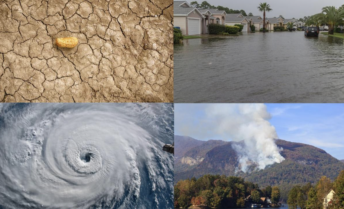
Dear Florida Climate Center Friends, | |
We'd like to present you with the Fall 2023 edition of our quarterly newsletter. In this newsletter, you'll find our most recent monthly climate summaries for the past 3 months, an update on El Niño and the drought status, a recap of the 2023 Atlantic hurricane season, the chances of 2023 becoming the warmest year on record, as well as what to expect this winter. You will also find an update on recent events and activities we've been engaged in. If you have any questions, please send us an e-mail at climate@coaps.fsu.edu.
As we head into the holiday season and new year, we'd like to wish you a very happy holidays!
Thanks,
The Staff of the Florida Climate Center
| |
|
Monthly Climate Summaries for Florida | |
The Florida Climate Center's September, October, and November Climate Summaries for Florida are available, as well as previous monthly summaries. These summaries provide an analysis of temperature and precipitation patterns across the state, along with data on hazardous weather, drought, and daily records tied or broken each month.
Monthly average temperatures in September were above normal across the state, though more tempered following record-breaking summer heat. The monthly departures from normal in September ranged from -0.5 ̊F in Jacksonville to +2.3 ̊F in Naples. September 2023 ranked as the 11th warmest September on record based on statewide monthly average temperatures.
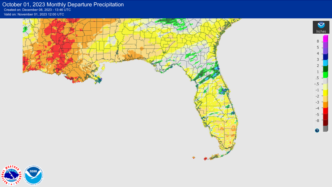
Average temperatures in October were near normal for the month across the state with wide variations in temperature throughout the month. The monthly mean temperature departures from normal ranged from -0.8 ̊F in Jacksonville to +1.9 ̊F in Miami. The month began and ended with above normal temperatures, but a cold front mid-month brought well below normal temperatures across the state.
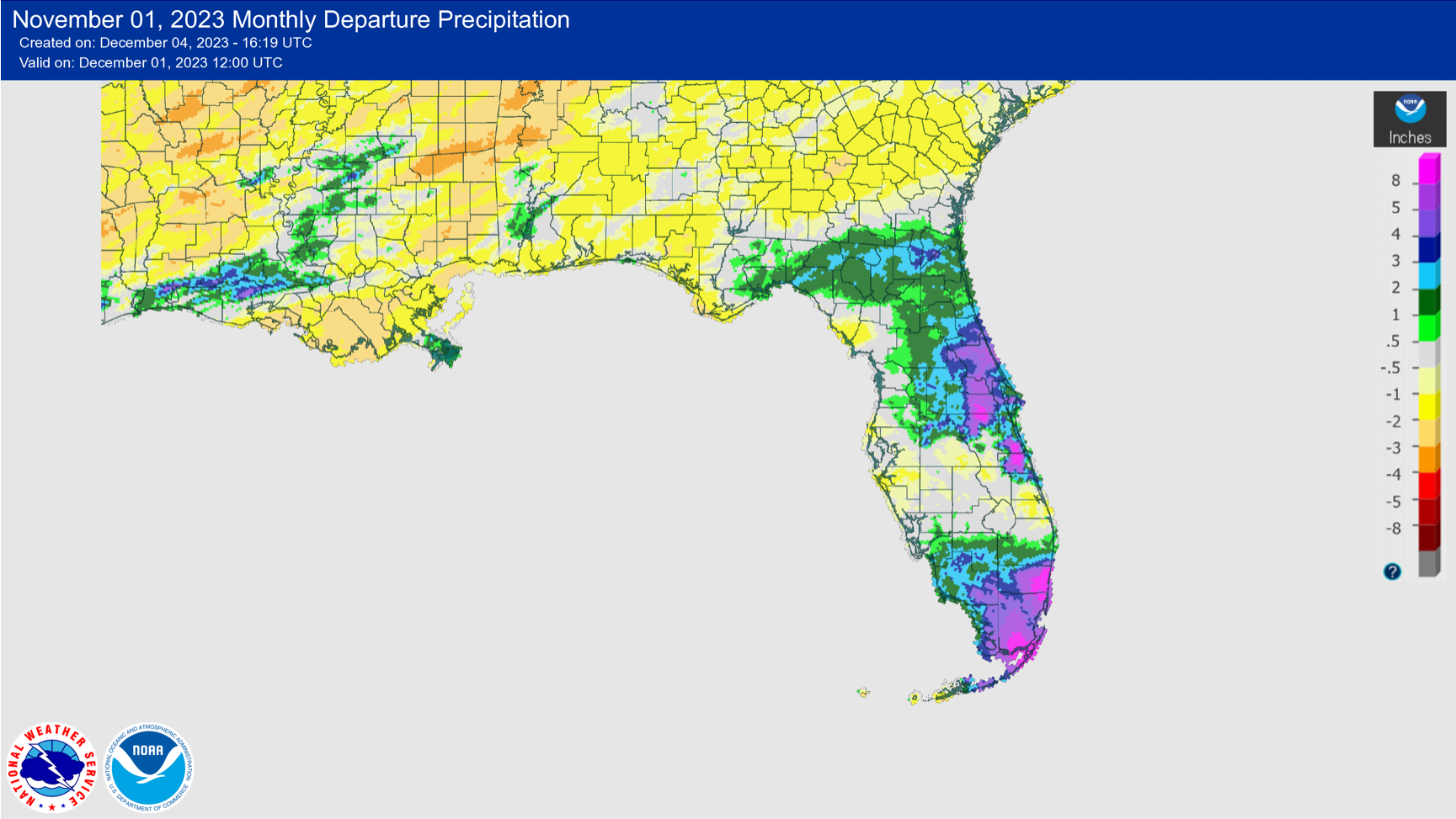
Average monthly temperatures in November were near to above normal. Monthly mean temperature departures from normal ranged from -0.7 ̊F in Jacksonville to +3.0 ̊F in Miami. North Florida saw freezing temperatures late in the month, with 20s across much of the Panhandle including Tallahassee and low 30s in Jacksonville. The probability of the first freeze of the season happening in late November in North Florida is about 50% according to climatology.
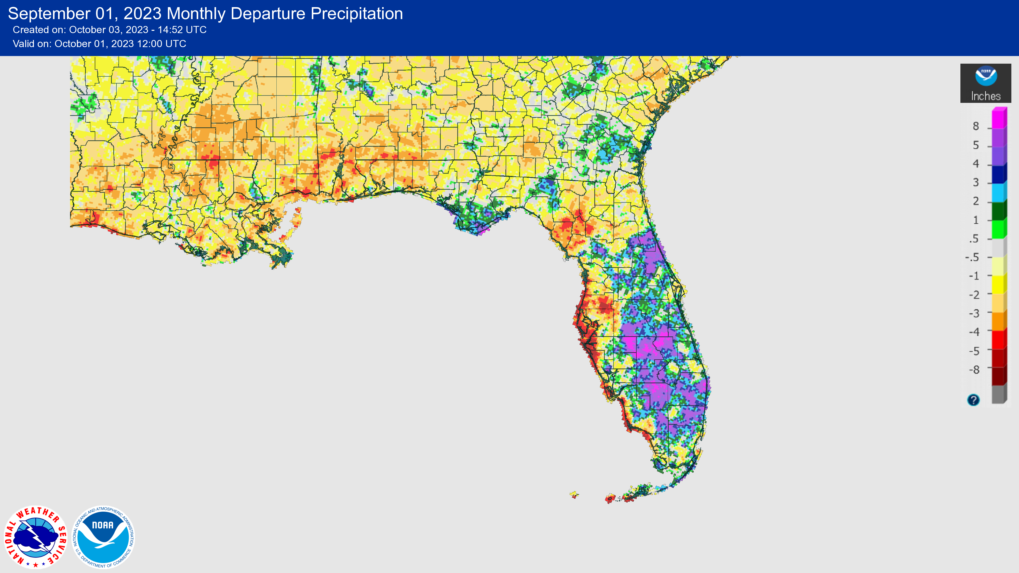
The figures below are graphical depictions of the monthly rainfall departure from normal (in inches) for September, October, and November (courtesy of the National Weather Service), as well as the 3-month seasonal rainfall departure from normal (courtesy of the Midwestern Regional Climate Center).
|  | |
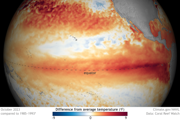
Sea Surface Temperature Anomalies Indicative of a "Strong" El Niño Event | El Niño, the warm phase of the El Niño-Southern Oscillation, has continued to strengthen in the equatorial Pacific Ocean and is expected to persist into the Northern Hemisphere spring with a 62% chance during April-June 2024. Above-average sea surface temperature anomalies across the equatorial Pacific Ocean are indicative of a strong El Niño, with a 55% or greater chance of at least a strong El Niño event (≥ 1.5°C for a seasonal average) and a 35% chance of a "historically strong" (≥ 2.0°C) event for the November-January season. | |
Drought Status in Florida: Too Much Rain or Not Enough | |
Depending on where in Florida you live, it has likely been too wet or too dry this year. Drought affected the western Panhandle and west coast of Florida this fall, while eastern Florida has seen much above normal rainfall (shown on the map of 3-month precipitation departures above). Drought conditions in west coastal Florida persisted through the rainy season and with the rainy season officially over, Florida's west coast is heading into the dry season below normal and new water restrictions have gone into effect for most western coastal counties.
A main driver of this dry-wet pattern across the state has been a weak high pressure system in the western Atlantic Ocean, which affected Atlantic tropical cyclone activity as well as summer rainfall patterns. The east coast has seen extreme rainfall throughout the year, including the record-breaking April storm in Fort Lauderdale, a stormy and active weather pattern in summer, and a mid-November storm that brought 7-13 inches of rain across the southeast and the Keys. Meanwhile, weaker trade winds meant that the western half of the Peninsula missed out on typical summer thunderstorm activity, with only 50%-70% of normal precipitation collected since July 1st.
According to the latest U.S. Drought Monitor map, 1.3% of the state is in Extreme Drought (D3), 1.3% is in Severe Drought (D2), 11% is in Moderate Drought (D1), and 8% is Abnormally Dry (D0). El Niño is expected to bring above normal precipitation to Florida this winter, with drought removal expected during December-February.
|  | |
2023 Atlantic Hurricane Season Ends Above Average Overall |  | |
This year's Atlantic basin hurricane season was above average overall, with 20 named storms (Arlene through Tammy) plus the early season unnamed storm. This included 7 hurricanes and 3 major hurricanes. 2023 ranks 4th for the most named storms on record (tied with 1933), coming in behind 2020 (30 named storms), 2005 (28 named storms), and 2021 (21 named storms).
Based on the 1991-2020 normals, we can expect to have 14 named storms, 7 hurricanes, and 3 major hurricanes in a typical season. So while the season was average for number of hurricanes, it was above average for the total number of named storms as well as accumulated cyclone energy (or ACE), which was 146 compared to an average of 123.
A few things that stood out about this hurricane season:
- Two competing factors played a role in tropical activity this season: the developing El Niño and basin-wide record warm ocean temperatures. Ocean temperatures ended up exerting a greater influence.
- Two early season tropical storms - Bret and Cindy - formed in the main development region of the tropical Atlantic in June, which is unusual for storms to develop that early in the season in this part of the Atlantic.
- There was only one U.S. landfalling hurricane this year (Hurricane Idalia), due to a weak Azores High that helped to steer storms in the Atlantic northward before reaching the U.S. or Caribbean.
-
Hurricane Idalia (a category 3 storm) was the most impactful storm of the season and the only storm to directly impact Florida and the U.S. This part of Florida had not been directly hit by a major hurricane in more than 120 years, since 1896. Read our Hurricane Idalia post-storm summary here.
- Hurricane Lee rapidly intensified by 85 mph in 24 hours, becoming the only category 5 hurricane this year in the Atlantic basin.
| |
2023 on Track to be Hottest Year on Record Globally, How Does Florida Compare? | |
Currently, 2016 has held the title of warmest year on record globally based on a 174-year observational record. 2023 is "virtually certain" to surpass 2016 and become the warmest year on record, according to the World Meteorological Organization, NOAA, and other centers that track global average temperatures.
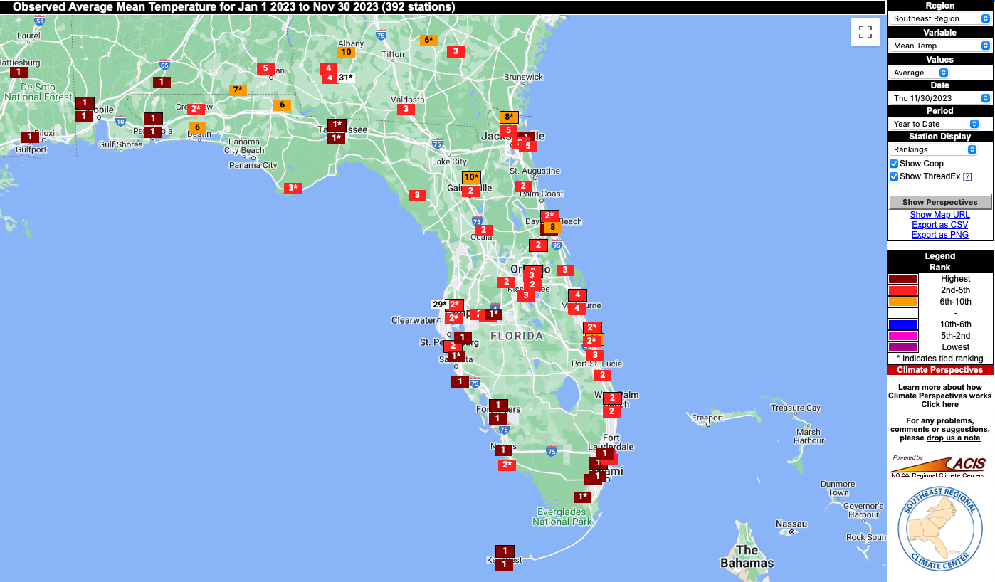
Florida's warmest year on record is 2015, dating back to 1895, which had a statewide average mean temperature of 73.4°F. Based on year-to-date average temperatures through the month of October, Florida as a whole has been running record warm, but just barely by 0.1°F. Station year-to-date rankings through the month of November show that 2023 is on pace to be first or second warmest on record for many. The warmest areas have been the western Panhandle and Southwest Florida. Places likely to see a record warm year this year include Pensacola, Tallahassee, Fort Myers, Miami, and Key West. However, a cool December could derail the chance of 2023 setting a statewide record.
| |
Seasonal Outlook for Winter 2023-24 Heavily Leaning Wetter than Normal in Florida with Temperatures Less Certain | The NOAA Climate Prediction Center's outlook for this winter leans heavily toward a wetter than normal winter on average, December through February, for Florida but there is less certainty in temperatures. Average winter temperatures have equal chances of being above, below, or near normal, while winter precipitation has a 60%-70% chance of being above normal. The strengthening El Niño event is the driving factor behind a wetter winter for Florida and the Southeast U.S. As a result, drought removal is expected in Florida during December-February. | |
|
Lee could approach Category 5 hurricane strength in record-warm Atlantic – WSVN, September 6, 2023
DeSantis betrays Florida, insists the solution to climate change is burning more fossil fuel - Florida Phoenix, September 28, 2023
El Niño in Florida can mean rainy, cool dry season, but climate change may blunt the chill - The Palm Beach Post, October 23, 2023
Ag Man, Woman and Influencer of the year named at Ag Appreciation Luncheon - The Post-Searchlight, November 10, 2023
Will 2023 be Orlando's hottest year on record? It's a nail-biting race to the finish - Orlando Sentinel, December 1, 2023
| |
Recent Engagements & News | |
|
Special ACF and ACT River Basin Drought Webinar
Florida State Climatologist David Zierden participated in a special drought webinar for the Apalachicola-Chattahoochee-Flint (ACF) and the Alabama-Coosa-Tallapoosa (ACT) River Basins. The webinar was held November 15, 2023. Zierden presented on the ACF Basin drought, climate conditions, and future outlook. A recording of the webinar is available here.
| |
|
|
Northwest Florida Regional Resilience Virtual Seminar
On November 3, Florida State Climatologist David Zierden participated in the Northwest Florida Regional Resilience virtual seminar, hosted by Escambia County, Resiliency Florida and WSP, which promoted discussions on resilience activities in the region. Zierden gave an opening presentation on the latest trends in the weather.
| |
|
9th Annual UF Climate Communications Summit
The Florida Climate Center will once again be participating in the annual Climate Communications Summit hosted by the University of Florida. The topic this year will be on Science, Attribution and the Climate Story. Many leading scientsts and communicators will be speaking. Learn more here.
| |
|
Southeast Climate Monthly Webinar Series
This webinar series, hosted by the Southeast Regional Climate Center in partnership with the National Integrated Drought Information System (NIDIS) and the NOAA National Weather Service, is held on the 4th Tuesday of each month at 10am ET. The next webinar is January 23, 2024. The special topic is a 2023 Year in Review. Register here.
| |
|
The Florida Climate Center is part of a three-tiered system of national, regional, and state climate offices, including NOAA's National Centers for Environmental Information (NCEI - in Asheville, North Carolina) and the Southeast Regional Climate Center (in Chapel Hill, North Carolina). The Florida State Climatologist and staff at the Florida Climate Center provide the following information and services to the people of Florida:
Climate Data
Historical weather observations for weather stations throughout the state of Florida. We are able to provide data for most stations from 1948-present.
Climate Information
Long-term historical averages for various stations, climate divisions, and the entire state.
Extreme Event Records
Information and analyses on extreme events such as freezes, droughts, floods and hurricanes.
Special Analysis
With their vast knowledge of El Niño, La Niña and climate variability, the State Climatologist and staff can offer expert insight into Florida's climate trends.
Outreach
Activities, presentations, and workshops that inform and educate the people of Florida about current and emerging climate issues. We also coordinate volunteers for the Community Collaborative Rain, Hail & Snow Network (CoCoRaHS).
| | | | |