Retroreflectivity - shining a light on signs |
|
The ability to see stop signs and other traffic signs at night is something most travelers take for granted, until one of those signs becomes hard to see. This week, staff from LUT’s Traffic Engineering Division are inspecting traffic safety and other County road signs after dark.
In addition to signs’ general condition and visibility, inspectors are checking retroreflectivity – the ability of signs to reflect light. These inspections are required by the U.S. Department of Transportation Federal Highway Administration (FHWA).
Most traffic signs in Washington County are made of microprismatic sheeting, which redirects light back to its original source. The result is that road signs seem to illuminate when they are picked up in headlights. But over time, constant sunlight, moss and other factors cause the sheeting to degrade.
In addition to retroreflectivity, the nighttime inspections also provide inspectors with an opportunity to conduct sign inventories, check condition and general visibility. To report damaged signs, file an online service request.
|
|
-
Gaston Road, between Highway 47 and Spring Hill Road, through Feb. 24 (extended) for bridge replacement. Detour map
|
|
-
Kemmer Road, between between 176th and 182nd avenues through Feb. 17 for a waterline installation by the city of Beaverton. Map
|
|
-
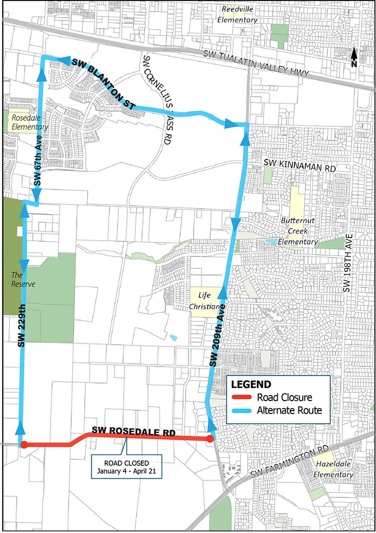
Rosedale Road, between between 209th and 229th avenues through April 21 for Willamette Water Supply System South Hillsboro Pipeline Project. Map
|
|
-
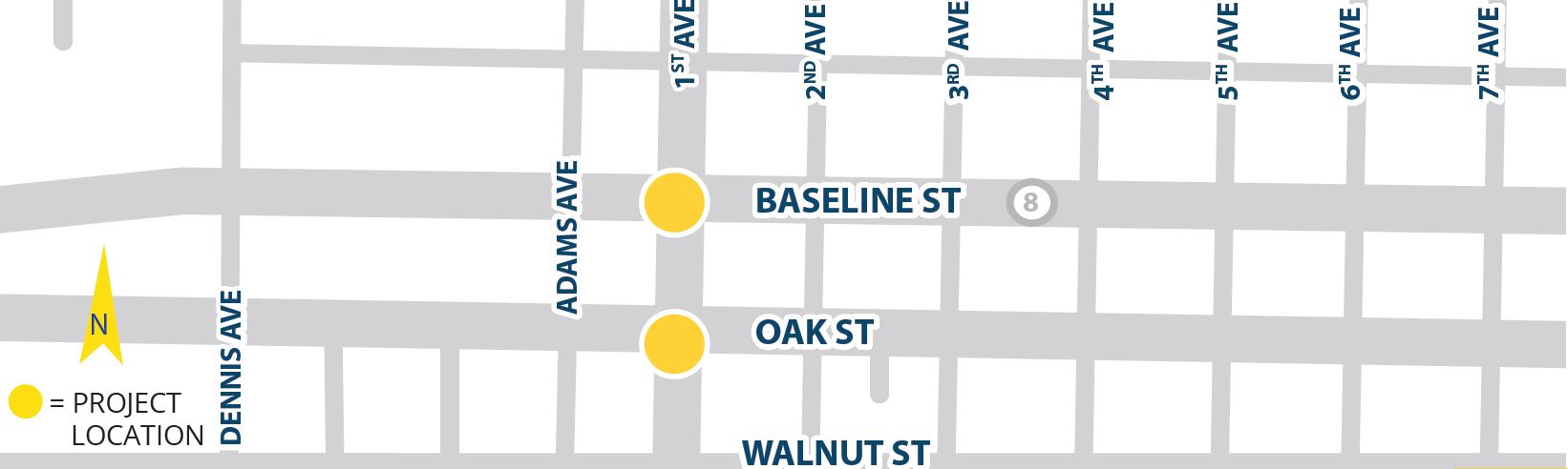
First Avenue (OR-219), between Baseline (OR-8) and Oak streets (OR-8), weeknights 7 p.m.-6 a.m. through Feb. 15 (extended) by Oregon Department of Transportation. Map
|
|
-
124th Avenue, between Tualatin-Sherwood Road and 2000 feet south of the intersection, 9 a.m.-3:30 p.m. weekdays through Jan. 29 for roadwork related to the PGE Integrated Operations Center. Map
|
|
-
Greenburg Road, between Hall Boulevard and Oak Street, 8 a.m.-5 p.m. weekdays through March 8, and nighttime signal shutdowns from 9 p.m.-5 a.m. between Hall Boulevard and Washington Square Road through March 20, for water main improvements by Tualatin Valley Water District. Map
|
|
-
Hampton Street, between 66th and 68th avenues, 7 a.m.-4:30 p.m. weekdays through Feb. 1 (extended) for Tualatin Valley Water District's Hampton-69th Avenue water main improvements. Map
|
|
-
Laidlaw Road, between Torin Terrace to East Road, 8:30 a.m.-4 p.m. weekdays through Feb. 26 for Riverside Homes. Map
|
|
-
Roy Rogers Road, between Scholls Ferry and Bull Mountain Roads. Speed reduction to 35 mph between Scholls Ferry and Bull Mountain roads and 45 mph between Bull Mountain and Beef Bend roads through December 2021 for road widening. Map
|
|
-
West Union Road, between 153rd Terrace and Bronson Creek Drive, 9 a.m.-3:30 p.m. Monday-Thursday and 9 a.m.-3 pm. Friday through April 1 for sidewalk installation. Map
|
|
ADA ramp replacements have minimal impact on motor vehicle traffic; pedestrian paths will be maintained. Lane closures will be intermittent during weekday hours only. Ramps are in construction on portions of the following roads:
- 149th Avenue at Surrey Court
- Bethany Boulevard
- Quatama Street
- West Union Road
|
|
Neighborhood meetings, required for many Washington County development applications, can be held online temporarily as per the new COVID-19 Virtual Neighborhood Meeting Supplement. The temporary supplemental policy is in effect for the duration of Gov. Kate Brown's "Stay Home. Save Lives" executive order.
|
|
Feb. 16 - Proposed greenhouse/office building |
|
Washington County Department of Land Use & Transportation
155 M First Ave., Ste 250, MS 16 | Hillsboro, OR 9714
|
|
|
|
|
|
|


