Dear Florida Climate Center Friends, | |
We'd like to present you with the Fall 2024 edition of our quarterly newsletter. In this newsletter, you'll find our most recent monthly climate summaries for the past three full months (June, July, August), a look at recent extreme rainfall and drought patterns that have impacted the state over the past few months, the latest on the development of La Niña, and the fall season outlook. You will also find an update on recent events and activities we've been engaged in over the past few months. If you have any questions, please send us an e-mail at climate@coaps.fsu.edu.
Thanks,
The Staff of the Florida Climate Center
| |
|
Monthly Climate Summaries for Florida | |
The Florida Climate Center's June, July, and August Climate Summaries for Florida are available, as well as previous monthly summaries. These summaries provide an analysis of temperature and precipitation patterns across the state, along with data on hazardous weather, drought, and daily records tied or broken each month.
During June, average temperatures were above normal. The monthly departures from normal ranged from -0.2 ̊F in Pensacola to +3.4 ̊F in Tallahassee. Many locations recorded one of their top five warmest Junes on record. Extreme heat with triple digit temperatures were observed in central Florida in early June, including in Orlando, Lakeland, Jacksonville, Kissimmee, Deland, and Clermont. A second round of extreme heat impacted North Florida from Crestview to Jacksonville on June 22-25.
Average temperatures in July were mostly well above normal for the month. The monthly mean temperature departures from normal ranged from -1.0 ̊F in Pensacola to +2.9 ̊F in Orlando. July 2024 became the warmest July on record statewide, and Orlando (129 years), Punta Gorda (104 years), Tampa Bay (38 years), and Ft. Lauderdale (109 years) also had their warmest July on record.
Average monthly temperatures in August continued to be above normal. Monthly mean temperature departures from normal ranged from +0.3 ̊F in Sarasota to +2.9 ̊F in Tallahassee. Several locations recorded one of their top 3 warmest Augusts on record. Pensacola saw several record-breaking hot days at or over 100 ̊F, and Key West smashed several daily temperature records, including 101 ̊F on the 10th and 102 ̊F on the 13th.
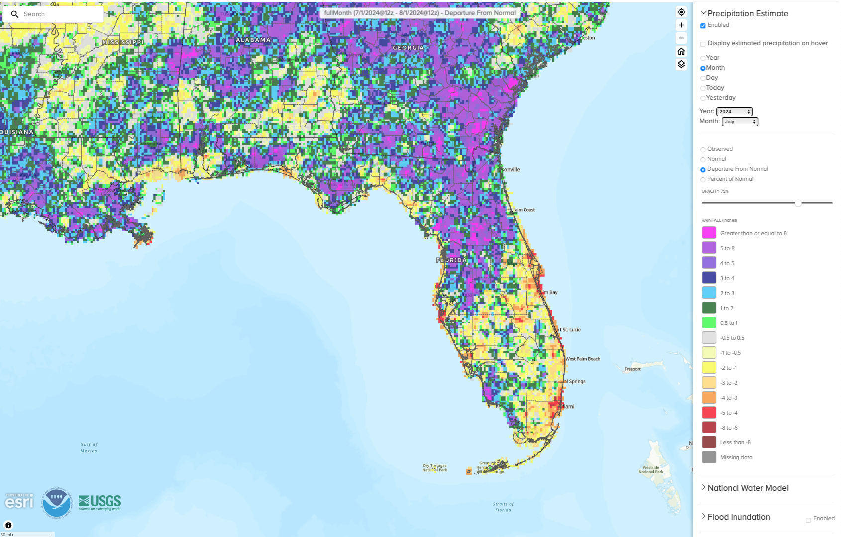
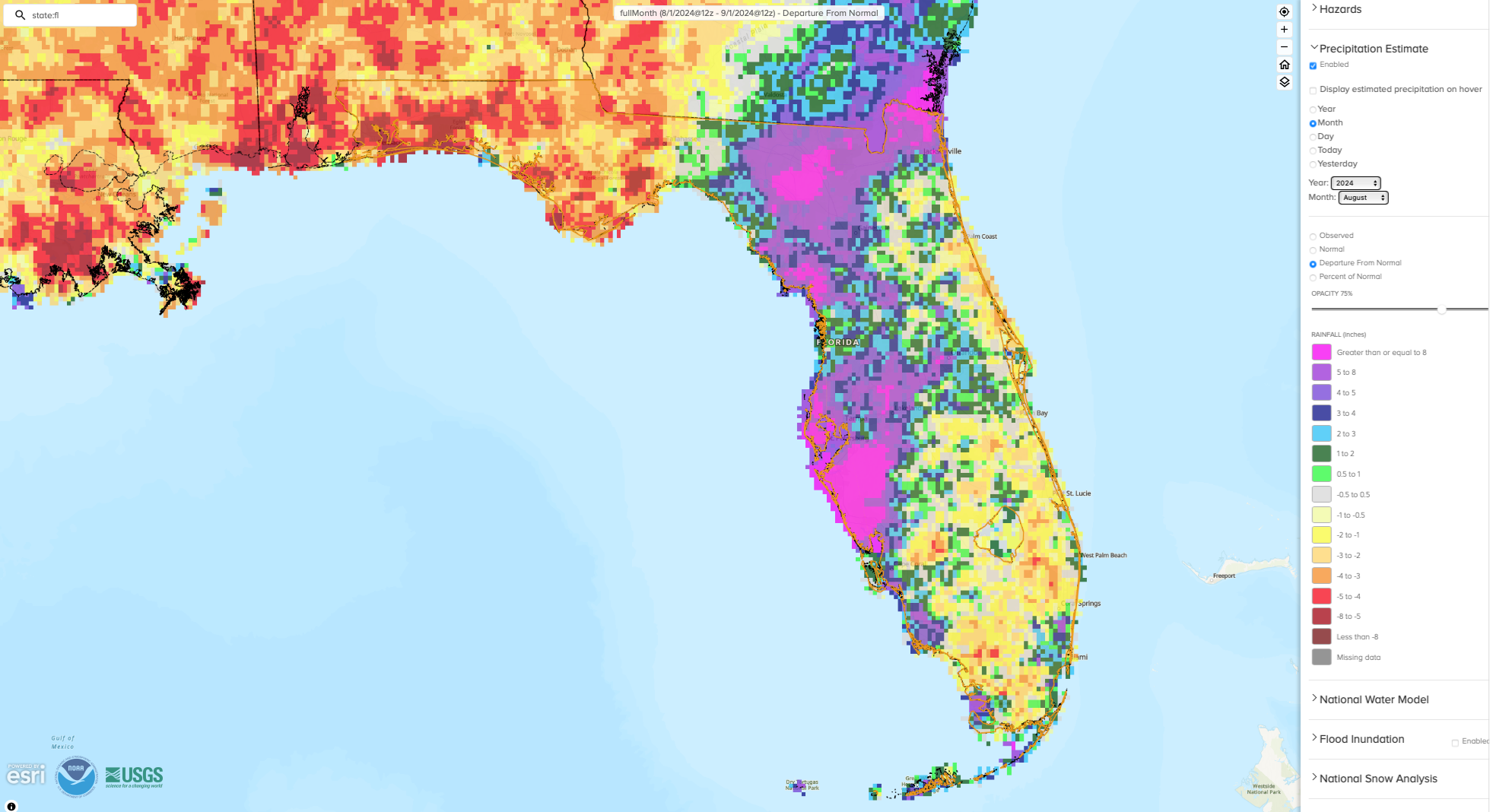
The figures below are graphical depictions of the monthly rainfall departure from normal (in inches) for June, July, and August (courtesy of the National Weather Service), as well as the 3-month seasonal rainfall departure from normal map (courtesy of the High Plains Regional Climate Center).
*Click on each map to view a larger image.
| |
Summer 2024 was Warmest Summer on Record in Florida | |
Despite being very wet this summer, the rain did not abate the heat. This summer became the warmest summer (June-August) on record for the state as a whole, according to data from the NOAA National Centers for Environmental Information. The statewide average summer temperature was 83.5°, +3°F above the long-term average, which tied with 1998. It was the 4th-warmest summer on record for the U.S.
June ranked as the 3rd-warmest June on record in Florida, with a statewide monthly average temperature of 82.5°, which was 3.0°F above normal. July 2024 was the warmest July on record in Florida, beating last year's record warm July, with a statewide monthly average temperature of 84.2°F, which was 3.2°F above average. August 2024 ranked 2nd-warmest on record, with a monthly statewide average temperature of 83.7°F, which was 2.6°F above the long-term average.
The top five warmest summers, June-August, on record for Florida are:
- 2024 – 83.5°
- 1998 – 83.5°
- 2010 – 83.3°
- 2023 – 83.1°
- 2016 – 83.0°
| |
Summer Brought Repeat Heavy Rainfall | |
|
Invest 90L
At the beginning of summer, Central and South Florida were experiencing moderate to severe drought. In mid-June, a system named Invest 90L brought warm, tropical moisture into the state, which never developed into a named storm but brought heavy rainfall to the region. Rainfall totals from this system were between 4 and 18+ inches from June 11-14, which led to flash flooding and inundated roadways. As a result of the system, drought ended and June 2024 became the wettest June on record for Fort Myers (120 years), 2nd-wettest in Fort Lauderdale (27 years) and Naples (23 years), 3rd-wettest in Sarasota (111 years), and 8th-wettest in Miami (88 years).
| |
|
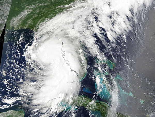
Hurricane Debby
August was much wetter than normal for areas impacted by Hurricane Debby, which made landfall in Florida's Big Bend region near Steinhatchee on August 5 as a category 1 hurricane. The storm affected Florida's Gulf Coast as it moved north through the Gulf of Mexico, bringing torrential rainfall, flooding and storm surge to coastal areas and across North-Central Florida. Storm rainfall totals peaked at just under 20 inches, with the largest amounts observed in the Sarasota area in Manatee County. CoCoRaHS observers recorded some of the highest storm totals, including Parrish 5.6 SE with a total of 18.86 inches of rain and Lakewood Ranch collected 18.34 inches from the storm, of which 16.04 inches was observed in one day. Read more about Debby's impacts in Florida here.
| |
|
As a result of Debby, along with typical summer weather, many stations accumulated impressive rainfall totals for the month of August. Select August monthly rainfall totals are shown in the table below, which includes stations from the COOP and CoCoRaHS networks. | |
| Location (Station ID) | August Monthly Rainfall Total (in inches) | | Lakewood Ranch (FL-MA-29) | 30.60 | | Sarasota/Bradenton AP | 23.55 | | Englewood (FL-SS-82) | 25.04 | | Parrish (FL-MA-40) | 28.93 | | Pinellas Park (FL-PN-90) | 24.40 | | North Port (FL-SS-14) | 19.15 | | Venice | 21.96 | | |
|
For the summer as a whole, Sarasota/Bradenton and Fort Myers had their wettest summers on record with 47.98" (19.97" above normal) and 43.87" (14.4" above normal) of total rainfall, respectively. Tampa had its 2nd-wettest summer on record with a total of 38.52" of rainfall, which was 14.37" above normal. Venice and Naples both had their 2nd-wettest summers on record as well, with 37.69" and 39.94" of rain, respectively.
As of August 31, many locations have already seen more rainfall than they typically do in an entire year. Year-to-date rainfall totals have far surpassed annual average rainfall amounts in Tampa, Sarasota, Ft. Myers, Naples, and Gainesville. This is a big change from last summer where much of the west central coast was in extreme drought.
| |
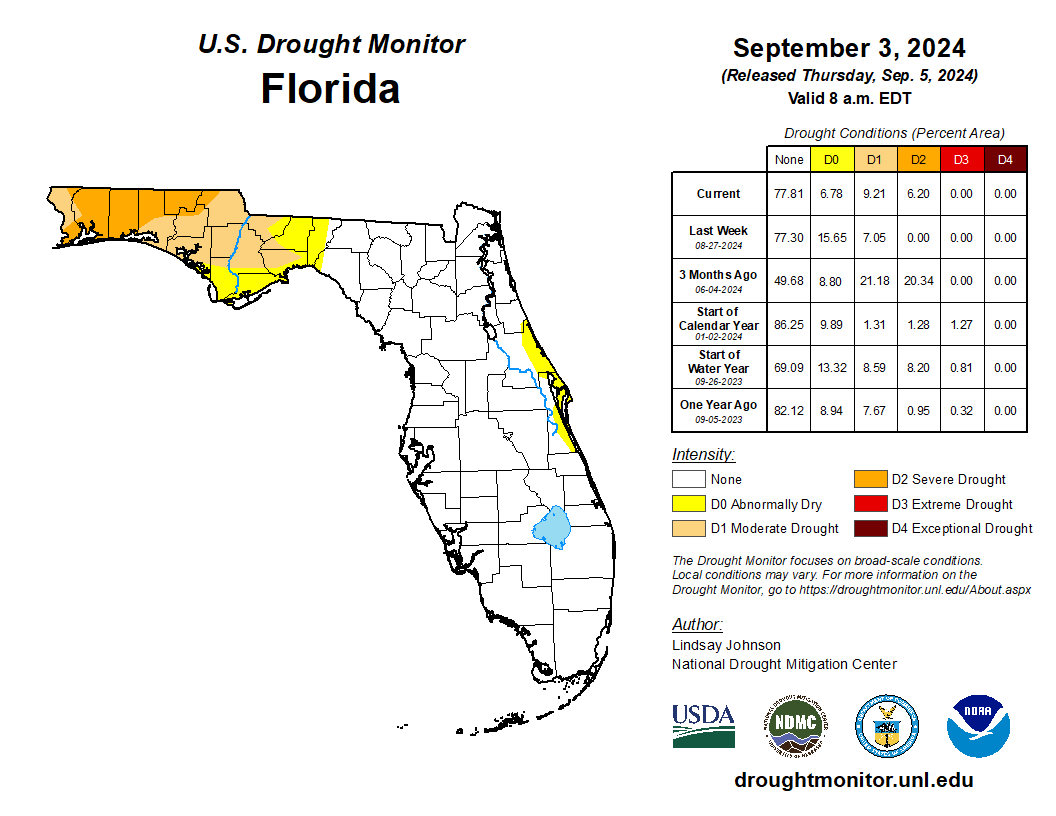
Summer Drought Patterns
Unlike the rest of Florida, the western Panhandle saw a dearth of rainfall over the summer, particularly in August. Pensacola recorded less than an inch of rain for the entire month of August, which was 6.5 inches below normal and the 2nd-driest August on record. By early September, severe drought (D2) had developed affecting 6.2% of the state, and moderate drought (D1) affected 9% of the state.
| |
What's Going on with the Atlantic Hurricane Season? | |
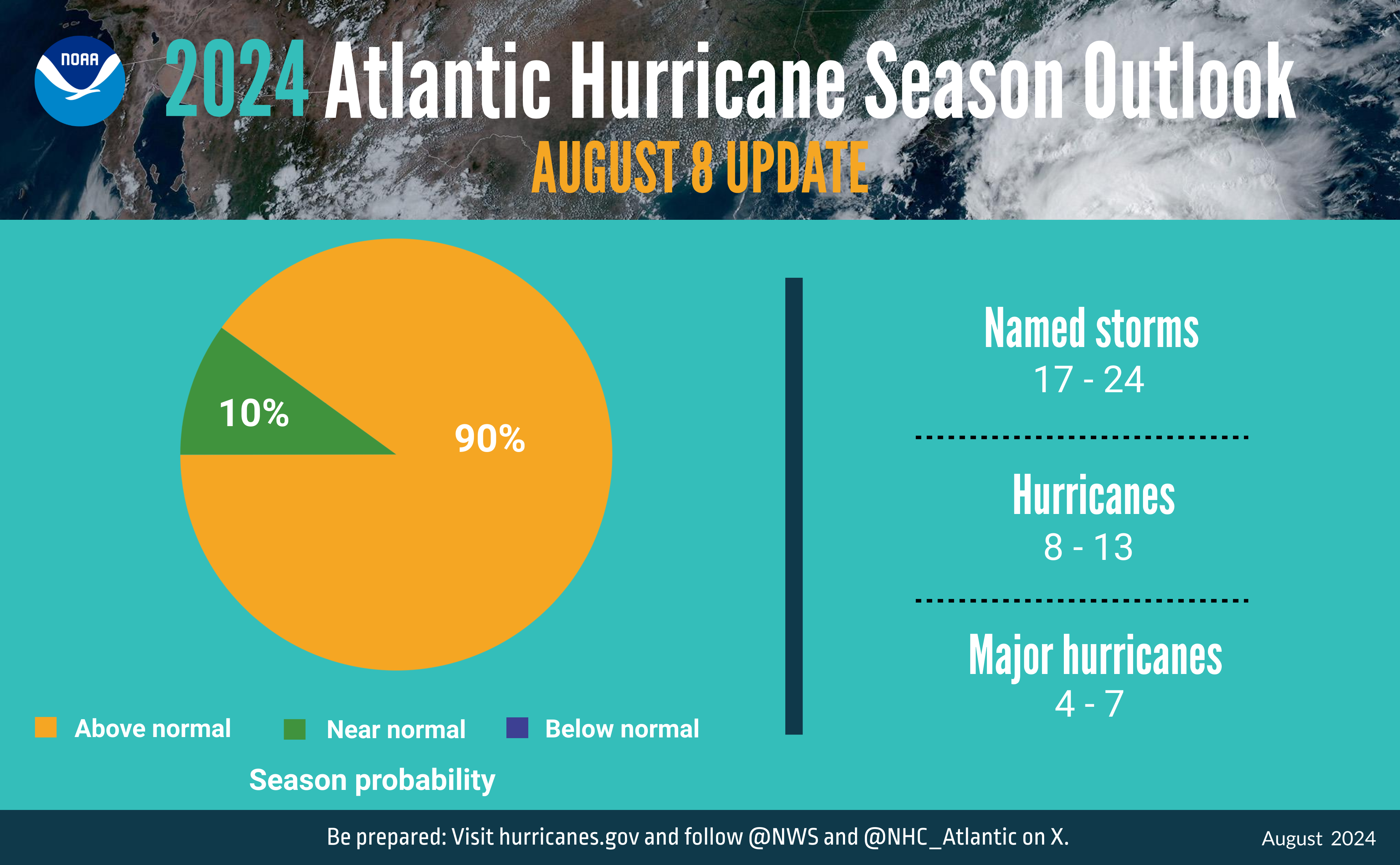
Several groups, including the National Oceanic and Atmospheric Administration (NOAA) and Colorado State University (CSU), released mid-season updates for the Atlantic Basin Hurricane Season Outlook in early August. NOAA's mid-season update, shown just below, is similar to its initial outlook issued in May. They continued to call for a very active, above-average Atlantic hurricane season.
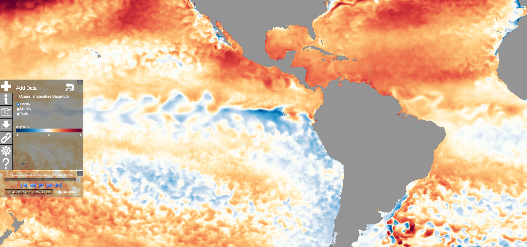
So far this season, there have been 7 named storms (Alberto, Beryl, Chris, Debby, Ernesto, Francine, and Gordon), including 4 hurricanes. However, from August 13 to September 3, no named storms developed in the Atlantic basin. The last time there were no named storms during this period in the Atlantic basin was 1968. With the recent lull in activity, we are now slightly behind climatology. Typically by mid-September, the season would have produced 9 named storms on average.
Several factors are influencing this year's forecast, including: 1) above-average sea surface temperatures in the tropical Atlantic Ocean and Caribbean Sea, 2) reduced vertical wind shear and the possibility of La Niña developing during the hurricane season, 3) weaker tropical Atlantic trade winds, and 4) an enhanced west African monsoon. Read more about the season so far in a discussion recently released by CSU.
|  | |
NOAA Issues La Niña Watch | La Niña conditions, the cool phase of the El Niño Southern Oscillation climate pattern in the tropical equatorial Pacific Ocean, are likely to develop in the coming months, though it has been slightly delayed from earlier forecasts. Forecasters are uncertain whether it will arrive in time to exert a strong influence on the Atlantic Hurricane season. Currently, there is a 71% chance La Niña will emerge during September - November 2024. Once it emerges, it is favored to persist through the Northern Hemisphere winter, January - March 2025. | |
Fall 2024 Leaning Warm and Wet in Florida | The NOAA Climate Prediction Center's outlook for the rest of this fall and early winter is leaning toward a warmer than normal fall season on average, October through December, in Florida and nearly the entire contiguous U.S. Precipitation during fall currently has equal chances of being above, below, or near normal in Florida. |
|
|
We’ve never seen a storm like Beryl. What a Cat 5 hurricane says about a warmer future – Miami Herald, July 3, 2024
City Council to consider storm water measures - WUWF, July 31, 2024
NOAA Affirms Expectations for Extraordinarily Active Hurricane Season - Inside Climate News, August 10, 2024
Tracking the heat index in Fort Myers: This July day felt the hottest so far in 2024 - News-Press, August 30, 2024
After a violent start, the Atlantic hurricane season has gone unusually quiet - Los Angeles Times, September 5, 2024
| |
Recent Engagements & News | |
2024 Florida Resilience Conference | |
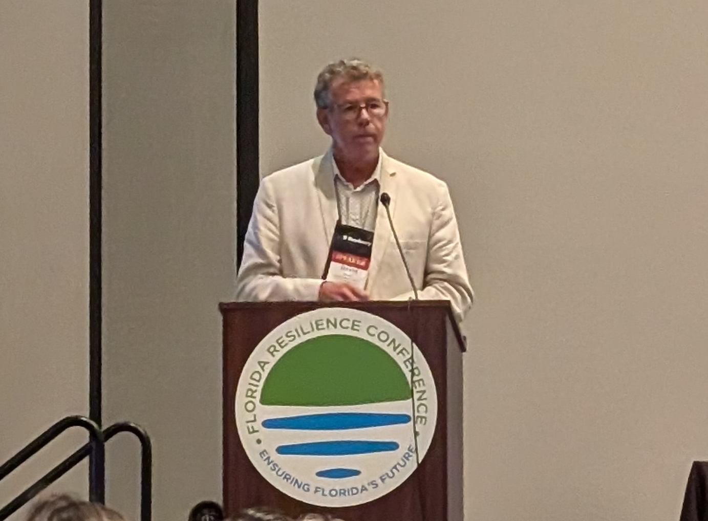
The Florida Climate Center participated in the Third Annual Florida Resilience Conference, hosted by the Florida Shore & Beach Preservation Association and Resiliency Florida, from September 11-13 in Bonita Springs. State Climatologist David Zierden delivered a presentation on the state of our weather. Assistant State Climatologist Dr. Emily Powell presented in the Smart Planning session about a project she is leading to provide technical assistance to Community Disaster Resilience Zones throughout the state of Florida in partnership with the Florida Climate Institute, University of Florida IFAS Extension, and Florida Sea Grant Extension. | |
|
2024 Annual Meeting of the American Association of State Climatologists | |
The Florida Climate Center attended the AASC annual meeting June 7-11 in Fort Collins, CO. Hosted by the Colorado State Climate Office, this annual meeting brings together federal, regional, and state partners, as well as other climate service providers, to discuss and share new programs, data, tools, and research related to climate services. | |
|
The Florida Climate Center is part of a three-tiered system of national, regional, and state climate offices, including NOAA's National Centers for Environmental Information (NCEI - in Asheville, North Carolina) and the Southeast Regional Climate Center (in Chapel Hill, North Carolina). The Florida State Climatologist and staff at the Florida Climate Center provide the following information and services to the people of Florida:
Climate Data
Historical weather observations for weather stations throughout the state of Florida. We are able to provide data for most stations from 1948-present.
Climate Information
Long-term historical averages for various stations, climate divisions, and the entire state.
Extreme Event Records
Information and analyses on extreme events such as freezes, droughts, floods and hurricanes.
Special Analysis
With their vast knowledge of El Niño, La Niña and climate variability, the State Climatologist and staff can offer expert insight into Florida's climate trends.
Outreach
Activities, presentations, and workshops that inform and educate the people of Florida about current and emerging climate issues. We also coordinate volunteers for the Community Collaborative Rain, Hail & Snow Network (CoCoRaHS).
| | | | |