Winter 2024-25 Newsletter | | |
Dear Florida Climate Center Friends, | |
We'd like to present you with the Winter 2024 edition of our quarterly newsletter. In this newsletter, you'll find our most recent monthly climate summaries for the past three full months, a recap of the 2024 hurricane season, the latest on the probability of a La Niña event, and the winter season outlook. You will also find an update on recent events and activities we've been engaged in over the past few months. If you have any questions, please send us an e-mail at climate@coaps.fsu.edu.
Wishing you a wonderful holiday season!
The Staff of the Florida Climate Center
| |
|
Monthly Climate Summaries for Florida | |
The Florida Climate Center's September, October, and November Climate Summaries for Florida are available, as well as previous monthly summaries. These summaries provide an analysis of temperature and precipitation patterns across the state, along with data on hazardous weather, drought, and daily records tied or broken each month.
Average monthly temperatures were generally above normal in September. The monthly departures from normal ranged from -1.1 ̊F in Pensacola to +2.5 ̊F in West Palm Beach.It was record warm across South Florida during the month. September 2024 ranked as the warmest September on record in Key West (150 years), West Palm Beach (131 years), Punta Gorda (108 years), Vero Beach (81 years), and Plant City (115 years).
Average temperatures in October were near to above normal for the month. The monthly mean temperature departures from normal ranged from -0.4 ̊F in Sarasota to +2.0 ̊F in Daytona Beach. October experienced wide temperature swings associated with changing upper air patterns. A cold front brought well below normal temperatures across the Panhandle and northern Florida mid-month. Much above normal temperatures followed as a ridge of high pressure set in later during the month.
Average monthly temperatures in November were above normal. Monthly mean temperature departures from normal ranged from +1.4 ̊F in Key West to +8.0 ̊F in Tallahassee. The Panhandle was especially warm during the month, with many locations recording their warmest or 2nd-warmest November on record. Stations across the Peninsula experienced one of their top ten warmest Novembers on record.
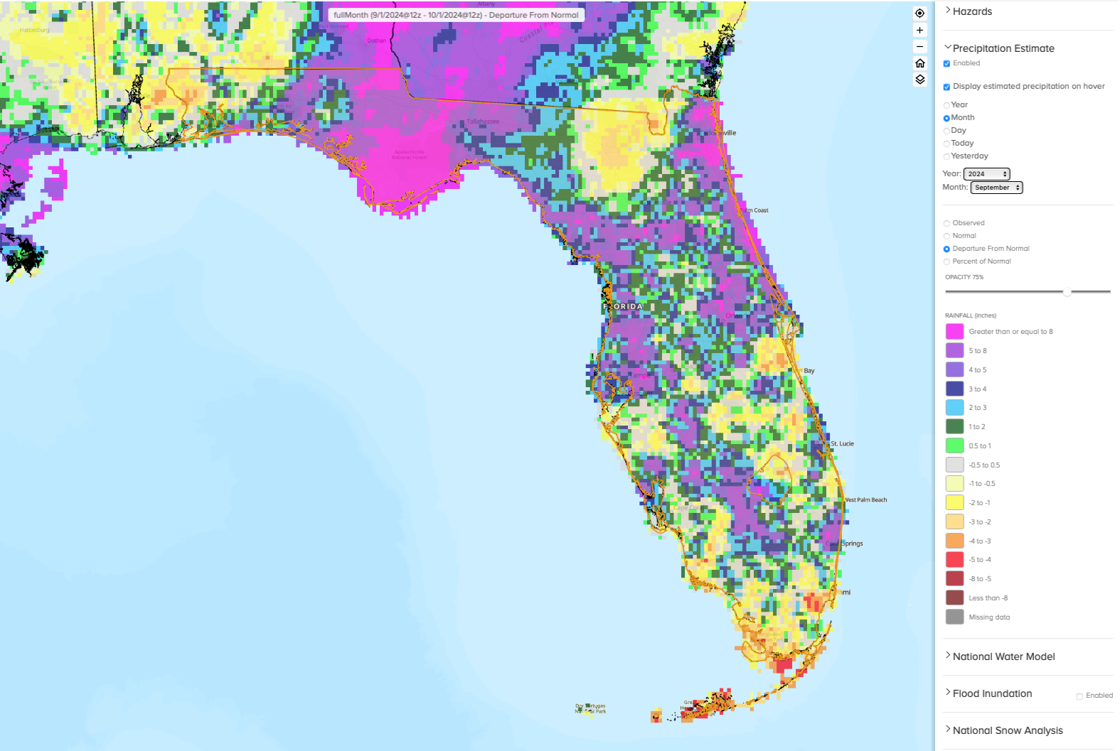
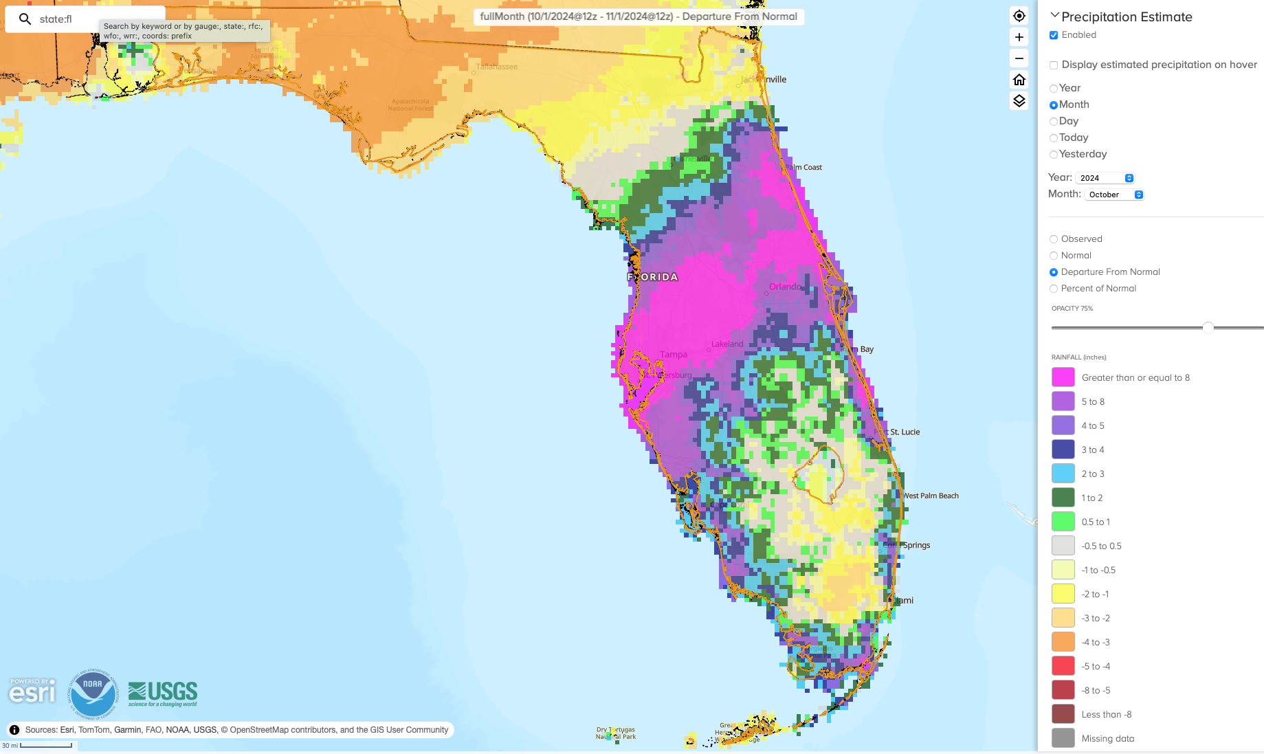
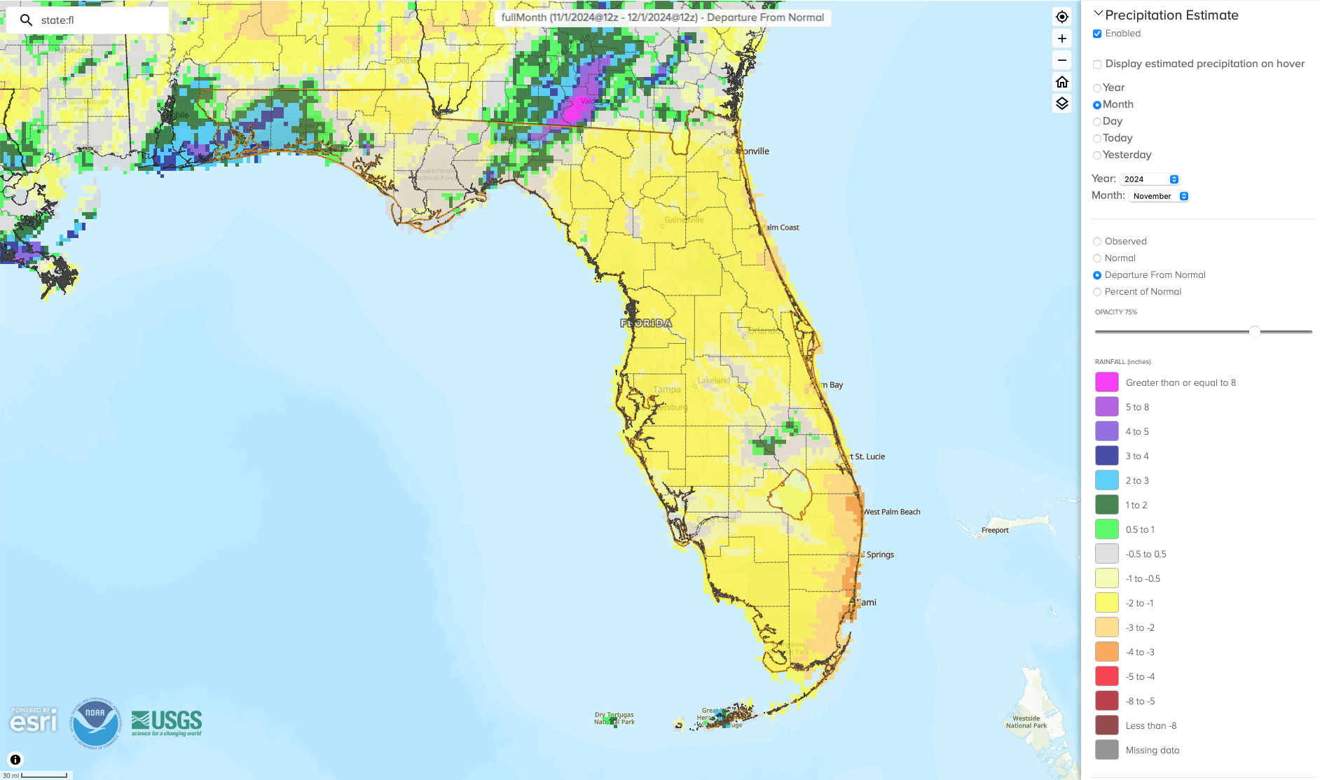
The figures below are graphical depictions of the monthly rainfall departure from normal (in inches) for September, October, and November (courtesy of the National Weather Service), as well as the 3-month seasonal rainfall departure from normal map (courtesy of the High Plains Regional Climate Center).
*Click on each map below to view a larger image.
| |
|
The footprints of Hurricanes Helene and Milton are visible in the monthly rainfall departure from normal maps above. Stations affected by Hurricane Milton experienced record or near-record wet conditions this fall season overall. Tampa had its wettest fall on record (135 years) with 29.27" total (SON), which was 19.44" above normal. Daytona Beach had its 2nd-wettest fall (88 years) with 26.90" of rain for the season, which was 12.14" above normal. Several additional locations had their 3rd-wettest fall on record, including Apalachicola (30.08" total), Titusville (26.89" total), Leesburg (18.08" total), and Vero Beach (28.38" total).
View monthly Climate Summaries for more information, including temperature and precipitation totals and departures from normal for select cities, daily records tied or broken, severe weather, as well as drought and soil moisture conditions.
| |
Fall 2024 Ranks as 4th-Warmest on Record in Florida | Statewide, the seasonal average temperatures, September-November, averaged out to be 75.4°F, which is +3.5°F above the long-term average. This ties as the 4th-warmest fall on record for Florida, tied with 1985. For the U.S., fall 2024 was record warm with a seasonal average temperature of 57.62°F which was +4.08°F above average, according to the NOAA National Centers for Environmental Information. | |
2024 Atlantic Hurricane Season Recap: Another Extremely Active and Impactful Season | |
The 2024 Atlantic Hurricane Season ended up being another very active and above-average hurricane season. The season produced a total of 18 named storms, including 11 hurricanes and 5 major hurricanes (category 3-5). The Accumulated Cyclone Energy (ACE), a metric for the overall intensity and duration of all storms, was about 135% of normal. Florida was directly impacted by 3 hurricanes, including 2 major back-to-back hurricanes. | |
|
In late June, Hurricane Beryl developed and intensified into a major hurricane on June 30, becoming the earliest major hurricane (category 3+) and earliest category 5 hurricane to form in the Atlantic Ocean basin on record. Beryl did not impact Florida; the storm made landfall in the western Gulf of Mexico near Matagorda, Texas as a Category 1 hurricane, impacting parts of Texas and Louisiana.
Early season activity was followed by a lull in tropical development during the time when it is typically most active from about mid-August to mid-September. According to NOAA, this lull was the result of stormier weather over Western Africa. Easterly waves that track west and often develop into hurricanes in the Atlantic's Main Development Region exited the African continent further north than usual where they were met with a more hostile environment for tropical development. The second half of the hurricane season, however, picked back up with 12 named storms forming after the climatological peak.
Florida was directly impacted by three landfalling storms – Debby, Helene, and Milton – two of which were major hurricanes and all three of which impacted Florida’s western Gulf coast. Major damages resulted from all three hurricanes, including record high storm surge along Florida's west coast, severe coastal erosion and sand displacement, and a record tornado outbreak with 47 confirmed tornadoes during Hurricane Milton. Category 3 Milton made landfall on the west coast in Sarasota County just less than 2 weeks after Hurricane Helene struck Taylor County in the Big Bend as a major category 4 hurricane. The two storms set a new record for number of days between two major hurricane landfalls in Florida (at 13 days), breaking the old record set in 1950 (44 days between Hurricanes Easy and King).
More information on individual storms is available through our post-storm summary reports.
| |
Drought Developed Following Major Hurricanes
Following Hurricanes Helene and Milton, a drying pattern set in during late October that lasted through November. Tallahassee recorded 30 consecutive days without measurable rainfall from October 6 - November 6, while the rest of the Panhandle saw between 26 and 29 consecutive days without measurable rainfall (defined as number of days with <0.01 inches). Below-normal rainfall combined with above-normal temperatures led to drought development in the Panhandle beginning in early November. By early December, nearly 19% of the state was in moderate drought (D1), and an additional 39% of the state was considered abnormally dry (D0), according to the U.S. Drought Monitor.
| |
|
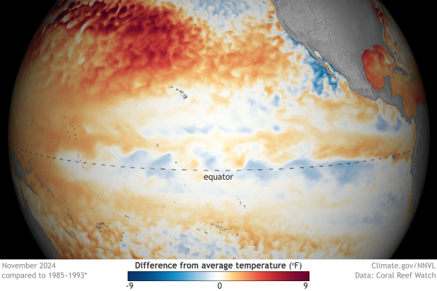
Sea surface temperatures in the central and eastern equatorial Pacific Ocean have been near average and show evidence of ENSO-neutral conditions. The latest weekly Niño indices of sea surface temperature anomalies ranged from +0.1°C (Niño-1+2) to -0.4°C (Niño-3), according to the Climate Prediction Center.
There is still a 57% chance that La Niña will emerge this winter (December 2024 - January 2025), and models indicate it will be a weak and short lived La Niña. A weak La Niña event could still yield typical winter impacts, which in Florida means drier and warmer than normal conditions, though this may be less likely. A transition back to ENSO-neutral conditions is anticipated by March-May 2025 (61% chance).
| |
Winter 2024-2025 Leaning Warmer and Drier Than Normal in Florida | The NOAA Climate Prediction Center's outlook for the winter season is leaning toward a warmer than normal fall season on average, December through February, in Florida. Winter precipitation is expected to be below normal, and drought is likely to persist or develop across the state. |
|
|
After a violent start, the Atlantic hurricane season has gone unusually quiet - Los Angeles Times, September 5, 2024
Florida’s politicians’ climate denial draws destructive response from Helene - Florida Phoenix, October 3, 2024
Supercharged storms: how climate change amplifies cyclones - Phys.org, October 3, 2024
How common are back-to-back hurricanes? A climatologist answers - Vox, October 9, 2024
Florida Climate Center: Milton's peak surge levels pass Helene, but not Ian in SW FL - News-Press, October 10, 2024
Winter is a month away in Tampa Bay. Here’s what forecasters expect - Tampa Bay Times, November 5, 2024
| |
Florida BRACE Program Hosts CDC Climate and Health Team at FSU | |
|
The Florida Building Resilience Against Climate Effects (BRACE) Program, funded by the Centers for Disease Control and Prevention (CDC), hosted members of the CDC Climate and Health team in early December to discuss ongoing work by Florida BRACE and partners. The Florida BRACE Program has been working since 2010 to assist the public health sector in responding to the effects of climate variability and change. This meeting included Florida BRACE team members Dr. Chris Uejio (PI), Dr. Tisha Holmes (Lead Evaluator), Dr. Emily Powell (Program Coordinator), Dr. Kyusik Kim (postdoctoral research scientist), and Mei Chen (graduate research assistant), as well as several members of the FL BRACE Advisory Group.
Research topics discussed included challenges around Special Needs Sheltering in Florida; the emergency power rule which limits indoor temperatures within nursing homes during power outages; and housing quality. Other discussion topics included environmental public health tracking; challenges around disaster, climate and health messaging; and emergency management and public health coordination. The Florida BRACE team will be publishing and disseminating some of this research later in 2025.
| |
The Florida Climate Center is part of a three-tiered system of national, regional, and state climate offices, including NOAA's National Centers for Environmental Information (NCEI - in Asheville, North Carolina) and the Southeast Regional Climate Center (in Chapel Hill, North Carolina). The Florida State Climatologist and staff at the Florida Climate Center provide the following information and services to the people of Florida:
Climate Data
Historical weather observations for weather stations throughout the state of Florida. We are able to provide data for most stations from 1948-present.
Climate Information
Long-term historical averages for various stations, climate divisions, and the entire state.
Extreme Event Records
Information and analyses on extreme events such as freezes, droughts, floods and hurricanes.
Special Analysis
With their vast knowledge of El Niño, La Niña and climate variability, the State Climatologist and staff can offer expert insight into Florida's climate trends.
Outreach
Activities, presentations, and workshops that inform and educate the people of Florida about current and emerging climate issues. We also coordinate volunteers for the Community Collaborative Rain, Hail & Snow Network (CoCoRaHS).
| | | | |