Dear Florida Climate Center Friends, |
We'd like to present you with the Summer 2022 edition of our quarterly newsletter. In this newsletter, you'll find our most recent monthly climate summaries; an update on the La Niña Advisory, and a mid-season update on the 2022 Atlantic hurricane season. You will also find the fall climate outlook, and an update on events and activities we've been engaged in. If you have any questions, please send us an e-mail at climate@coaps.fsu.edu.
Thanks,
The Staff of the Florida Climate Center
|
|
|
Monthly Climate Summaries for Florida |
The Florida Climate Center's June, July, and August Climate Summaries for Florida are available, as well as previous monthly summaries. These summaries provide an analysis of temperature and precipitation patterns during the months of June through August across the state, along with data on hazardous weather, drought, and daily records tied or broken each month.
Average temperatures in June were near or above normal. The monthly departures from normal ranged from -1.5 ̊F in Key West to +2.9 ̊F in Tallahassee. Heat waves impacted the state during the month. Several places experienced triple digit temperatures during mid to late June, including Pensacola and Crestview to as far south as Clermont.
Average temperatures in July were near to above normal. Monthly mean temperature departures from normal ranged from -0.3 ̊F in Key West to +2.5 ̊F in Tampa. Jacksonville Beach, Tampa, and Plant City had their hottest July on record; Orlando and Fort Lauderdale had their 2nd-hottest July on record.
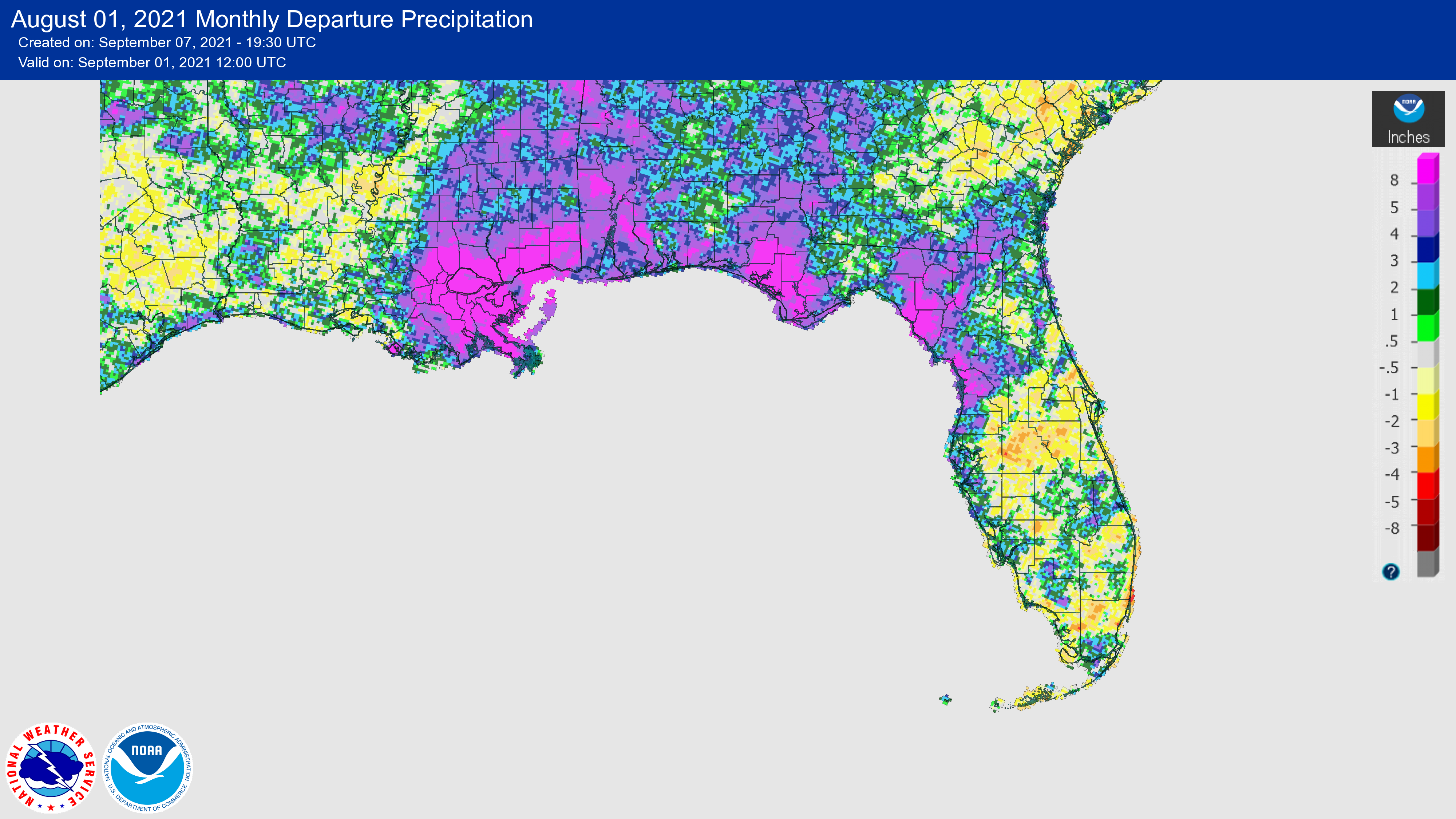
Average temperatures in August were near normal in the Panhandle and above normal in the Peninsula. The monthly temperature departures from normal ranged from -0.6 ̊F in Key West to +2.4 ̊F in West Palm Beach. Many locations had their hottest August on record, including Clermont, Tampa, Fort Myers, West Palm Beach, and Hollywood.
Summer of 2022 (June-August) has been warmer than normal for much of the state. Most locations experienced one of their top ten hottest summers on record, and Tampa, Orlando, Clermont, Plant City, and Jacksonville Beach all had their hottest summers on record.
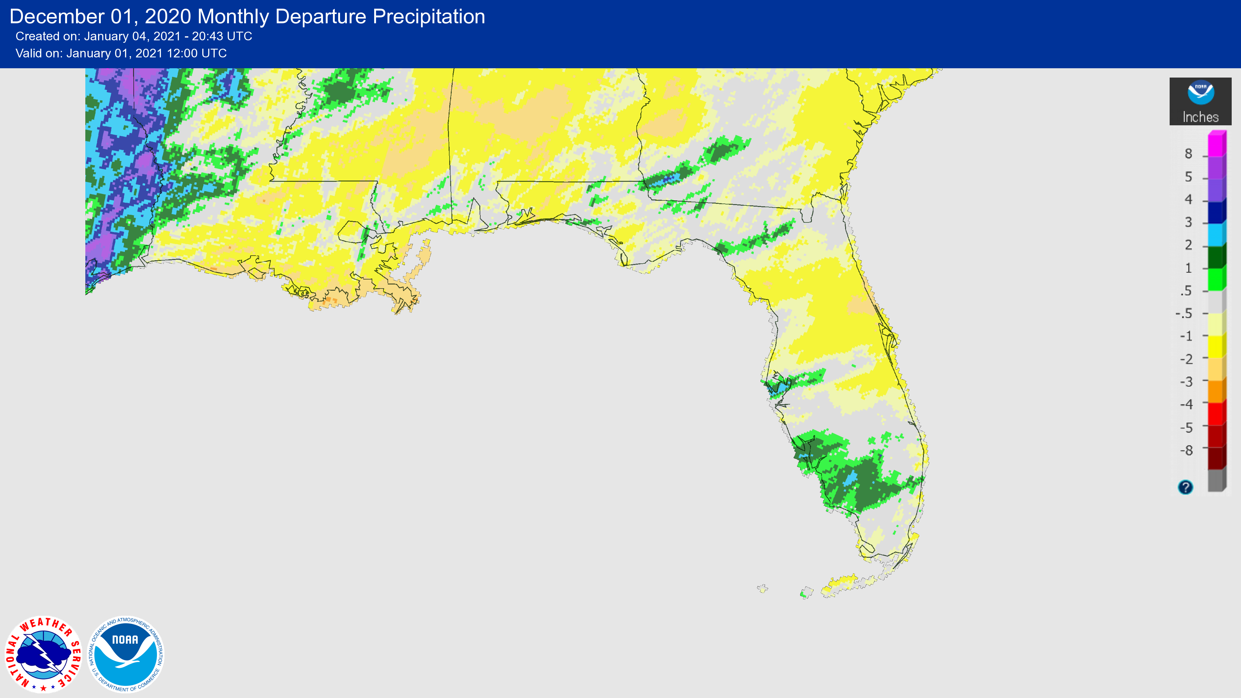
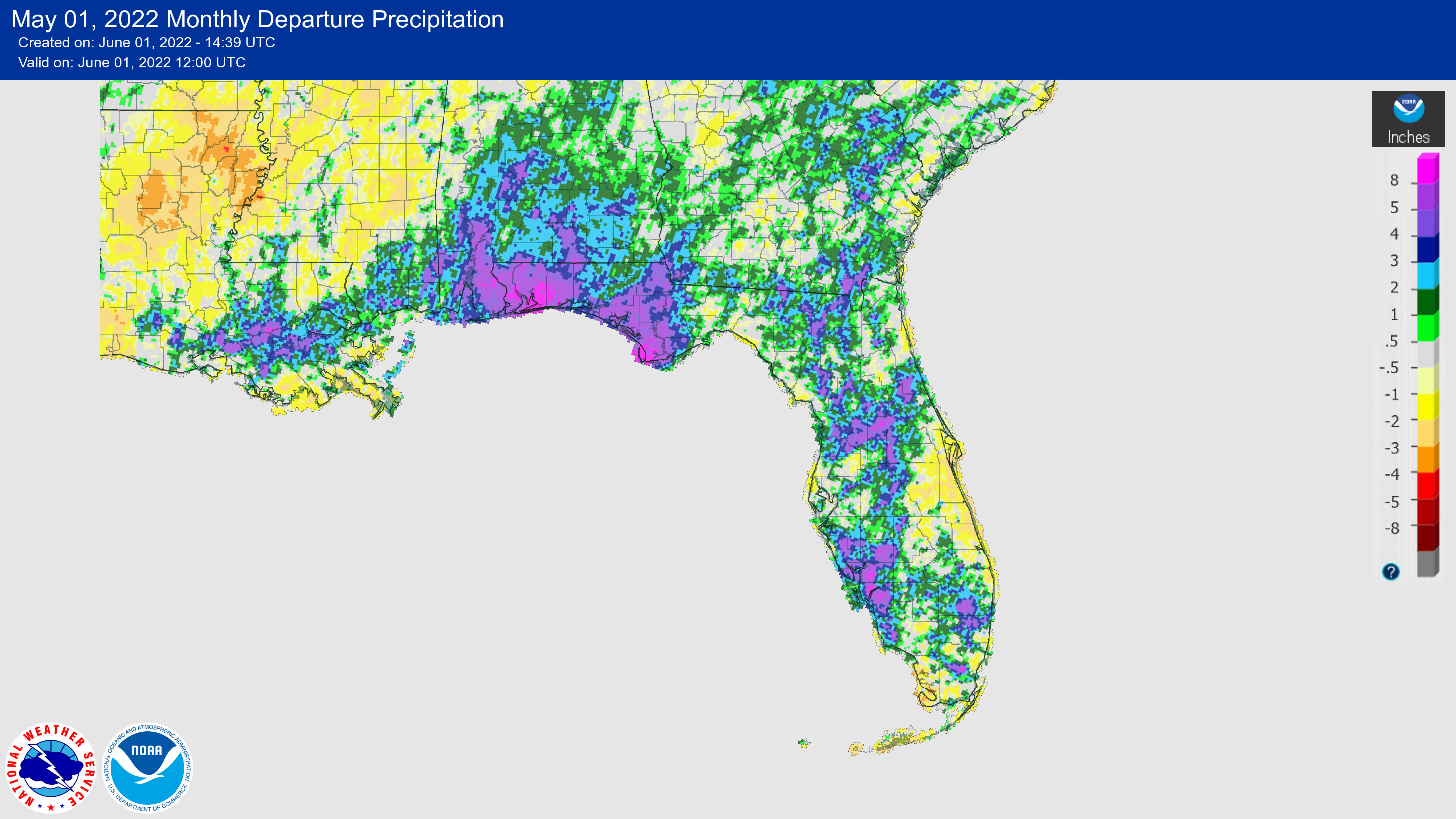
The figures below are graphical depictions of the monthly rainfall departure from normal (in inches) for June, July, and August (courtesy of the National Weather Service).
|
|
La Niña conditions, the cool phase of the El Niño-Southern Oscillation (ENSO) climate pattern, are nearly certain to continue in the tropical Pacific Ocean this fall, with a 91% chance September-November 2022. This also means the odds for having a winter La Niña for a third year in a row have risen to over 90%. Chances for La Niña decrease to 54% from January-March 2023.
During August, sea surface temperatures (SSTs) remained below average across the central and eastern equatorial Pacific Ocean. The largest SST anomalies were in the Niño-3.4 and Niño-4 regions, where the latest weekly values reached -0.8 ̊C and -1.1 ̊C, respectively, indicating that La Niña remains strongly in place.
While it's looking like we will have a La Niña winter for the third year in a row, there is uncertainty over how long La Niña will last. Currently, there is a 56% chance for a transition to ENSO-neutral conditions during February-April 2023.
|
|
2022 Atlantic Hurricane Season Update |
Even if you haven't been paying close attention, you probably realize this year has been a rather quiet hurricane season so far in the Atlantic. As of August 31, there were 3 named storms and 0 hurricanes in the Atlantic basin. This officially put us behind climatology, with August having no named storms.
So what has been behind the lull in activity so far?
Despite the presence of strong climate signals, including La Niña, which is typically associated with more active Atlantic hurricane seasons, and warm Atlantic and GOM sea surface temperatures (SSTs), the weather patterns have created less-than-ideal conditions for storm development across the tropical Atlantic main development region.
Firstly, the tropical Atlantic region has been impacted by large Saharan Dust Layers and dry air masses over the past couple of months that have inhibited convective activity and suppressed SSTs early in the season in some areas. Secondly, the broad area of high pressure that we normally associate with active seasons (known commonly as the Bermuda High) has been situated well north of the subtropical Atlantic Ocean. This displacement of the high pressure system further north has contributed to abnormally warm SSTs over the North Atlantic Ocean, while allowing for the jet stream and more wind shear to impact the tropical Atlantic region, thus preventing well-organized storms from developing.
|
|
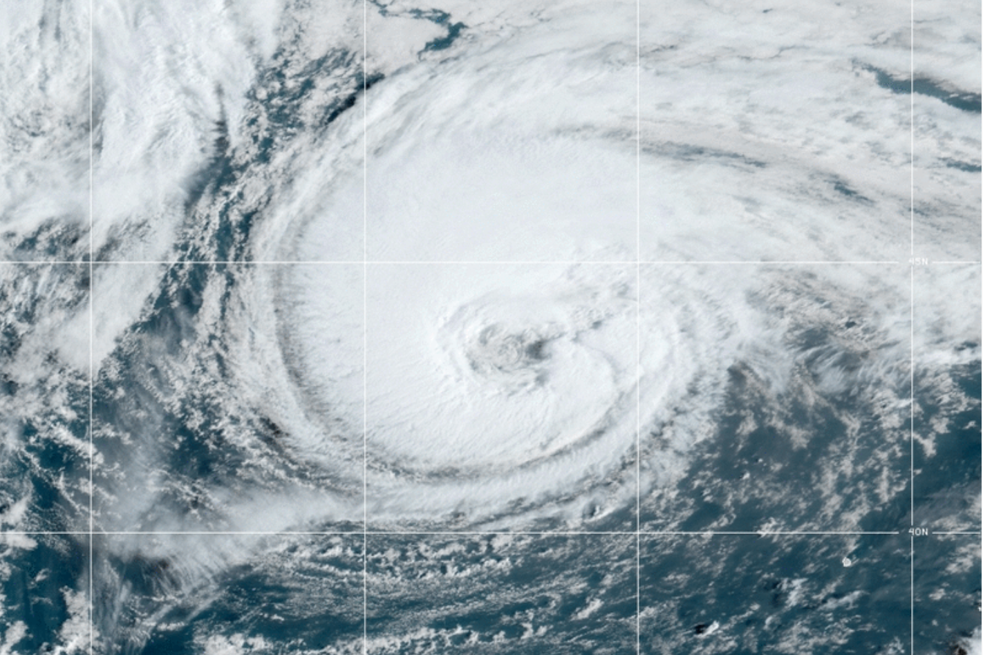
After a 60-day streak with no named storms since TS Colin dissipated on July 3, Danielle formed September 1 and became the first hurricane of the season on the 2nd, 22 days behind normal for the development of the season's first hurricane. Danielle is among the northernmost locations for a hurricane to form. It also underwent rapid intensification, by 35 mph in 24 hours. The storm maintained hurricane strength unusually far north, above 40 degrees latitude, due in part to the presence of abnormally warm SSTs in this region. |
|
|
|
|
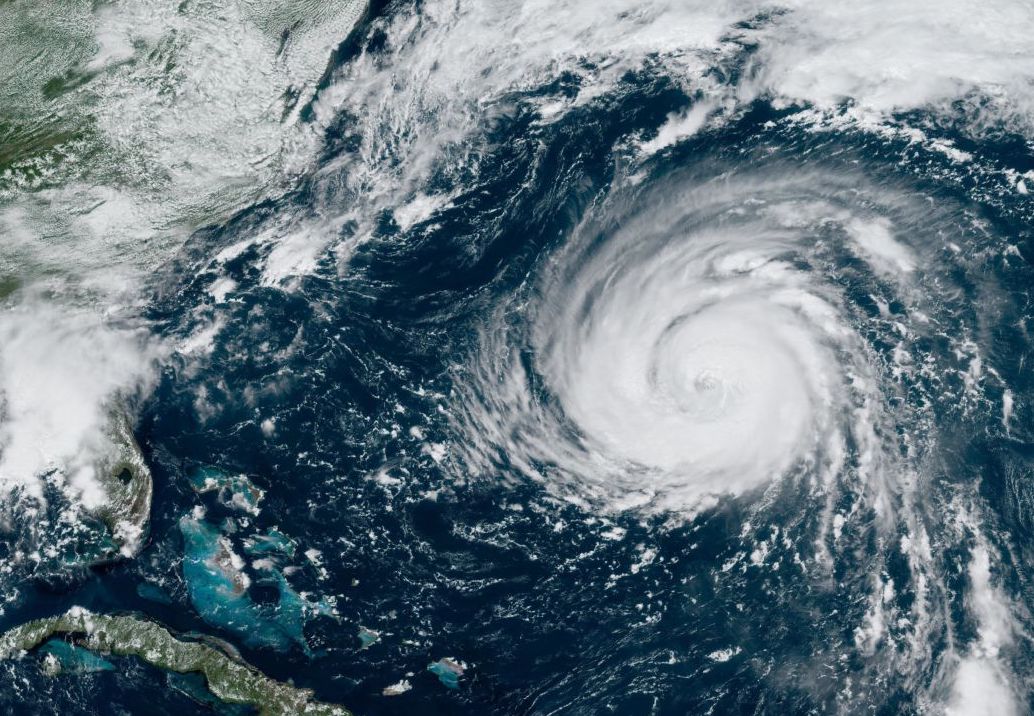
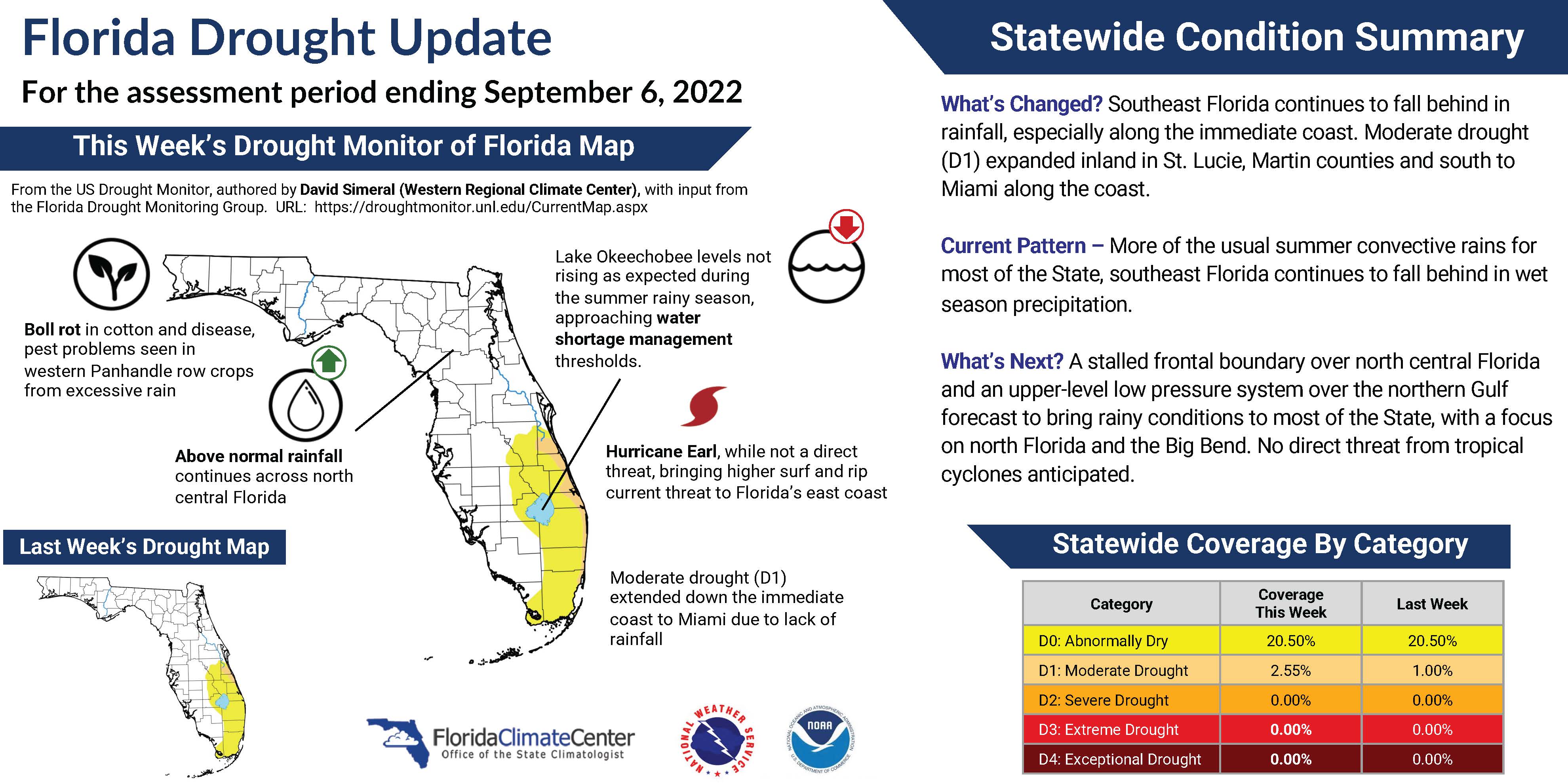
Shortly after, Hurricane Earl formed on September 7, 12 days behind normal for the second hurricane of the season. While Earl did not directly impact the U.S., it created high surf and strong rip currents along the Eastern Seaboard including Florida. Earl also maintained hurricane strength far north above 42 degrees north latitude. |
|
New FCC Weekly Drought Resource |
In case you missed it, the Florida Climate Center has started producing a weekly drought status infographic for Florida. These weekly updates provide a brief synopsis of the current drought conditions across the state, including changes since the prior week and what to expect over the following week. This information is compiled for input to the U.S. Drought Monitor. The template and idea for this infographic came from the North Carolina State Climate Office, which they shared at the Southeast Drought Early Warning System (DEWS) Partner Meeting last month in Atlanta, GA.
You can access the weekly drought update on our website HERE or follow us on social media!
|
|
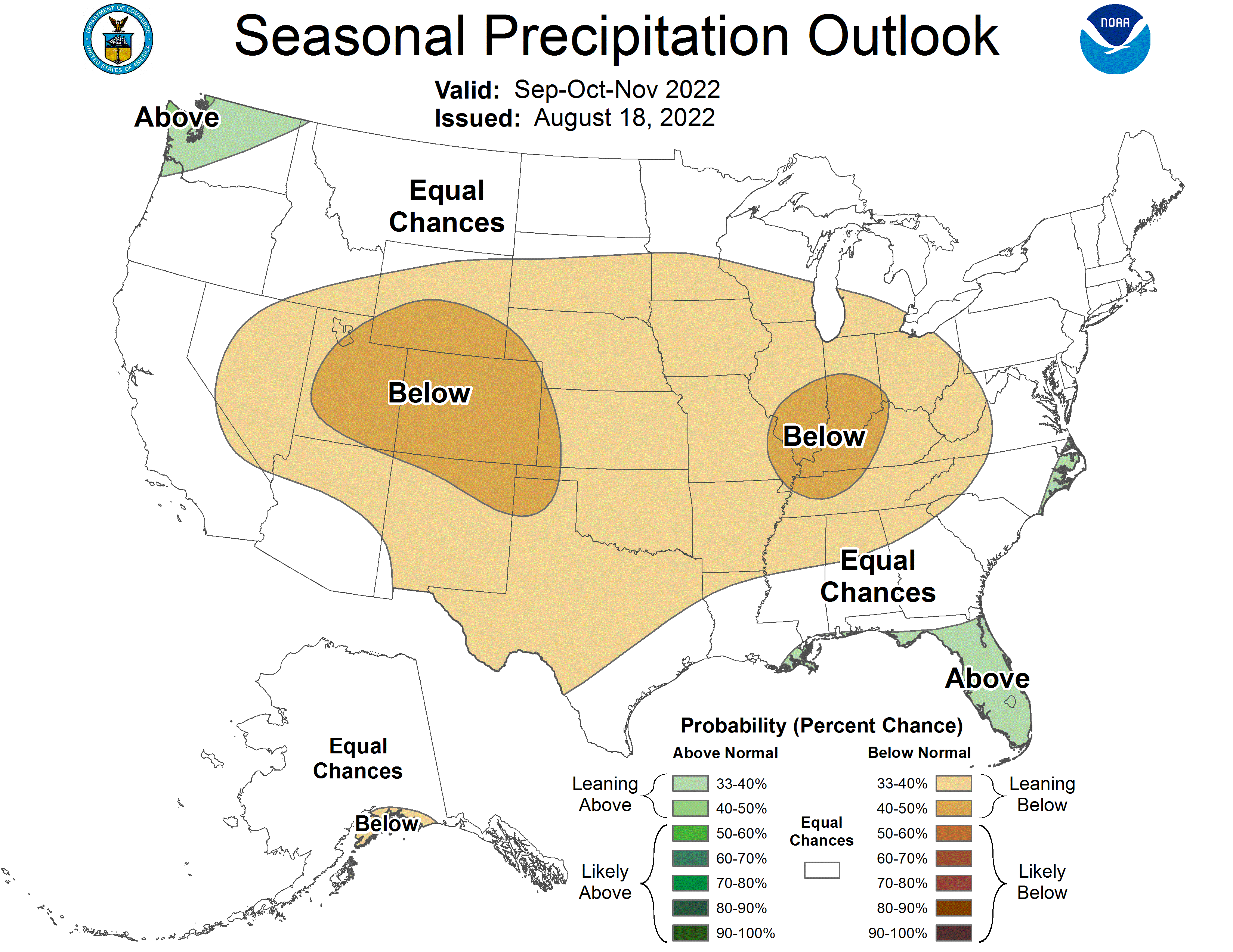
The Seasonal Outlook for Fall is Leaning Warmer and Mostly Wetter than Normal for Florida |
NOAA's Climate Prediction Center anticipates a warmer than normal fall season, September to November, for much of the country. Florida has a 40-50% chance of above normal temperatures. Precipitation is leaning above normal for much of Florida, except in extreme northern Florida where it has equal chances for above, below and near normal rainfall. |
|
New Federal Climate Resources |
|
HEAT.gov - A n ew NIHHIS (National Integrated Heat Health Information System) resource and web portal for extreme heat services, designed to support equitable heat resilience.
Resilience.climate.gov - A new climate website that helps people assess their local exposure to climate-related hazards. This new tool is designed to help communities build resilience. It integrates decision-relevant information from across the U.S. Federal government and includes climate maps and data, non-climate data, and federal funding opportunities.
|
|
The Florida Climate Center will be co-organizing a panel at the Florida Resilience Conference, October 5-7, 2022 on regional resilience challenges across the state.
More information about the conference is available HERE.
|
|
Southeast Climate Monthly Webinar Series
This webinar series, hosted by the Southeast Regional Climate Center in partnership with the National Integrated Drought Information System (NIDIS) and the NOAA National Weather Service, is held on the 4th Tuesday of each month at 10am ET. The next webinar is September 27 and the special presentation will showcase two modernized water data delivery products from the USGS. Register here.
|
|
The Florida Climate Center is part of a three-tiered system of national, regional, and state climate offices, including NOAA's National Centers for Environmental Information (NCEI - in Asheville, North Carolina) and the Southeast Regional Climate Center (in Chapel Hill, North Carolina). The Florida State Climatologist and staff at the Florida Climate Center provide the following information and services to the people of Florida:
Climate Data
Historical weather observations for weather stations throughout the state of Florida. We are able to provide data for most stations from 1948-present.
Climate Information
Long-term historical averages for various stations, climate divisions, and the entire state.
Extreme Event Records
Information and analyses on extreme events such as freezes, droughts, floods and hurricanes.
Special Analysis
With their vast knowledge of El Niño, La Niña and climate variability, the State Climatologist and staff can offer expert insight into Florida's climate trends.
Outreach
Activities, presentations, and workshops that inform and educate the people of Florida about current and emerging climate issues. We also coordinate volunteers for the Community Collaborative Rain, Hail & Snow Network (CoCoRaHS).
|
|
|
|
|
|
|