This is the time of the year when we’re looking forward to seeing everyone at our fall meeting for GCOOS members and partners. We’re still busy planning, but this year we’ll be hosting you virtually from 1 to 3 p.m. on Wednesday, Sept. 30 instead of seeing you in person.
I hope our new online platform will allow more of you to attend to hear the latest updates on ocean observing in the Gulf! Knowing that everyone is probably getting a lot of screen time, we kept the program short. Check out the agenda and be sure to bookmark the meeting link!
“See” you later this month!
|
|
GCOOS Fall Meeting Agenda: 1-3 p.m. Wednesday, Sept. 30, 2020
|
|
1-1:15 p.m.: Welcome from Dr. Sara Graves, GCOOS Board Chair. Roll call, welcome to new Board members and announcement of executive committee members
1:15-1:20 p.m.: New Board Chair Joe Swaykos will convene the meeting, adopt tentative agenda
1:20-1:45 p.m.: GCOOS-RA Executive Director’s Report from Dr. Barbara Kirkpatrick
1:45-2:30 p.m.: Panel Discussion: National Academies of Sciences, Engineering and Medicine Gulf Research Program Data Compilation Project
2:30-2:45 p.m.: Update from the Gulf of Mexico Alliance with Executive Director Laura Bowie
2:45-3 p.m.: Gulf Glider Update — UG2 and the Glider Hurricane Picket line with Bill Lingsch, U.S. Glider User Group Coordinator
|
|
New Feature: GCOOS Data Spotlight |
|
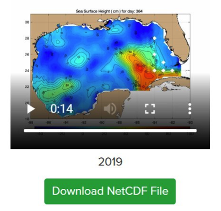
Did you know that GCOOS has been compiling data and distributing sea surface heights from the Colorado Center for Astrodynamics Research (CCAR) since 2004? CCAR's Robert Leben produces gridded data maps.
Sea surface heights (SSH) are affected by tidal forces, ocean circulation, and variations in the gravitational field. The daily variation from the mean sea surface height is the sea surface height anomaly (SSHa), which is observed by satellite altimeters, and what is distributed by GCOOS.
- The data are distributed in netCDF format and can be downloaded directly from https://geo.gcoos.org/ssh/.
-
These data will also be made available via GCOOS ERDDAP Server (erddap.gcoos.org/erddap). The latest data posted are the readings for January and February 2020. New data is posted as it becomes available.
|
|
National Report Highlights Respiratory Forecast |
|
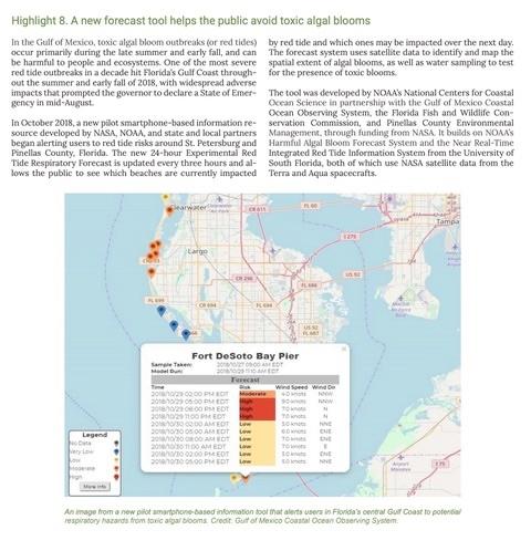
The annual report from the U.S. Global Change Research Program for FY2020 has highlighted the Red Tide Respiratory Forecast as a programmatic achievement helping to inform public decision-making during red tides. The forecast gives residents and visitors a tool that helps them assess what day and time to visit local beaches during red tides.
The Forecast was initially implemented in Pinellas County in 2018 thanks to a grant from NASA's Applied Science Program through the Health and Air Quality Program. It was developed by NOAA’s National Centers for Coastal Ocean Science (NOAA-NCCOS) in partnership with GCOOS and the Florida Fish and Wildlife Conservation Commission-Fish and Wildlife Research Institute (FWC-FWRI).
Today, the risk assessment forecast is implemented as red tide blooms warrant and covers 25 beaches along Florida’s Gulf coast, from Pinellas County south to Lee County.
|
|
Planning for Next Gen Satellite Capabilities |
|
In 2030, NOAA will launch its next generation of satellites through the geostationary and extended orbit (GEO-XO) program. Currently, NOAA is working to understand the needs of the end-user community and identify how remotely sensed data are used.
One area of focus is understanding the needs of the human health community and the agency is asking those in the health sector to take the “GEO-XO Human Health Workshop Community Survey.”
|
|
Global Oceans 2020 Agenda |
|
The agenda for Global OCEANS 2020: Singapore — U.S. Gulf Coast is packed with technical sessions, educational tutorials & workshops, and outstanding plenaries.
During this virtual conference, global thought leaders and innovators in marine technology, engineering, science, research, and education will gather to learn and experience cutting-edge technologies in marine science, hear from industry experts and engineers about the latest research and innovations, discuss current environmental issues and policies, and collaboratively work together to move the fields of marine technology and engineering forward.
|
|
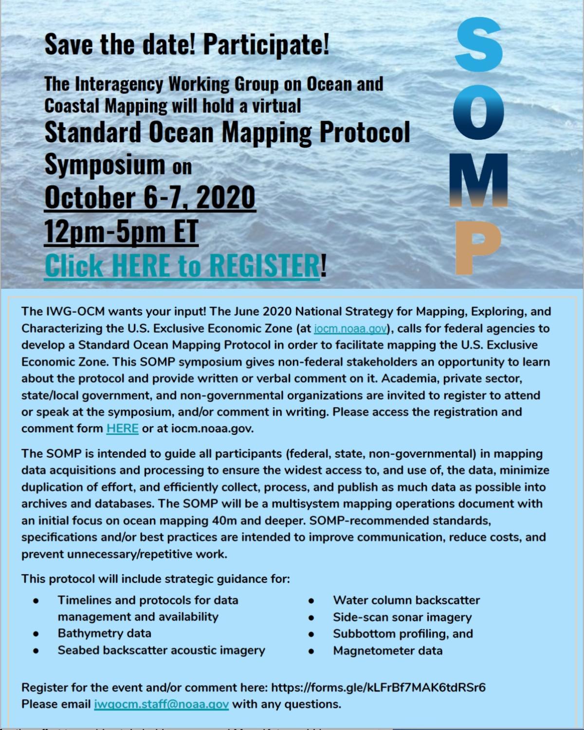
Input Sought on Ocean Mapping Protocols |
|
The Interagency Working Group on Ocean and Coastal Mapping will hold a virtual Standard Ocean Mapping Protocol Symposium in October.
Federal agencies are required to develop a Standard Ocean Mapping Protocol to facilitate mapping the U.S. Exclusive Economic Zone. This symposium gives non-federal stakeholders an opportunity to learn about the Protocol and provide written or verbal comments. Academia, private sector, state/local government, and non-governmental organizations are invited to register to attend or speak at the symposium, and/or comment in writing.
|
|
The Caribbean Coastal Ocean Observing System (CARICOOS) is seeking expressions of interest (EOIs) for collaborations on the operation, maintenance, enhancement, and outreach of the program. They welcome submissions from academic institutions, profit and non-profit organizations, and federal & state governments. Projects that augment the reach of CARICOOS data and products are especially encouraged.
|
|
Healthy Ecosystems & Living Resources |
|
GCOOS Webinar Series Presents: MBON: Integrating, Centralizing Biological Data |
|
One of the most important first steps in creating our national and international ocean observing systems was developing a common data language so that knowledge could be shared freely and broadly to improve everything from weather prediction to maritime commerce to public safety and national security.
Nearly two decades later, the focus is on assimilating biological data as ocean observing systems address how to make seemingly disparate information, gathered on different spatial and temporal scales, using different methods and stored in different ways, interoperable.
There are six Marine Biodiversity Observation Network (MBON) projects under way to advance development of a coherent, coordinated biological observing system to assess the state of the ocean’s animals and ecosystems. GCOOS, a partner on the South Florida MBON project led by Dr. Frank Muller-Karger, University of South Florida, is helping to pave the way to speak a common biology language so that information can be applied to more effectively protect and restore healthy coastal ecosystems and enable the sustained use of marine resources.
“The combined measuring of physical and biological data on the same scales can help understand and predict future changes as one or more variables in the system change,” says GCOOS Senior Research Associate Marion Stoessel, an integral part of the team who has translated volumes of fisheries data into a common language so that others can incorporate it into their research. “For example, how might changes in salinity or temperature affect the biological environment?”
|
|
You can learn more about MBON in the next episode of the GCOOS Webinar Series with optical oceanographer Dr. Dan Otis, from the University of South Florida College of Marine Science Institute for Marine Remote Sensing.
Dr. Otis will showcase two web-based portals with satellite products developed to alert Flower Garden Banks and Florida Keys National Marine sanctuaries staff to anomalous oceanographic conditions.
As part of the South Florida Marine Biodiversity Observation Network team, his work is contributing to a better understanding of biodiversity and the ocean conditions driving species composition, abundance, distribution and trends.
|
|
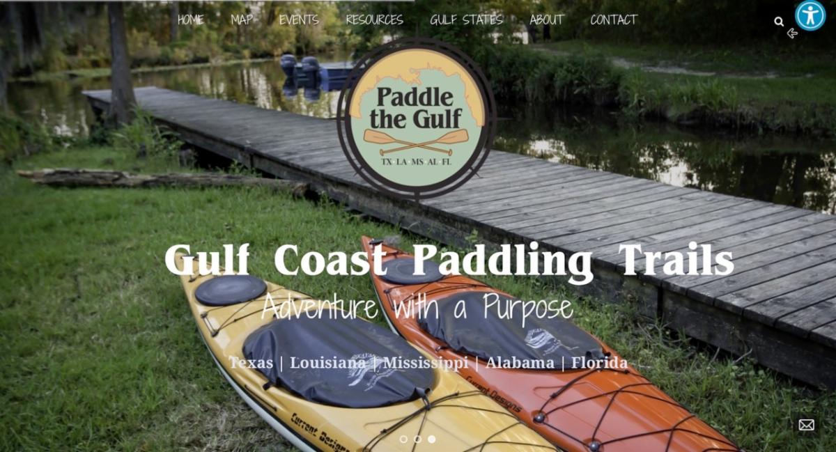
New Paddle the Gulf Website is Live |
|
The Gulf of Mexico Alliance has launched its new Paddle the Gulf website — a new go-to paddling resource for experienced and novice paddlers alike.
The site showcases coastal paddle trails — known as blueways — across the five U.S. Gulf states and is a starting point to learning about local water trails, upcoming events, and ways to join citizen science initiatives. GCOOS is a partner on the project.
|
|
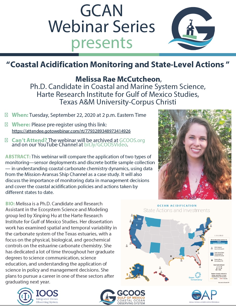
GCAN Webinar Series Presents: Coastal Acidification Monitoring and State-Level Actions
|
|
The Gulf of Mexico Coastal Acidification Network is pleased to present its next webinar with Melissa Rae McCutcheon, Ph.D. Candidate in Coastal and Marine System Science, Harte Research Institute for Gulf of Mexico Studies, Texas A&M University-Corpus Christi.
During her presentation, McCutcheon will compare the application of two types of monitoring — sensor deployments and discrete bottle sample collection — in understanding coastal carbonate chemistry dynamics using data from the Mission-Aransas Ship Channel as a case study. The webinar will also discuss the importance of monitoring data in management decisions and cover the coastal acidification policies and actions taken by different states to date.
|
|
Tracking Hurricane Activity in the Gulf |
|
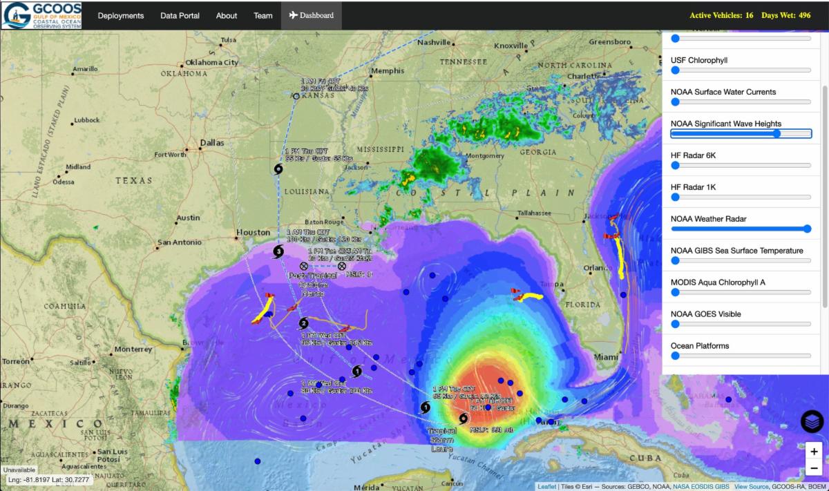
Our glider data portal, GANDALF, has certainly been busy this year.
Right now, we’re tracking 16 autonomous underwater vehicles and dozens more Argo floats and sharing their data on conditions in the Gulf and the Caribbean Sea.
For the first time, there are six active gliders in the Gulf, covering much of the area with east-west tracks — quite possibly a record, especially during hurricane season!
Interested in what the data's showing as Sally stalls out in the northern Gulf? Or what might be happening in the Caribbean?
|
|
The National Academies Gulf Research Program recently appointed the ad-hoc committee for the Oil in the Sea IV: Inputs, Fates, and Effects consensus study to update a 2003 report. The committee will hold its first public meeting virtually to explore the study’s statement of task with sponsors and other invited stakeholders.
|
|
Economic Outcomes from HAB Events |
|
The Gulf of Mexico Alliance Water Resources Team partnered with economists at the Balmoral Group to understand the financial impacts of harmful algal blooms. The project quantified the link between economic outcomes and Gulf of Mexico coastal health, focusing on Lee, Collier, Pinellas, Charlotte, Sarasota, Manatee, and Hillsborough counties on Florida’s Gulf Coast. The team compiled their results with GIS data and created an enhanced temporal resolution of HAB data.
|
|
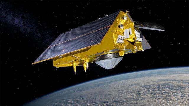
Satellite Mission to Improve Hurricane Forecasting, Climate Science |
|
A new satellite designed to capture detailed measurements of sea-surface height and other ocean features is scheduled to launch Nov. 10. The Sentinel-6 Michael Freilich satellite is designed to help provide enhanced hurricane intensity forecasts and improved information of Earth’s climate, NOAA says.
Sentinel-6 Michael Freilich will be the fourth in a 28-year series of ocean altimeter missions, which include TOPEX/Poseidon – Jason-1, OSTM/Jason-2 and Jason-3. Data from the mission will be critical in NOAA's efforts to track sea-level rise, study tsunami dynamics, the El Niño Southern Oscillation, and more accurately predict hurricane intensity. We talked with Eric Leuliette, NOAA's program scientist for Sentinel-6 Michael Freilich about the agency's planned use of the data.
|
|
In 2010, the explosion of the Deepwater Horizon resulted in the largest man-made disaster in U.S. history. Today, each Gulf state administers restoration funds and programs. Additionally, other agencies and organizations are also tasked with administering programs designed to restore Gulf habitats and better understand Gulf ecosystems.
|
|
GCOOS maintains a jobs listing for positions and fellowships in the ocean observing community. Want to advertise a position? Email Laura Caldwell
|
-
National Academies of Sciences, Engineering and Medicine (NASEM) Gulf Research Program: Environmental Program Director; Board on Offshore Energy and Safety Director; Board on Education and Engagement Awards Specialist
-
Clearwater Marine Aquarium Research Institute: North Atlantic Right Whale Aerial Survey Team Leader and Observer
-
Mote Marine Laboratory: Senior Research Scientist in Shark or Manatee Biology, Staff Analytical Chemist, Exotoxicology Program; Florida Red Tide Initiative Postdoctoral Scientist; Coral Restoration Postdoctoral Researcher;
-
Florida International University: Open-rank faculty position in Phycology
-
Genwest Systems, Inc.: GIS Analyst
-
The Water Institute of the Gulf: Data Architect for Environmental Resources
-
Flanders Marine Institute (VLIZ): Science Officer Genetic Data
Postdoctoral Positions:
- NOAA: National Centers for Coastal Ocean Sciences, NRC Research Programs
Fellowships:
- Margaret A. Davidson Graduate Fellowship
|
|
GCOOS maintains a listing of funding opportunities. Have an opportunity you'd like to advertise? Email Laura Caldwell
|
- FY 2020 Ocean Technology Transition Project
- NOAA Office of Ocean Exploration and Research FY2021 Federal Funding Opportunity
- Gulf of Mexico Alliance Funding Calendar
- ROSES-20 Amendment 30: Ocean Salinity Field Campaign Final Text and Due Dates
|
|
18, 21-25 & 30: Ocean Best Practices Workshop IV Virtual |
|
5-20: Oceans 2020 Gulf Coast and Oceans 2020 Singapore have been combined into a virtual conference featuring a mix of live and on-demand events. Details. See list of Gulf presenters.
|
|
1-3: Bays and Bayous Symposium, Golden Nugget Biloxi Hotel and Casino in Biloxi, Mississippi. “Sound Science, Sound Policy: A 2020 Vision for the Future." Begins at noon on Tuesday, Dec. 1; ends at noon on Thursday, Dec. 3
|
|
GCOOS is the Gulf of Mexico regional component of the U.S. Integrated Ocean Observing System (IOOS) and the only certified system dedicated solely to the Gulf of Mexico. Our mission is to provide timely, reliable and accurate information on the open ocean and coastal ocean waters of the Gulf of Mexico to ensure a healthy, clean, productive ocean and resilient coastal zone. |
|
Dr. Barbara Kirkpatrick, Executive Director • Bill Lingsch, U.S. Glider User Group Coordinator • Dr. Chris Simoniello, Outreach & Education Coordinator • Felimon Gayanilo, Systems Architect • Dr. Shinichi Kobara, Assistant Research Scientist, Product Developer • Bob Currier, Research Specialist, Product Developer • Marion Stoessel, Senior Research Associate • Dr. Steven Baum, Associate Research Scientist • Jennifer Vreeland-Dawson, Research Associate • Grant Craig, Program Coordinator • Nadine Slimak, Public Relations & Content Marketing, Vetted Communications, LLC • Dr. Chuan-Yuan Hsu, Post Doctoral Research Associate • Robbie Iles, Graduate Research Assistant • Laura Caldwell, Program Assistant
|
|
In Memoriam: Matt Howard, 1952-2018
|
|
|
|
|
|
|