
|
GCOOS is the Gulf of Mexico regional component of the U.S. Integrated Ocean Observing System (IOOS). Our mission is to provide timely, reliable and accurate information on the open and coastal ocean waters of the Gulf of Mexico to ensure a healthy, clean, productive ocean and resilient coastal zone.
|
|
|
|
June 2017 - In This Issue:
|
|
|
|
|
Greetings!

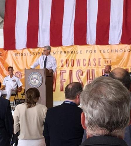
This month we had the pleasure of showcasing GCOOS during the MSET Technology Showcase and Crawfish boil held in conjunction with the Naval Oceanography Unmanned Systems Operational Demonstration on June 1. The technology showcase, held at the Air National Guard's Combat Readiness Training Center in Gulfport, included exhibitors from academia, government and unmanned vehicle vendors.
It was a great way to showcase the benefits that GCOOS provides for data collection and distribution in the Gulf and increase awareness about our organization.
A special thanks to Stephan Howden, GCOOS Board Member/ University of Southern Mississippi and Bill Lingsch, GCOOS Board Chairman/Vencore Services and Solutions, Inc. for their help with our booth set up and introductions. New GCOOS Board Member Kirsten Larsen,
Lead Oceanographer for NOAA's National Centers for Environmental Information in Mississippi also attended. Speakers at the event included Monty Graham, GCOOS Member and Director of the University of Southern Mississippi's new School of Ocean Science and Technology, Mississippi Gov. Phil Bryant and Sen. Roger Wicker, (R-Miss.). Congratulations also go out to Monty and USM, which awarded its first 15 certifications to stu
dents in Tier 1 of USM's new Unmanned Maritime Systems program during the event.
Until next month!

|
|
|
Nadine Slimak, Public Relations & Content Marketing, Vetted Communications, LLC
|
|
|
|
Pictures from MSET Technology Showcase
|
|
|
|
Stephan Howden, Barb Kirkpatrick
|
|
Gov. Phil Bryant
|
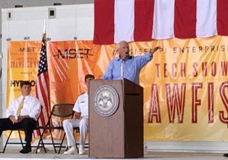
Sen. Roger Wicker
|
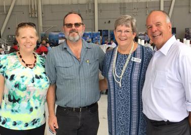
Kirsten Larsen, Stephan Howden,
Barb Kirkpatrick, Monty Graham
|
|
|
|
 |
|
|
Buoy locations
|
On June 6, the National Centers for Environmental Information (NCEI) and GCOOS completed a joint project to archive data automatically from GCOOS. The first dataset archived under the new automated process is titled "Oceanographic and surface meteorological data collected from station Bon Secour, LA, by Dauphin Island Sea Laboratory (DISL) and assembled by Gulf of Mexico Coastal Ocean Observing System (GCOOS) in the Coastal waters of Alabama and Gulf of Mexico from 2011-01-01 to 2017-05-02 (NCEI Accession 0163204 and 0163213)."
The archived data contains oceanographic and surface meteorological data in netCDF formatted files, which follow the Climate and Forecast Metadata Conventions (CF) and the Attribute Convention for Data Discovery (ACDD). DISL collected the data from seven in-situ moored stations in the northern Gulf of Mexico. GCOOS, which assembles data from DISL and other sub-regional coastal and ocean observing systems of the Gulf of Mexico Coastal United States, submitted the data to NCEI as part of the Integrated Ocean Observing System Data Assembly Centers (IOOS DACs) Data Stewardship Program.
Data from other providers in the region that gave GCOOS the authority to archive their data in NCEI are being processed and will be made available to NCEI for archiving as soon as it completes an internal quality check of all the data submitted to the data portal.
|
PLOS One Paper Adapted for Kids
|
 A paper on reef fish spawning in the Southeastern U.S. that was published in the peer review journal PLOS One has now been adapted for high schoolers and published in Science Journal for Kids. A paper on reef fish spawning in the Southeastern U.S. that was published in the peer review journal PLOS One has now been adapted for high schoolers and published in Science Journal for Kids.
The PLOS One paper, "Timing and locations of reef fish spawning off the southeastern United States," considered peak spawning and generated predictive maps for gray triggerfish, white grunt, red snapper, vermilion snapper, black sea bass and scamp and identified locations where reconfiguration or expansion of existing marine protected areas would afford spawning reef fish greater protections. The study also recommended increased sampling off southern Florida during certain times of the year.
The paper was published by lead author Nicholas A. Farmer, NOAA/NMFS, with coauthors William D. Heyman and Kyle McCain, LGL Ecological Research Associates, Inc.; Mandy Karnauskas, NOAA/NMFS; Shinichi Kobara, GCOOS/Texas A&M University College Station; Tracey I. Smart, Joseph C. Ballenger, Marcel J. M. Reichert and David M. Wyanski, South Carolina Department of Natural Resources; Michelle S. Tishler, Meadows Ecological, Inc.; Kenyon C. Lindeman, Florida Institute of Technology; Susan K. Lowerre-Barbieri, Theodore S. Switzer and Justin J. Solomon, Florida Fish and Wildlife Conservation Commission; Mark Marhefka, Abundant Seafood and George R. Sedberry, NOAA Office of National Marine Sanctuaries.
The Science Journal for Kids article, "How Can We Protect Fish Better?" includes key terms, scientific methods, AP Environmental Science Topics, a teacher's key and videos.
|
First Unmanned Systems Demo
|
|
|
|
Fleet Survey Team Survey Technician AG2 Jesse Osborne operates an Iver3 unmanned system via radio frequency remote during compass calibration mission in the Gulf of Mexico in preparation for bathymetric data collection in support of Naval Oceanography Unmanned Systems Operational Demonstration Humanitarian Assistance/Disaster Relief support scenario.
|
More than 300 people attended the first Naval Oceanography Unmanned Systems Operational Demonstration May 31-June 2 hosted by Commander, Naval Meteorology and Oceanography Command (COMNAVMETOCCOM) at the Combat Readiness Training Center-Battlefield Airmen Center in Gulfport, Mississippi.
"Naval Oceanography has over two decades of experience operating unmanned systems," said COMNAVMETOCCOM and Oceanographer of the Navy Rear Adm. Tim Gallaudet. "The purpose of the demonstration was to build on that experience by expanding and strengthening our network of partners to innovate faster so we can make better decisions quicker than our adversaries."
To simulate Navy missions for the demonstration and test unmanned systems capabilities, the participants performed Fleet mission areas such as Humanitarian Assistance/Disaster Relief (HA/DR); Sea Control; Theater Anti-submarine Warfare (ASW); Intelligence, Surveillance and Reconnaissance (ISR); as well as a Cyber Challenge and an Unmanned Maritime Systems Certification program.
COMNAVMETOCCOM directs and oversees more than 2,500 globally-distributed military and civilian personnel who collect, process and exploit environmental information to assist Fleet and Joint Commanders in all warfare areas to make better decisions faster than the adversary.
|
First USM Unmanned Systems Certifications Awarded
|
|
|
|
During the Naval Oceanography Unmanned Systems Operational Demonstration in Gulfport, Miss., Rear Adm. Tim Gallaudet and The University of Southern Mississippi President Rodney D. Bennett presented Tier 1 certifications to 15 students. |
The University of Southern Mississippi made history on June 1 with 15 students completing a first-of-its-kind certification in Unmanned Maritime Systems (UMS).
"This is akin to what NASA first did with spaceflight," Rear Admiral Timothy Gallaudet said. "This class should be mighty proud because the national impact of this certification and the skills taught throughout the course will be felt for decades."
The UMS program spanned an intensive five weeks with students studying nautical science, 3-D positioning, ocean policy and autonomous systems. "This program was designed to provide a rigorous, hands-on academic program to introduce the students to unmanned maritime systems and the decision processes needed to operate them, " said Monty Graham, Director of USM's School of Ocean Science and Technology. "Students developed skills in disciplines such as electronics, programming, policy and application."
The 15 students included civilian and military personnel from the Naval Oceanographic Office, Fleet Survey Team and Naval Oceanography Mine Warfare Center at the John C. Stennis Space Center; Submarine Development Squadron 5 in Bangor, Washington; Naval Oceanography Special Warfare Center in San Diego; the National Oceanic and Atmospheric Administration in Norfolk, Virginia; and the Naval Undersea Warfare Center based in Newport, Rhode Island. The class instructor was Dr. Vernon Asper. The UMS class finished the first tier in a three-tier program. Students going through the entire tier structure will earn a full graduate degree.
|
|
Assessing Protected Species in the Gulf
|
The Bureau of Ocean Energy Management (BOEM) is funding and participating
 in a federal research partnership that has launched an intensive three-year program to improve assessment studies of protected marine species in the Gulf of Mexico. The initiative is using aerial surveys, ship-based surveys and satellite tagging to collect the best information possible on the abundance and distribution of marine mammals, seabirds and sea turtles in the Gulf to inform federally mandated environmental assessments related to offshore energy and marine minerals development.
The partnership, known as the Gulf of Mexico Marine Assessment Program for Protected Species (GoMMAPPS), was recently finalized through signed agreements between BOEM, NOAA Fisheries, the U.S. Fish and Wildlife Service Southeast Region and the U.S. Geological Survey's Wetlands and Aquatic Research Center. The initiative is officially recognized as a research partnership through the National Oceanographic Partnership Program (NOPP).
|
| The National Academies Keck Futures Initiative (NAKFI) and the Gulf Research Program -- programs of the National Academies of Sciences, Engineering, and Medicine -- announced recipients of 21 interdisciplinary seed grants, totaling $1.55 million. These competitive grants support collaborations and investigations resulting from Discovering the Deep Blue Sea: Research, Innovation, Social Engagement, the 14th annual Futures conference, held last November.
|
|
New Citizen Science Smartphone App for Red Tide Reports
|
 Smartphone users can now download a new app to self-report impacts of Florida red tide algae (Karenia brevis), thanks to Mote Marine Laboratory's project to engage citizen scientists along Florida's Gulf of Mexico coast. Smartphone users can now download a new app to self-report impacts of Florida red tide algae (Karenia brevis), thanks to Mote Marine Laboratory's project to engage citizen scientists along Florida's Gulf of Mexico coast.
The free app, Citizen Science Information Collaboration (CSIC), allows users to report when and where they experience respiratory irritation or see discolored water or dead fish -- all potential indications of Florida red tide. This summer and later, Mote scientists plan to add multiple other reportable environmental conditions beyond red tide impacts.
"We're doing this to obtain new data streams while empowering the public and putting the reporting in their hands," said Dr. Tracy Fanara, manager of Mote's Environmental Health Program.
Fanara worked with Dr. Vincent Lovko, manager of Mote's Phytoplankton Ecology Program, and web development contractors at Function on Phones to create the app. The concept was informed by a project completed by a former Mote intern and through discussion with collaborators from the Harmful Algal Bloom group at the Florida Fish and Wildlife Conservation Commission-Fish and Wildlife Research Institute.
- Search for "Mote CSIC" in the app store
|
|
New New Regional Shellfish Initiative
|
Mississippi-Alabama Sea Grant has started a new Gulf of Mexico Shellfish Initiative (or GoMexSI) -- an ambitious effort to increase shellfish populations through restoration, traditional fisheries
 and aquaculture throughout the region. With funding from the
Gulf States Marine Fisheries Commission, the planning team will seek input from stakeholders in Gulf each state -- through small groups, an online survey, in-person and phone interviews -- to identify common goals among the Gulf states, and goal that are are unique to each state.
GoMexSI will help strengthen future partnerships among groups and provide potential leverage for funding to complete goals.
|
C-IMAGE Launches Beneath the Horizon Interactive Website
|

On April 20, 2017, the seventh anniversary of the Deepwater Horizon oil spill, the Center for the Integrated Modeling and Analysis of the Gulf Ecosystem (C-IMAGE) launched a new website called Beneath the Horizon. The interactive site shares impacts, timelines, stories, videos and interviews from the Ixtoc-I oil spill in 1979 and the Deepwater Horizon oil spill in 2010. The site also includes links to many of C-IMAGE's podcast episodes from their series, The Loop. The site will eventually include lesson plans and outreach materials.
|

The 10-year, $500 million, independent research program was established by an agreement between BP and the Gulf of Mexico Alliance to study the effects of the Deepwater Horizon incident and the potential associated impacts of this and similar incidents on the environment and public health.
In addition to news about GoMRI activities, the newsletter also offers a listing of the latest GoMRI publications, including news of larval fish health, trends and gaps in oil-spill related literature, Corexit effects and more.
|
|
MDEQ Restoration Contracting Workshop
|
 The Mississippi Department of Environmental Quality's Office of Restoration and Office of Community Engagement Small Business Environmental Assistance Program (SBEAP) are offering a workshop on restoration contracting. The workshop will provide information regarding the necessary requirements for pursuing restoration contracting opportunities and businesses will have the opportunity to meet face-to-face with MDEQ procurement officers, the Mississippi Development Authority and the U.S. Small Business Administration. The Mississippi Department of Environmental Quality's Office of Restoration and Office of Community Engagement Small Business Environmental Assistance Program (SBEAP) are offering a workshop on restoration contracting. The workshop will provide information regarding the necessary requirements for pursuing restoration contracting opportunities and businesses will have the opportunity to meet face-to-face with MDEQ procurement officers, the Mississippi Development Authority and the U.S. Small Business Administration.
- 1 p.m. to 5 p.m. Thursday, July 13
- Gulf Coast Event Center, 9475 Highway 49, Gulfport, MS, 39503
- Pre-registration is required by July 6.
- More info & registration
|
|
GOMA Announces Coastal Resilience Awards
|
 The Gulf of Mexico Alliance announced Coastal Resilience Awards for eight community projects totaling $347,334. The awards are supported by funding from the NOAA Office for Coastal Management. The Gulf of Mexico Alliance announced Coastal Resilience Awards for eight community projects totaling $347,334. The awards are supported by funding from the NOAA Office for Coastal Management.
The Alliance created an opportunity for Gulf Coast communities to submit project ideas that address a resilience need or gap identified through a vulnerability assessment. Awardees include communities in Florida, Mississippi, Louisiana and Texas. A competition is under way in coastal Alabama with plans to announce an awardee there by August.
As the selected communities take steps to enhance their resilience, they will become part of a Resilience Community of Practice. Here, they will share their experiences with their peers and establish best practices from which others may learn.
|
Restoration Funding Calendar
- NOAA RESTORE Act Science Program hosts a three-year calendar that consolidates planned funding opportunities
By State:
|
|
New Reports and Good Reads
|
Important Update: New Coast Pilot Covering the Gulf Released
|
 The National Ocean Service and NOAA have published the 45th edition of the United States Coast Pilot 5, covering the Gulf of Mexico, Puerto Rico and the Virgin Islands. The National Ocean Service and NOAA have published the 45th edition of the United States Coast Pilot 5, covering the Gulf of Mexico, Puerto Rico and the Virgin Islands.
This document provides important supplemental information to the NOAA Nautical Charts. Much of the content cannot be shown graphically on the charts and is not readily available elsewhere.
Topics covered include environmental factors of weather, climate, ice conditions, tides, water levels, currents, prominent coastal features and landmarks. Specific information on vertical clearances, wharf descriptions, small-craft facilities, hazards, dredged channels and depths are also provided. Navigation services and regulations are also identified including pilotage, towing, anchorages, routes and traffic separation schemes, environmental protection and other Federal laws.
|
Gulf Ecosystem Status Report Update
|
 NOAA has released an update to the Gulf of Mexico Ecosystem Status Report. Originally published in 2013, the report summarized focal components in the Gulf of Mexico necessary to consider from an ecosystem perspective and highlighted potential indicators -- including climate drivers, biological states, and socioeconomic responses -- that could be used to track these focal ecosystem components. NOAA has released an update to the Gulf of Mexico Ecosystem Status Report. Originally published in 2013, the report summarized focal components in the Gulf of Mexico necessary to consider from an ecosystem perspective and highlighted potential indicators -- including climate drivers, biological states, and socioeconomic responses -- that could be used to track these focal ecosystem components.
The 2017 update highlights a subset of refined indicators and additionally includes a suite of human dimensions indicators intended to track the well-being of communities dependent on the Gulf of Mexico ecosystem.
|
A NEW 1.4-Billion-Pixel Map of the Gulf of Mexico Seafloor
|
|
|
|
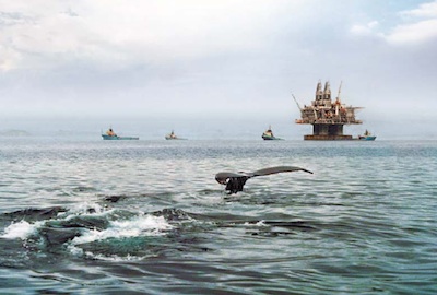
A new bathymetry map, created by integrating many
3-D seismic surveys, reveals the Gulf of Mexico's seafloor in unprecedented detail. Above is a snippet of this map -- roughly 220 kilometers wide -- showing the central Gulf of Mexico's complex morphology of salt domes and minibasins. Credit: BOEM
|
K. V. Kramer and W. W. Shedd report in
Eos Earth and Space Science News
that the U.S. Bureau of Ocean Energy Management (BOEM) has released the highest-resolution bathymetry map of the Gulf region to date. The new regional seafloor dataset reveals a dynamic environment with stunning new clarity, including detailed seismic surveys originally shot by 15 different companies involved in the oil and gas industry. BOEM gained permission to release the relevant proprietary data publicly in a freely downloadable aggregate map of the seafloor.
The most popular bathymetry map of the northern Gulf of Mexico has been the version generated in the 1990s by NOAA, the National Geophysical Data Center (NGDC), and GCOOS. The organizations compiled it using data from various multibeam sonar surveys and 2-D seismic lines spaced kilometers apart, providing a resolution of up to 2,500 square meters per pixel. This is excellent resolution, geophysically speaking, and for the past two decades, the map has been a respected and popular regional dataset within science, academia and the oil and gas industry.
BOEM's new map, derived exclusively from 3-D seismic data, doesn't cover as large an area as the NOAA/NGDC/GCOOS map, but its enhanced resolution and consistent pixel size reveal undiscovered and previously poorly resolved geologic features over the continental slope, salt minibasin province, abyssal plain, Mississippi Fan and the Florida Shelf and Escarpment. However, because of the new map's smaller coverage, the historic map will continue to be very useful.
|
Louisiana Coastal Restoration Plan Moves Forward
|
The 2017 rewrite of Louisiana's $50 billion, 50-year plan for coastal restoration and hurricane storm surge protection, and the $644 million budget for its fiscal 2018 projects, were both approved by the state House of Representatives on Friday (June 2). Having already been endorsed by the Senate, both measures now go to Gov. John Bel Edwards for his certain signature.

|
Office of Coast Survey; Three Vacancies
|
The Office of Coast Survey has three vacancies within the Coastal Marine Modeling Branch in the Coast Survey Development Laboratory. These positions are for a Physical Scientist at either the ZP-3 or 4 level and open to both internal and external applicants . The deadline to apply has been extended to June 20.
Search USAjobs under the following announcement numbers:
- Announcement Number: NOS-OCS-2017-0018 (MAP)
- Announcement Number: NOS-OCS-2017-0020 (DE)
|
June
June 18-23, 2017, Stonehill College, Easton, Mass.
The 2017 Gordon Research Conference (GRC) on Mycotoxins and Phycotoxins will provide a forum for academic, government and private sector scientists to exchange ideas on harnessing advances in biology, chemistry, ecology, plant pathology, epidemiology and risk assessment to address the problems associated with occurrence of these natural toxins.
September
International Radiowave Oceanography Worshop, September 19-21, 2017 in Luneburg, Germany. The successful series of the international Radiowave Oceanography Workshop (ROW) has focused on the scientific aspects of ocean applications of high frequency radars. ROW 2017 is the next in this series and will provide a forum for researchers to discuss their results, swap data and algorithms, and identify priorities for future research.
If you would like to participate please refer to the registration section. See the Important dates.
October
GCOOS BOD/Members Meeting, October 11-13, 2017, Mobile, AL.
IOOS Advisory Committee Meeting, October 24-26, 2017.
|
|
Share Your News with GCOOS
|
Do you have a meeting, job or funding announcement? Please let us know so we can help spread the word. Email info, including all pertinent details and website links, to Laura Caldwell, GCOOS Staff Assistant, [email protected].
Are you starting or finishing a research project, reporting new findings, have a new publication or other big news to share with the GCOOS community? Please email our Public Relations and Content Coordinator, Nadine Slimak at Vetted Communications, [email protected].
|
|
|
|
|


