|
Dear Friends and Neighbors:
Tomorrow City Council will vote on revisions to Chapter 19 of the Houston Code of Ordinances which regulate building in the floodplain. This is an important vote as the revised ordinance will affect hundreds of thousands of home and business owners throughout Houston. The exact economic impact is unknown, but undoubtedly will be great. As of now, I am inclined to vote NO. My reasons and explanations are set forth below.
When looking at these revisions that seem applicable to our current situation, there comes to mind a few adages. One is "measure twice, cut once." Another is "haste makes waste." Finally, my favorite, "when you move, move with a purpose." Each of these sums up what is exactly wrong with the city's approach to revising Chapter 19. We are not heeding the wisdom contained therein. With more time to study the issues, we might better be able to succeed at the revisions' purpose without encompassing properties outlying the real areas of concern. Simply, in my opinion, we are unnecessarily overreaching.
I. Chapter 19 (Floodplain Ordinance): Overview
A. Definition of Floodplain
The Federal Emergency Management Administration (FEMA) defines a floodplain as any land susceptible to being inundated by floodwaters from any source. This can include coastal areas impacted by storm surges, land along a river or bayou that is flooded when that waterway rises out of its banks, or low-lying land that fills with water when it rains.
In addition to describing a natural phenomenon, a floodplain is a legally defined concept. FEMA designates floodplains nationwide for several purposes:
- cities set special building regulations for properties inside the designated floodplain;
- designated floodplains are used to set rates for flood insurance; and
- mortgage issuers require flood insurance for any property in the designated floodplain.
Floodplains are usually designated as 100-year floodplains as well as 500-year floodplains. The 100-year (1%) floodplain is land that is covered in water during a flood event that has a 1 percent chance of being equaled or exceeded in any given year. The 500-year (.2%) floodplain is land that is covered in water during a flood event that has a 0.2 percent chance of being equaled or exceeded in any given year. This doesn't mean that those within the floodplains will only flood once in the 100- or 500-year period; rather, in any given year, the chance of flooding is 1% or .2% respectively. Areas within the 100-year floodplain may flood in much smaller storms as well.
B. Purpose
Communities adopt reasonable and effective floodplain ordinances for the reasons set forth below. Communities are required to adopt an ordinance that meets the minimum standards of
44 C.F.R.
§§ 59-72 if they wish to participate in the National Flood Insurance Program (NFIP) and have flood insurance available.
NFIP underwrites flood insurance coverage only in communities that adopt and enforce floodplain management regulations through an ordinance that meets or exceeds NFIP criteria.
The purposes of the floodplain regulations are to:
- protect life, health and property;
- minimize public expenditures for costly flood control projects;
- minimize rescue and relief efforts;
- minimize business interruptions;
- minimize damage to public facilities;
- minimize the occurrence of future flood blight areas;
- discourage the victimization of unwary land and home buyers; and
- prevent increases in the regional flood from occurring.
C. Reason For Change
Hurricane Harvey served as a catalyst for the city to re-examine its building regulations in the floodplain. The proposed new rules which will apply BOTH to the 100-year (1%) floodplain AND the 500-year (.2%) floodplain are drafted in anticipation of the new FEMA Flood Insurance Rate Maps (FIRM) that will be proposed as a result of the Atlas 14 initiative. Atlas 14 is based on the studies of
National Oceanic and Atmospheric Administration's (NOAA) Hydrometeorological Design Studies Center (HDSC). NOAA is updating precipitation frequency estimates for various parts of the United States and affiliated territories, which are published as volumes of NOAA Atlas 14 (NA14). HDSC is currently updating estimates for the state of Texas that will be published in 2018.
In other words, the Chapter 19 revisions are being proposed in anticipation of what we THINK the new maps will look like when they finally are issued. There is not any definitive time frame by which the FIRM will be issued. We have estimates that such remapping will occur anywhere from 18 months to three years from now.
D. Current Chapter 19
Currently, Chapter 19 ONLY applies to the 100-year (1%) floodplain. Currently only properties in the 100-year floodplain (1%) are regulated while properties in the 500-year floodplain (.2%) are not. The current elevation required for the 100-year floodplain (1%) is the 100-year elevation plus 1 foot. Further, zero net fill is required only of the 100-year (1%) floodplain. The current ordinance can be found in its entirety at
https://library.municode.com/tx/houston/codes/code_of_ordinances?nodeId=COOR_CH19FLPL
E. Proposed Revisions to Chapter 19
The proposed revisions will apply the rules and regulations of Chapter 19 to ALL properties within the 500-year (.2%) flood plain as well as the 100-year (1%) floodplain. It would require all new homes and buildings constructed within the 100-year and 500-year floodplains to be built to the elevation of 500-year plus 2 feet. The no net fill requirement will apply to those within both floodplains, unless there is a study showing no impact to natural flow of water. Not only does the ordinance apply to all NEW homes and buildings, but also to any additions to current structures in the 500-year floodplain if the addition is 1/3 or more of the footprint of the structure. The revised ordinance can be found in its entirety at
http://www.houstontx.gov/council/g/chapter19/proposed-revisions-march23.pdf
F. Comparison Chart
|
RULES
|
EXISTING CH. 19
|
PROPOSED CH. 19
|
|
REGULATED AREA
|
100-year
|
100 + 500-year
|
|
ELEVATION
|
100-year + 1 foot
|
500-year + 2 feet
|
|
ZERO NET FILL
|
100-year
|
100 + 500-year
|
|
SUBSTANTIAL
IMPROVEMENTS
|
100-year
|
100-year
|
|
ADDITIONS IN
500-YEAR
|
N/A
|
Elevation required if more than 1/3 of footprint
|
|
ELEVATION OF
ADDITIONS
|
100-year + 1 foot
|
500-year + 2 feet
|
|
FOUNDATION
|
All types permitted outside floodway
|
All types permitted outside floodway
|
II. Concerns
A. What This Revision Will NOT Do
The proposed revisions to Chapter 19 aim to protect newly constructed structures by elevating them out of harm's way.
The revised ordinance does NOT add any detention or drainage projects. It will NOT reduce the likelihood of flooding to existing structures. It will NOT decrease the water level if a same or similar storm where to happen again. The ordinance does nothing to increase drainage, detention, or prevent flooding of the land. Rather, it will only require certain NEW structures be built above the current required levels. It doesn't solve the real problem of inadequate drainage infrastructure. Rather, it attempts to minimize elected leaders' failure to provide for such infrastructure improvements. While infrastructure improvements have real costs, so do these revisions.
B. Data
A main concern of mine is the lack of data used in the development of this new policy.
Out of 187,498 properties within the 100- and 500-year floodplains, just 31,822 properties, or 16.9 %, were studied. Of the properties studied, only 5,970 are in the 500-year floodplain, 2,456 of these in the Buffalo Bayou watershed. This means we are regulating the entire 500-year floodplain based on data representing only 6.96% of the properties contained therein. If you take out the properties studied in the Buffalo Bayou and San Jacinto watersheds, of which a large number flooded due to releases from dams or lakes, only 4% of properties affected in the 500-year floodplain were studied. Combined with the fact that only Hurricane Harvey was used to determine protection elevations, this data is hardly representative. While I understand the limitations placed on the study, those limitations could be resolved with additional time for data collection and expanded modeling.
There are 101,428 properties within the current 100-year floodplain of which 30,501 were impacted, not necessarily flooded, but impacted. This means 70,927 or 70% received no damage. There are 86,070 properties within the current 500-year floodplain of which 28,459 were impacted. This means 57,611 or 67% received no damage. Outside the floodplains, there are 469,634 properties of which 90,616 were impacted. Those affected outside the floodplains and not subject to this ordinance are almost twice the number of those affected within the floodplains and three times the number affected in the 500-year floodplain alone. If we are concerned about 28,459 properties, why aren't we concerned about the 90,616 properties for which this ordinance will do nothing? If there were no ramifications or costs involved in these regulations, it might not matter. However, it seems we will be regulating properties that don't need the regulations while not regulating properties that do need regulating. More time would allow for a deeper study of these properties which would undoubtedly result in a better understanding of the problems and the solutions.
A further concern regarding the data is that much of it is skewed due to the release from the two reservoirs, Barker and Addicks. In District G the number of Harvey-impacted properties in the 100- and 500-year floodplains and also outside the floodplains is shown below:
Total: 16,221
100-year: 1,729
500-year: 3,973
Outside floodplains: 10,519
As can be seen, most of the homes affected were outside the 100-year and 500-year floodplains. In fact, 64% fell outside the floodplains. Why? Because in District G the vast majority of homes were flooded due to the release of waters from the reservoirs, an event unlikely to occur again.
C. Overreach: New Maps
From discussions with the administration, the main reason for promulgating these new revisions appears to be to mirror what we expect the new 100-year floodplains to be when the new FIRM is issued. It is expected that the new 100-year floodplain will essentially be what is now the current 500-year floodplain. This may or may not be the case.
While it is certainly expected that the new 100-year floodplain will increase in size, it is not as simple as saying it will increase to the current 500-year level based upon the complex formula by which such a designation will occur. In fact, it is probably safe to say that some properties within the current 100-year floodplain will not remain within that designation and may not even be included in the 500-year floodplain. Meanwhile, some properties not currently in either floodplain will be added. In other words, we are just guessing now as to what the FIRM will look like, and that is the problem. Being included within the floodplain is not without costs. The key is who bears that cost and the one who bears that cost is the landowner. I explore that issue below.
The real problem occurs with the revision when the new maps (the FIRM) are released and the reality sets in as to who is now covered by this ordinance. As of now, only properties within the 100-year floodplain are covered. If this revision passes, then those within the 500-year will also be covered. While that in itself may be an overreach, it will be even more problematic when the FIRM is issued and those not currently within the 500-year floodplain suddenly find themselves covered under the new maps. In other words, there are landowners out there today which this ordinance does not and will not cover upon passage. However, they will be covered when the new maps sweep them into the new 500-year floodplain. The only way to cure this issue is to rollback the ordinance to its original intention once the new FIRM is issued. Not to do so is inexcusable as it ignores the actual intent and purpose for these revisions.
D. Costs
The larger problem with these revisions are the costs. Regulations always have costs. The issue is what are these costs exactly and who bears them?
As for who bears them, it is the property owner. The costs occur due to increased building requirements such as: (1) costs of testing; (2) costs of building (i.e., pier and beam); (3) costs due to compliance (raising one's building); or (4) diminution of property value for resale. This last cost should concern all of us including City Hall since such a loss in property value will hit our ad valorem taxes and result in reduced revenue for the city itself.
As for the costs, we don't know the costs and that is the problem. Over and over again, we asked for a determination of these costs. Over and over again, we were ignored or told the costs were not calculable. One group of experts came forward with calculations and said that such costs could amount to $32,000 per home for new homes requiring pier and beam rather than slab foundation. Ralph Bivins, former president of the National Association of Real Estate, in a 2014 article on Houston new home starts entitled "Boom on! Houston notches more new home starts than the entire state of California," estimated we would have 50,000 new home starts per year in Houston. Extrapolating such costs with the data, assuming housing starts remain robust, the cost of this ordinance for just new home starts approximates $1.6 billion. Of course, the real cost may be in the reduction of home sales as experts state for every $1,000 increase in housing costs, 4,000 qualified buyers are priced out. This would mean at least 128,000 potential homeowners would be priced out of homeownership. This increase and its resultant consequence would mean that we have an unaffordability issue when we are trying to improve housing affordability throughout all of Houston.
Other costs are for those of compliance and which can not be easily determined at this point. If a house is out of compliance with the ordinance, it may have to be raised to meet the requirements, such as if the property is substantially improved, an addition of any size is added within the 100-year floodplain, or the property is substantially damaged in a future flood event. In doing so, a property owner could incur upwards of $250,000 to raise his house based upon an average cost of such service at $150 per sq. ft. Such costs will only be realized in hindsight.
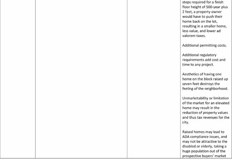
III. Pros & Cons
Below is a breakdown of the proposed revisions to Chapter 19 and the pros and cons of each major revision.
IV. Conclusions
While Chapter 19 should be revised to accurately reflect the changing dynamics of the city and those impacted by our most recent storms, such revisions should be based on comprehensive studies which take into account the economic impact on property owners and the city itself. By overreaching we risk sweeping up properties for which these regulations should not apply while ignoring others for which it should be applied.
While property owners stand to lose money based on increased new home prices, other property owners may see losses to property values on homes they already own. In doing so, the city of Houston risks its tax base, as appraisal rates and market forces drive down the properties values. Such effects may not be seen in the near future, but they most certainly will occur over time.
While not a perfect solution, a rollback to the 100-year floodplain upon the issuance of the new FIRM would help mitigate the unnecessary overreach and subsequent associated costs.
With more time, a better more comprehensive study would benefit not only property owners, but the city itself. Unfortunately, that does not appear possible for reasons unknown to me. Consequently, unless something changes between now and the vote, I am inclined to vote NO. Let me know if you agree or disagree. Text me at 832-627-8203.
-----------------------------------------------------------------------------------------------------------------------
If this email has been forwarded to you and you are not on our email list, you are invited to sign up here: Sign Up Here
____________________________________________________________
Greg Travis
Houston City Council Member, District G
900 Bagby, 1st Floor
Houston, TX 77002
Mailing:
P.O. Box 1562
Houston, TX 77251-1562
Phone: 832-393-3007
|