|
LCLUC Spring Newsletter : Issue No.7 |
We are happy to share recent updates from our Science Team Members and related research on Land Cover and Land Use Change.
This edition includes a detailed programmatic update from our Program Manager Dr. Garik Gutman, publications from our team and related projects, published meeting reports, and detailed information on our upcoming meetings. You will find information about our upcoming Spring Science Team Meeting and other LCLUC related meetings.
Be sure to check out the LCLUC mapper product on our website which shows the geographic distribution of principal investigators, project team members and geographic area of research projects.
We invite you to join our mailing list for future updates and to receive informa
tion about our webinar series.
Meghavi Prashnani
[Program Assistant] and
Chris Justice
[Program Scientist], and Garik Gutman [Program Manager]
|
|
|
|
Dr. Garik Gutman [Program Manager] |
Greetings for the New Year 2020. I would like to convey my best wishes to the whole LCLUC family and our friends around the world.
During the past 5 years, the geographic focus of the program has been on Asia with socio-economic aspects of land use as an integral part of the program. However, the most recent solicitation has opened the geographic interests of the program to other regions. Our program, along with many colleagues over the world, is investing in developing multi-source methods in studying LCLUC using all available mid-resolution resources, Landsat and Sentinel-1,2 being the primary assets as they freely and easily available. I appreciate contributions from each and every one of you in keeping the LCLUC a global outreach, vibrant program at NASA's Earth Science. This past year the program has had another aspect that may push the envelope further in our monitoring capabilities. Several of the ongoing projects were requested to participate in a pilot study to assess the value to NASA of commercial 0.3 - 3 meter-resolution data from Planet Lab and Digital Globe companies. The data purchased during this pilot project are available for the use by NASA-affiliate scientists and there is a good chance that new data for the projects selected for funding under the ROSES-2020 solicitations will be purchased by NASA and become available free of charge. The results of the pilot studies are encouraging, the use of very-high resolution data enhances our abilities in LCLUC monitoring in many ways with some caveats. The plan is to summarize those findings in a special issue that I will try to put together for a peer reviewed journal.
|
|
|
Landscape Dynamics of Drylands across Greater Central Asia: People, Societies and Ecosystems
Series Title: Landscape Series
Editors: Garik Gutman, Jiquan Chen, Geoffrey M. Henebry, Martin Kappas
Publisher: Springer International Publishing, 2020
ISBN: 3030307417, 9783030307417
Length: 246 pages
This volume is a compilation of studies on interactions of changes in land cover, land use and climate with people, societies and ecosystems in drylands of Greater Central Asia. It explores the effects of collapse of socialist governance and management systems on land use in various parts of Central Asia, including former Soviet Union republics, Mongolia and northern drylands of China. Often, regional land-atmosphere feedbacks may have large global importance. Remote sensing is a primary tool in studying vast dryland territories where in situ observations are sporadic. State-of-the-art methods of satellite remote sensing combined with GIS and models are used to tackle science questions and provide an outlook of current changes at land surface and potential scenarios for the future.
|
|
Call for Papers- A special issue of Remote Sensing
"Land Cover/Land Use Change (LCLUC) - Causes, Consequences and Environmental Impacts in South/Southeast Asia"
Deadline for manuscript submissions: 30 April 2020.
Editors :
Krishna Prasad Vadrevu, Chris Justice, Garik Gutman
This Special Issue invites articles on the use of remote sensing and geospatial technologies focusing on South/Southeast Asia in the in the following LC/LUC areas:
- Use of optical, thermal, multispectral, hyperspectral, LIDAR and airborne remote sensing data for LC/LUC mapping/monitoring, quantifying the causes/consequences including impact assessment studies integrating both biophysical and social datasets;
- Remote sensing of forest cover changes and impacts on biogeochemical cycling.
- Agricultural monitoring and land use change mapping including remote sensing of crop growth stage, crop calendars, crop production, farming practices and impacts on water/energy balance.
- LUCC, urbanization and associated impacts (urban climate, air and water pollution, etc.).
- LUCC, fires, biomass burning and pollution impacts.
- Integrating remote sensing data for emission inventories linking bottom-up and top-down approaches.
- Mapping and monitoring of land management practices, disturbances, and interactions;
- Detecting long-term trends in LUCC and impacts on hydrological variables, such as runoff, evapotranspiration, and soil moisture.
- Spatio-temporal data mining, modeling, and analysis for LUCC data and impact assessment studies.
- New tools and methods for LUCC data generation and dissemination.
|
|
|
Diurnal and Seasonal Variations in Chlorophyll
Fluorescence Associated with Photosynthesis at Leaf
and Canopy Scales
|
|
|
Eddy covariance measurements collected at OPE3, Greenbelt, MD in 2017, including incident photosynthetically active radiation and gross primary production
|
Campbell, P.K.E.; Huemmrich, K.F.; Middleton, E.M.; Ward, L.A.; Julitta, T.; Daughtry, C.S.T.; Burkart, A.; Russ, A.L.; Kustas, W.P. Remote Sens. 2019, 11, 488.
Highlights
There is a critical need for sensitive remote sensing approaches to monitor the parameters governing photosynthesis, at the temporal scales relevant to their natural dynamics. This study examines how the fine spatial and temporal scale SIF observations relate to leaf level chlorophyll fluorescence metrics (i.e., PSII yield, YII and electron transport rate, ETR), canopy gross primary productivity (GPP), and PRI. The results contribute to enhancing the understanding of how SIF can be used to monitor canopy photosynthesis. This effort captured the seasonal and diurnal variation in GPP, reflectance, F, and SIF in the O2A (SIFA) and O2B (SIFB) atmospheric bands for corn (Zea mays L.) at a study site in Greenbelt, MD. Positive linear relationships of SIF to canopy GPP and to leaf ETR were documented, corroborating published reports.
|
|
|
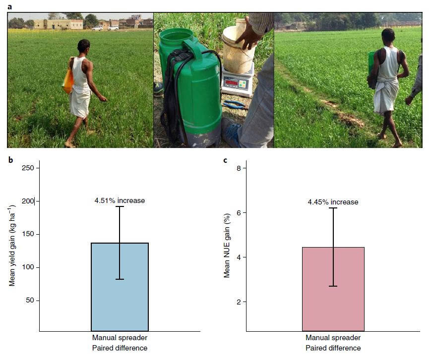
The impact of agricultural interventions can be
doubled by using satellite data
|
|
|
a, Photos showing manual broadcasting of fertilizer, the fertilizer spreader technology and the use of the technology in the field. b,c, Overall mean yield gain (b) and nitrogen use efficiency (NUE) gain (c) with confidence intervals from the spreader technology across all fields, years and treatments (P < 0.001).
|
Jain,M., Singh,B., Rao, p., Srivastava A.K., Poonia,S., Blesh,J., Azzari,G., McDonald, A.J., Lobell, D.B. Nature sustainability vol 2 October 2019
Highlights
Feeding a growing population while reducing negative environmental impacts is one of the greatest challenges of the coming decades. We show that microsatellite data can be used to detect the impact of sustainable intensification interventions at large scales and to target the fields that would benefit the most, thereby doubling yield gains. Our work reveals that satellite
data provide a scalable approach to sustainably increase food production.
|
|
|
Archetypical pathways of direct and indirect land-use change caused by Cambodia's economic land concessions
|
|
|
Map of all economic land concessions (ELCs) provided in the Open Development Cambodia (ODC) database (blue) and ELCs used in the cross-site comparison highlighted (yellow). The background data layer shows % forest cover in the year 2000.
|
Magliocca,N.R., Khuc,Q.V., Ellicott,A.V., Bremond, A.D. Ecology and Society 24(2):25
Highlights
In the global South, a rush of large-scale land acquisitions (LSLAs) is occurring by governments and transnational and domestic investors seeking to secure access to land in developing countries to produce food, biofuels, and other agricultural commodities. We conceptualize agricultural commodity production and land-acquisition processes associated with LSLAs as catalyzing causal pathways of direct and indirect land-use changes. Using the case of economic land concessions (ELCs) in Cambodia, we employed a novel synthesis research approach combining remote sensing, spatio-temporal statistics, and case study meta-analysis to construct archetypical pathways of the causes, timing, and consequences of ELC-driven land change.
|
|
|
A New Remote Sensing Approach to Enrich Hydro-power Dams' Information and Assess Their Impact Distances: A Case Study in the Mekong River Basin
|
|
|
| Spatial distribution of hydro-power dams (planned/commissioned/proposed/under construction) in the Mekong River Basin region according to the Water, Land, and Ecosystems Greater Mekong Dam database. |
|
Zihan Lin, Jiaguo Qi, Remote Sensing 2019
Highlights
Hydropower dam information such as construction and completion timings is often incomplete and missing in existing dam databases, and the hydropower dam's adjacency impact distance, which is important to the surrounding environment, is also lacking for many dams. In this study, we developed a new remote sensing approach to specifically determine the timings and to assess the influencing distance on land use and land cover at the above and below dam areas. The data determined from this study may fill important information gaps in existing dam databases, and the approach developed in this case may be generalized to the other watersheds of
the world, where hydro-power dams exist.
|
|
|
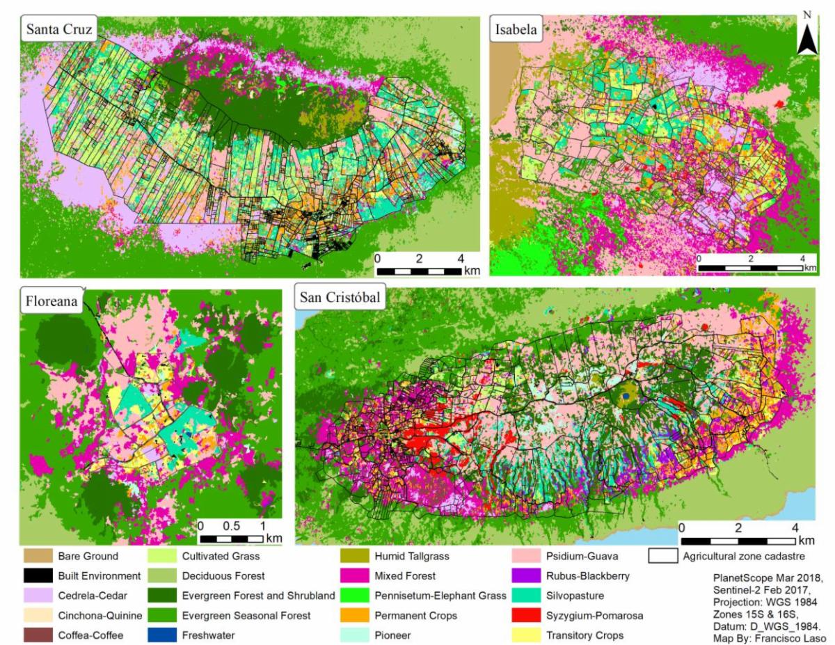
Land Cover Classification of Complex Agroecosystems in the Non-Protected Highlands of the Galapagos Islands
|
|
| Land cover classification of the agricultural areas and surrounding humid highlands of the Galapagos. |
Laso F.J., Benítez, F., Torres,G. Sampedro, C., Nazario, J. Remote Sensing, 2020 , 12(1) 65.
Highlights
The humid highlands of the Galapagos are the islands' most biologically productive regions and a key habitat for endemic animal and plant species. These areas are crucial for the region's food security and for the control of invasive plants, but little is known about the spatial distribution of its land cover. We generated a baseline high-resolution land cover map of the agricultural zones and their surrounding protected areas. We combined the high spatial resolution of Planet-Scope images with the high spectral resolution of Sentinel-2 images in an object-based classification using a Random Forest algorithm. The produced dataset is designed to suit the needs of practitioners of both conservation and agriculture and aims to foster collaboration between the two areas.
|
|
|
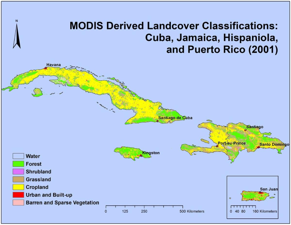
Hurricane damage detection on four
major
Caribbean islands
|
|
| Study region overview figure based on MODIS Land Cover data from 2001. |
Beurs, K., McThompson,N.S., Owsley,B.C, Henebry, G., Remote Sensing of Environment,
Volume 229
,
August 2019
, Pages 1-13
Highlights
-
Disturbance
index allows for standardization
detection of
droughts and hurricane damages.
-
Hurricanes
Maria caused significant disturbance across 50% of Puerto
Rico (4549 sq km)
-
Gradual recovery started about 2.5 months after hurricane Maria hit
|
|
|
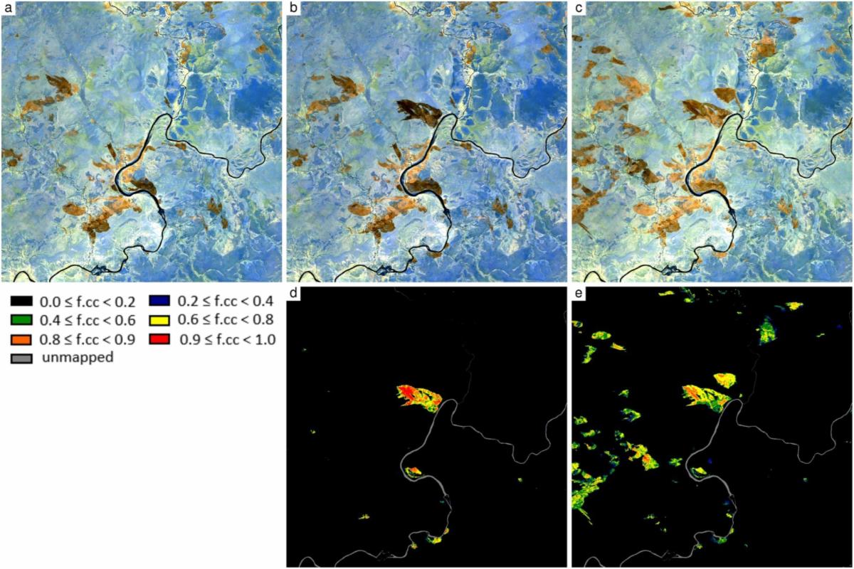
Landsat-8 and Sentinel-2 burned area mapping - A combined sensor multi-temporal change detection approach
|
|
| (a) Sentinel-2A June 2nd, (b) Landsat-8 June 3rd, (c) Sentinel-2A June 12th (all 30m surface NBAR ~2.2 μm, 1.6 μm, 0.86 μm, acquired 2016); the f.cc estimated using the RF regression applied independently at each 30m pixel location to (a) and (b) to give (d), and to (a) and (c) to give (e). Results shown for 2000×2000 30m pixels (60×60 km) in the north east corner of Kafue National park, Zambia (centered on 14.6634°S, 26.1352°E). |
Roy,D., Huang H.,Boschetti, L., Giglio, L., Yan,L., Zhang, H.H., Li, Z., Remote Sensing of Environment,
Volume 231
,
September 2019
, 111254
Highlights
- Automatic 30 m burned area mapping from Landsat-8 and Sentinel-2A time series
- Random forest change regression trained with synthetic data
- Demonstrated over the fire season for 10°x 10° of Southern Africa
- Compared with NASA MODIS burned area product and PLANET data
- Validated by comparison with Sentinel-2A interpreted burned areas
|
|
|
Senior Research Scientist Son Nghiem Named AGU Fellow
Each year since 1962, AGU has elected as Fellows members whose visionary leadership and scientific excellence have fundamentally advanced research in their respective fields. This year, 62 members will join the 2019 class of Fellows. Only 0.1% of AGU membership are selected as Fellows in any given year. This year LCLUC PI, Son Nghiem has been selected to join 2019 class of AGU Fellows.
Read More
|
|
|
Catherine Nakalembe received The GEO Individual Excellence Award
LCLUC is proud to announce that Dr. Catherine Nakalembe is one of the inaugural winners of the 2019 GEO Individual Excellence Awards
. This award is presented to individuals who have demonstrated exceptional personal commitment to the GEO Mission and whose work has had tangible impact.
|
|
|
The LCLUC Webinar Series -2019 featured LCLUC South/Southeast Asia Research Initiative (SARI) projects.
|
|
|
Recent LCLUC and Related Meetings
|
|
2019 NASA LCLUC Spring Science Team Meeting
Rockville MD 9-11 April
, 2019
This LCLUC Science Team meeting consisted of presentations from the LCLUC Science Team members funded for research on the LCLUC in Southeast Asia and Caucasus (ROSES 2016 Selections), LCLUC Synthesis projects and posters of recent results from other ongoing LCLUC research, including LCLUC-relevant projects under other NASA programs, such as Inter-Disciplinary Science and Carbon Cycle Programs, the Graduate Student Research and New Investigator Program. The third day was focused on the preliminary results from the 2017 Multi-Source Land Imaging (MuSLI) component of the LCLUC Program.
|
|
|
GOFC-GOLD Mediterranean Regional Information Network (MedRIN) meeting
Paphos, Cyprus
18 - 21 March, 2019
The second Mediterranean Regional Information Network (MedRIN) meeting and workshop took place at the Aliathon Holiday Village, in Paphos, Cyprus as a component of the 7th International Conference on Remote Sensing and Geoinformation of the Environment (RSCy2019). The conference was held 18-21 March 2019. The MedRIN workshop was held on 20 March 2019 at the conference venue.
|
|
|
Land Use/Cover Changes, Environment and Emissions in South/Southeast Asia - An International Regional Science Meeting
Johur Bahur, Malaysia
22 - 27 July, 2019
The aim of this meeting was to review the availability, potential, and limitations of different data sources and methodologies for the monitoring and the study of LCLUC, and quantification and its impact on the environment. The meeting presentations was focused on synergies among various approaches and provided recommendations on how to improve the use of earth observations, ground data and modeling techniques for the improved understanding of land use sources and sinks.
Read More
|
|
|
Global Land Programme 4th Open Science Meeting
Bern, Switzerland 24 - 26 April
, 2019
This conference represented a unique opportunity to build and enhance scientific capacity and enable transformations to a sustainable future by identifying core questions, synthesizing research, and setting future agendas. The three days were filled with engaging workshops, insightful plenaries, and many old and new inspiring connections. More than 700 participants attended the conference.
Read More
|
|
|
GOFC-GOLD South-Central East European Regional Information Network (SCERIN) meeting, Serbia, 2019
Novi Sad, Serbia 24 - 28 June, 2019
This meeting discussed current Land cover / Land use change dynamics and its impacts in SCERIN region. The SCERIN-7 capacity building workshop was focused on the current LC dynamics in the Agricultural and Protected Natural Areas in SCERIN, with the goal to identify the typical pre-cursors of land cover change (LCC) and consider our ability via remote sensing to monitor their dynamics, and estimate their influence on the local biogeochemical cycling.
Read More
|
|
|
An International Regional Science Training On "Remote Sensing of Land-Use/Cover Change and Climate Impacts In Coastal Zone"
Phuket, Thailand 17-19 December , 2019
Ninety scientists, most of which early-career researchers from South and Southeast Asia, participated in a 3-day training event on remote sensing technologies and their role in monitoring changes in land use and land cover, and quantifying climate impacts.
Hands-on training on the following themes was provided:
- Advanced Methods in Optical Remote Sensing of Land
- Land-Use/Cover Changes in Coastal Zone: Mapping and Monitoring using Remote SensingTechniques
- Mangrove Forest Assessment Using Optical Remote Sensing
- Advanced Methods in RADAR Remote Sensing
- Mangrove Forest Assessment Using RADAR Remote Sensing
- Climate Change Impacts and Coastal Erosion
- Cloud Computing using Google Earth Engine
Read More
|
|
|
Upcoming LCLUC And Related Meetings
|
|
2020 NASA LCLUC Spring Science Team Meeting
This LCLUC 2020 Science Team Meeting consists of All-Hands SARI Sessions (Presentations from Regional Programmatic Partners and P.I.'s funded as part of the SARI Program will be followed by a discussion on needs and opportunities for SARI Synthesis) and LCLUC Data Sessions (including presentations from ongoing data initiatives and P.I.'s funded under the MuSLI and VHR Projects). The meeting also includes posters of recent results from other ongoing research in LCLUC-relevant projects under other programs, such as Inter-Disciplinary Science, Carbon Cycle, Students Fellowships and New Investigator Programs
Read More
|
|
|
EARSeL Joint Workshop 2020
Liege, Belgium 26-28 May, 2020
This event is combination of
- 4th joint EARSeL LULC & NASA LCLUC Workshop
- 6th EARSeL Joint Workshop Urban Remote Sensing
- 1th EARSeL Remote Sensing For UN Sustainable Development Goals Workshop
Read More
|
|
|
First Joint SCERIN and MedRIN Workshop
Thessaloniki, Greece 15-18 June, 2020
The joint workshop will take place 15-18 June 2020 (Monday-Thursday) in Thessaloniki, Greece.
Read More
|
|
|
ForestSAT 2020
Krakow, Poland 14-18 Sept, 2020
ForestSAT 2020 will continue this long tradition of bringing together international scientists, stake holders, and policy makers from research organizations, universities, public agencies, NGOs and the private sector and marks the return of the conference to Europe.
Read More
|
|
|
|
|
|
|