|
| |
|
Marine Protected Areas
CONNECTIONS
Your news from the National Marine Protected Areas Center
|
|
|
|
|
St. Marks National Wildlife Refuge, Florida
Photo: Viktor Posner
|
|
Gallery
|
|
|
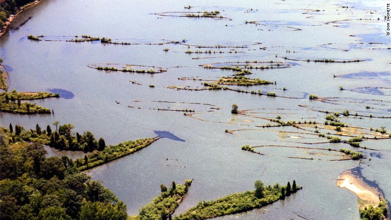
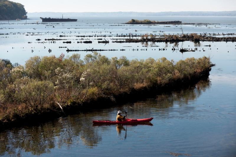
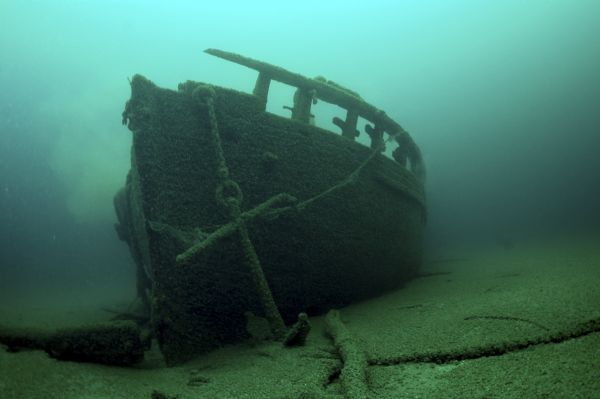
A million men built ships for the WWI Emergency Fleet effort. Mallows Bay is a graveyard for many of these vessels.
|
|
|
|
|
Mallows Bay, Maryland
Photo: Andrew Propp |
|
|
|
|
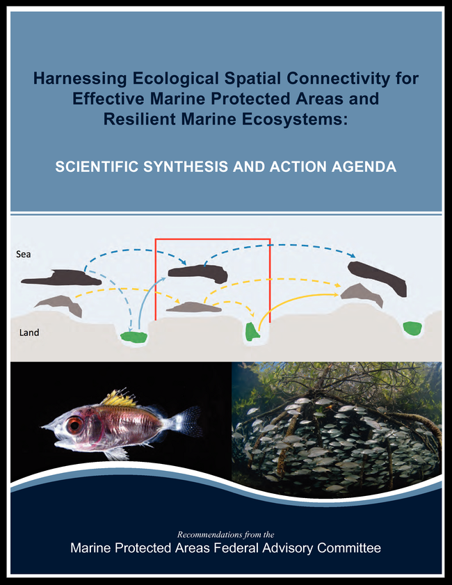
MPA FAC's newly released report on ecological connectivity
|
|
|
|
|
 |
|
NOAA moves to conserve shipwrecks in two proposed sanctuaries
|
|
|
|
The schooner "Home" is one of the oldest shipwrecks in Wisconsin
Photo: Tamara Thomsen, WHS |
|
NOAA has invited public comment through March 31 on proposals for new sanctuaries to protect historic shipwrecks in Mallows Bay, on the Potomac River in Maryland, and on Lake Michigan in Wisconsin. In Wisconsin, NOAA is proposing to designate a 1,075-square-mile area of Lake Michigan adjacent to Manitowoc, Sheboygan, and Ozaukee counties. The site would protect a nationally-significant collection of shipwrecks in the Great Lakes, including 37 known historic shipwrecks and about 80 shipwrecks thought to be in the area based on historic records. The area also includes Wisconsin's two oldest shipwrecks dating to the 1830s. In Maryland, NOAA is proposing a national marine sanctuary along a 52-square-mile stretch of the tidal Potomac River adjacent to Charles County. The site contains a collection of more than 100 known and potential shipwrecks dating from the Revolutionary War through the present. The shipwrecks include the remains of the largest "Ghost Fleet" of World War I wooden steamships built for the U.S. Emergency Fleet. Click on the links to provide comments on the Mallows Bay and Lake Michigan proposals.
|
|
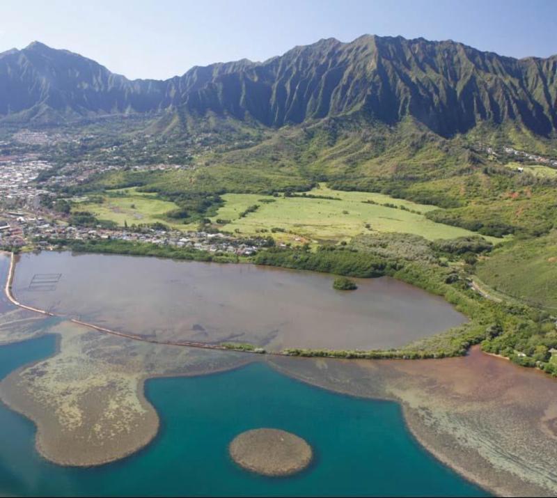
NOAA designates National Estuarine Research Reserve in Hawai'i
|
NOAA announced the designation of the He'eia National Estuarine Research Reserve
|
|
|
Photo: Manual Mejia
|
, the 29th in the system. Estuarine reserves protect a section of an estuary and provide a living laboratory to explore and understand the important areas where rivers meet the sea. The reserve will be managed in partnership with the State of Hawai'i through the University of Hawaii's Hawai'i Institute of Marine Biology (HIMB). HIMB will operate the reserve, while NOAA provides national programmatic leadership, guidance and funding. The 1,385-acre He'eia National Estuarine Research Reserve encompasses upland forests and grasslands, wetlands, reefs and seagrass beds, as well as the largest sheltered body of water in the Hawaiian Island chain. It is located within the Kāne'ohe Bay estuary on the windward side of O'ahu and includes significant historic and cultural resources. The reserve's management plan, developed with state and local partners as part of the designation process, provides direction for research, education, stewardship and cultural activities for the next five years. Management aims to integrate traditional Hawai'ian ecosystem management with contemporary approaches.
|
|
MPA Federal Advisory Committee Makes Recommendations on Ecological Connectivity for MPA Networks
|
The MPA Federal Advisory Committee, a committee of non-federal experts that advises NOAA and the Department of the Interior on MPA issues, has completed recommendations on incorporating ecological spatial connectivity into the design and management of MPAs. Connectivity refers to physical and biological processes that connect spatially discrete areas to one another in ways that are crucial to the lives of organisms, populations, ecological communities, and ecosystems. Recent research increasingly highlights the importance of ecological connectivity in the marine environment. Connectivity is also recommended as a key design element of MPA networks. Yet most U.S. MPAs were created with a focus on enhancing ecological communities within their boundaries and reducing local threats, with very few explicitly designed to consider their broader spatial context. The MPA FAC recommendations include design principles for enhancing connectivity as a component of MPA networks, using connectivity to address some climate change impacts in the marine environment, and an action agenda with recommended actions for NOAA and DOI to incorporate connectivity principles into MPA design and management, as well as connectivity guidelines for all MPA programs. A webinar on the connectivity recommendations will be held on March 9.
|
|
|
MPA Federal Advisory Committee Recommends Options for External Financing for MPA Programs
|
In addition, the
MPA Federal Advisory Committee completed a report on options for
external financing for U.S. MPA programs. Recognizing the need that MPA programs have for additional resources beyond those provided by their home institutions, the MPA FAC conducted a review of potential options of external financing sources and mechanisms for accessing external funds. The MPA FAC also made recommendations regarding future steps NOAA and DOI can take to enhance the use of external funding to support the mission of all MPA programs. Many MPA programs currently use some external funding sources, but they are generally under-utilized, and programs often face administrative barriers to accessing external funds. A
webinar on the external financing recommendations will be held on February 9.
|
|
|
Eleven new members have been appointed to the MPA Federal Advisory Committee by former NOAA Administrator Kathryn Sullivan. The Committee is made up of 20 non-governmental experts who represent a wide range of ocean interests, including fishing, tourism, conservation, state and tribal resource management, ocean energy and natural and social science. Members serve a 4-year term and advise both the Departments of Commerce (NOAA) and the Department of the Interior on issues related to marine protected areas. Committee meetings are open to the public, and provide opportunities for public comment. For a list of appointed members, click
here.
|
|
California Launches Science Program to Support MPA Network

The California Department of Wildlife (CDFW) and leading scientists at the University of California Davis, Coastal Marine Sciences Institute, will co-mentor three post-doctoral fellows to address urgent applied science needs related to MPA Network management. The program is funded by the California Ocean Protection Council using a portion of the states $2.5 million annual appropriation for the MPA Monitoring Program. The fellows and their academic and agency mentors will work on:
- creation of an MPA Monitoring Action plan which will identify the sites, temporal frequency of sampling and metrics needed to inform the adaptive management of the MPA Network in California.
- analysis and integration of an extensive remotely operated vehicle data set collected by CDFW and outside partners to gain insights on MPA performance to date and inform the creation of the MPA Monitoring Action Plan.
|
California Adopts Master Plan for Marine Protected Areas
|
California is home to the largest scientifically designed network of marine protected areas (MPAs) in the United States, resulting from the passage of the Marine Life Protection Act (MLPA) by the State's Legislature. The MLPA required the California Department of Fish and Wildlife (CDFW) to develop, and the California Fish and Game Commission (Commission) to adopt, a Master Plan to improve the design and management of California's MPAs as a statewide network. The Master Plan for MPAs, adopted by the Commission in August 2016, focuses on the shift from MPA design and planning to managing California's redesigned MPA network to meet the goals of the MLPA. To create the Master Plan for MPAs, CDFW worked in close collaboration with the Commission, California Ocean Protection Council, and California Ocean Science Trust. The Master Plan for MPAs also reflects input received from other state and federal agencies, California Tribes and Tribal governments, many other organizations and the general public.
|
NERRS Examines Marsh Resilience to Sea Level Rise
|
The National Estuarine Research Reserve System has developed a new approach to evaluate and compare the ability of tidal marshes to survive rising seas. Using data from its System-Wide Monitoring Program, the reserves successfully applied this approach at 16 sites, creating the first-ever national comparison of marsh resilience to sea level rise. While marshes in every region revealed moderate resilience to sea level rise, all exhibited at least some indication of vulnerability. The assessment used five indicators that defined the most resilient marshes as those with 1) a high marsh plain; 2) a marsh plain that is rising faster than sea level; 3) lots of sediment to help the marsh rise; 4) broad tidal range providing a buffer against the effects of sea level rise; and 5) a relatively low rate of past sea level rise. Virtually every marsh had at least one low score for one category of resilience, even though most marshes had moderate overall scores. Marshes assessed along the Pacific Coast appeared more likely to survive sea level rise than those along the Atlantic Coast. Most marshes scored high in some categories and low in others, highlighting the importance of integrating different measures to understand resilience. For example, some sites with relatively high marsh elevation -- generally considered to be a positive indicator of adaptation to sea level rise -- are sinking. These marshes were characterized as moderately resilient.
|
Expansion of the California Coastal Monument
|
|
|
|
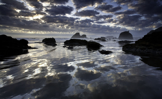
Clouds and sunset in the
California Coastal National Monument
Photo: Bob Wick, BLM |
On Jan. 12, 2017, President Obama announced the
boundary enlargement of the California Coastal National Monument with the addition of six new units that are tied to the values of the Monument to preserve important habitat for coastal plants and animals, and protect cultural sites that provide insight into the people who lived along the California coast thousands of years ago. The Monument connects the Pacific Ocean with the land and began initially in the year 2000 with a donation of 1,711 acres and was expanded again in 2004. With the new expansion it totals approximately 6,230 acres. The
new units include Trinidad Head, Waluplh-Lighthouse Ranch, Lost Coast Headlands, Cotoni-Coast Dairies, Piedras Blancas, and Orange County Rocks and Islands. The expanded Monument will continue to be managed by the Bureau of Land Management.
|
Explorer-in-Training Program Open for Applications
|
|
|
|
A mapping watchstander and marine ecologist viewing canyon data using Fledermaus software in the NOAA Ship Okeanos Explorer control room
Photo: NOAA OER |
The Okeanos Explorer-in-Training (EiT) program is open for 2017 applicants. The program has several at-sea opportunities to sail aboard the NOAA Ship Okeanos Explorer as mapping watchstanders, and to actively participate in cruises from shore at the University of New Hampshire's Center for Coastal and Ocean Mapping. This marks the third year of the Campaign to Address Pacific monument Science Technology and Ocean Needs (CAPSTONE), focused on deepwater areas of U.S. marine protected areas in the central and western Pacific. NOAA conducts telepresence-enabled mapping and remotely operated vehicle (ROV) operations in poorly known ocean areas with Okeanos Explorer to support deepwater habitat characterization and spur follow-on efforts. For participation in a program from June to Sept. 2017, applications are due Feb. 17th. You can find more information here. For questions contact:
|
Webinars from the MPA Center and Partners
|
The MPA Center monthly webinar series is co-sponsored by MPA News, and the EBM Tools Network (co-coordinated by NatureServe and OpenChannels.org)
and held the second Thursday of each month from 1:00 to 2:00 p.m. Eastern. The series is focused on building and strengthening MPA networks.
Feb. 9
By Brian E. Baird, MPA Federal Advisory Committee External Financing Subcommittee Chair and Director,
Ocean & Coastal Program, The Bay Institute and Aquarium of the Bay
Dr. Martha Honey, MPA Federal Advisory Committee External Financing Subcommittee Vice-Chair, and Co-Founder and Executive Director, Center for Responsible Travel (CREST)
MPAs require sustainable long-term funding for designation and management, specifically education, outreach, monitoring, research, policy development, and enforcement. Recommendations from a new report produced by the Marine Protected Areas Federal Advisory Committee will be discussed, along with a wide-range of approaches to obtain external funding, important guidelines for success, and potential sources of external financing.
Mar. 9
By Mark Carr, Professor, Department of Ecology and Evolutionary Biology, Long Marine Laboratory, University of California, Santa Cruz
Dr. Sarah Robinson, Critical Inquiries Research, Brookline, Massachusetts
The US Marine Protected Area (MPA) Federal Advisory Committee (FAC) has a Connectivity Subcommittee charged with understanding how knowledge about ecological spatial connectivity and climate climate change can be incorporated into the design, use, and management of effective MPAs and MPA networks. The committee has summarized the current scientific understanding of:
1) different types and scales of connectivity and their ecological implications, 2) how connectivity processes create ecological linkages among marine areas, populations, communities, and ecosystems, and 3) how connectivity impacts conservation outcomes in MPAs. This webinar will summarize the work of the FAC on the
implications of spatial ecological connectivity for the design and application of MPAs in a changing ocean. This work forms the basis of the FAC's recommendations to the US Secretaries of Commerce and the Interior for future US MPA management and policy.
Apr. 13
By Carlie Herring, Research Coordinator, Marine Debris Program, NOAA Office of Response and Restoration
A presentation on microplastics; what they are, the different types, the impacts associated with microplastic marine debris, and future research needs.
He'eia National Estuarine Research Reserve
By Matthew Chasse, Coastal Management Specialist, NOAA Office for Coastal Management
June 8
A Coastal Conservation Leadership Program in Washington State
By Casey Dennehy, Surfrider Foundation, Washington Coast Program Manager
|
|
|
|
| |
|