Hurricane Ida is making its way toward the Gulf of Mexico, moving northwest from the Caribbean at 15 mph. The storm is expected to enter the Gulf late today or early tomorrow and strengthen into a major hurricane as energy from warm Gulf waters provide fuel for intensification. It's expected to be in the northern Gulf on Sunday.
GCOOS encourages you to be proactive in your hurricane preparations and we offer a resource page to help you track the storm, find local evacuation and shelter information, learn about the science of hurricanes, and more.
After the storm, GCOOS will also be tracking damage to the ocean observing infrastructure in the Gulf. Please bookmark this survey to use after the storm, should any of your assets, platforms or data infrastructure incur damage. (Don't worry — we'll send the link around again!)
|
|
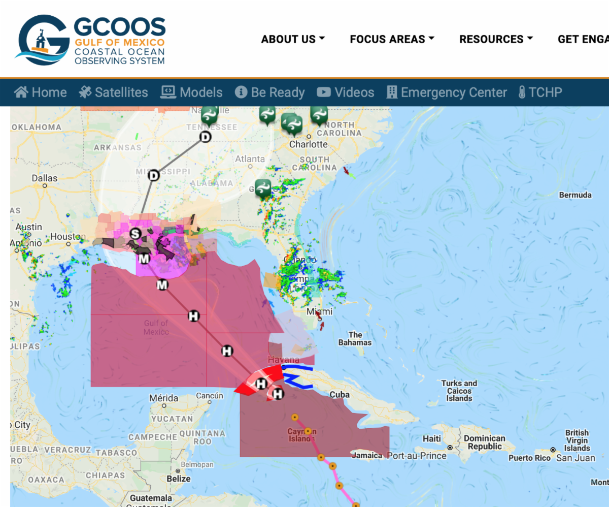
Watches and Warnings at a Glance |
|
As the storm approaches landfall in coastal Louisiana and Mississippi, it's important to understand information provided by NOAA's National Hurricane Center.
Hurricane Watches and Warnings: Under a hurricane watch, hurricane conditions (sustained winds of 74 mph or greater) are possible within your area. Because it may not be safe to prepare for a hurricane once winds reach tropical storm force, the National Hurricane Center (NHC) issues hurricane watches 48 hours before it anticipates tropical storm-force winds.
Under a hurricane warning, hurricane conditions are expected somewhere within the specified area. The NHC issues a hurricane warning 36 hours in advance of tropical storm-force winds to give you time to complete your preparations. All preparations should be complete. Evacuate immediately if so ordered.
- Completing preparations early is especially important for storms like Ida that are forecast to intensify rapidly and become major hurricanes. Procrastinating about preparing can have dire consequences so please heed these notifications!
Storm Surge Watches and Warnings: Like hurricane watches and warnings, storm surge watches and warnings are issued to give people advanced notice that conditions over the next couple of days will deteriorate rapidly.
A storm surge watch is issued when there is the possibility that your area will experience life-threatening flooding or become isolated when a storm pushes water from the shoreline inland. Storm surge watches are usually issued within 48 hours of expected impacts but can be issued earlier depending on how much time officials anticipate people need to take protective actions like evacuating.
A storm surge warning means that dangerous conditions are expected within 36 hours. Like storm surge watches, the designation to warning may be issued sooner if officials think more preparation time is needed.
|
|
If you're looking for a unique view of some of the data that go into the hurricane forecast models, check out
Developed by GCOOS Systems Architect and Co-Data Manager, Felimon Gayanilo, the portal serves information from the Gulf’s deepest mooring — Shell’s Alcyone Buoy.
This amazing technological achievement sits in about 3,000 meters of water on Walker Ridge in the Outer Continental Shelf. Equipped with sensors that measure water and air temperature, wave height, dominant wave period, barometric pressure, and even ocean currents down to 1,000 meters (about 3,280 feet), it provides a unique opportunity to track conditions before, during and after Ida’s passage through the Gulf.
GCOOS also tracks glider deployments in the Gulf. If you're looking for near real-time data from gliders already deployed in advance of the storm, visit our data server:
|
|
Watch Now
The New Normal: Hurricanes
|
|
GCOOS is the Gulf of Mexico regional component of the U.S. Integrated Ocean Observing System (IOOS) and the only certified system dedicated solely to the Gulf of Mexico. Our mission is to provide timely, reliable and accurate information on the open ocean and coastal ocean waters of the Gulf of Mexico to ensure a healthy, clean, productive ocean and resilient coastal zone. |
|
Dr. Jorge Brenner, Executive Director • Dr. Barbara Kirkpatrick, Senior Advisor • Bill Lingsch, U.S. Glider User Group Coordinator • Dr. Chris Simoniello, Outreach & Education Coordinator • Felimon Gayanilo, DMAC Co-Manager & Systems Architect • Dr. Shinichi Kobara, Assistant Research Scientist, Product Developer • Bob Currier, DMAC Co-Manager, Research Specialist & Product Developer • Marion Stoessel, Senior Research Associate • Jennifer Vreeland-Dawson, Research Associate • Grant Craig, Program Coordinator • Nadine Slimak, Public Relations & Content Marketing, Vetted Communications, LLC • Dr. Chuan-Yuan Hsu, Post-Doctoral Research Associate • Laura Caldwell, Program Assistant
|
|
In Memoriam: Matt Howard, 1952-2018
|
|
|
|
|
|
|