Dear Florida Climate Center friends,
We'd like to present you with the Early Summer 2018 edition of our newsletter. In this newsletter, you'll find our April, May, and June 2018 monthly climate summaries and an update on the wealth of activities in which we've recently been engaged. If you have any questions, please send us an e-mail message at climate@coaps.fsu.edu.
Thanks,
The Staff of the Florida Climate Center
 |
 |
David Zierden
State Climatologist |
Danny Brouillette
Service Climatologist |
|
April, May, and June Climate Summaries for Florida
The Florida Climate Center's
April 2018 Florida Climate Summary and
May 2018 Florida Climate Summary are now available. The monthly summary provides an analysis of temperature and precipitation patterns during the past month across the state, along with data on hazardous weather, drought, the impacts of the weather, and any records tied or broken for the month. During April, temperatures were slightly warmer than average, registering 70.0 degrees Fahrenheit, the 44th highest on record since 1895.
The statewide-averaged rainfall total was above the historical median, coming in at 3.60", making for the 43rd-driest April on record. May was the 36th warmest on record, with a statewide mean temperature of 76.1 degrees Fahrenheit. The month was also record-wet, with a statewide average total of 9.23". June data remain unofficial, but it was a month with above-normal temperatures at most locations and spatially variable rainfall; more can be found in our monthly climate
summary. ENSO-neutral conditions are now in place, with a continued uncertain outlook for the upcoming fall and winter. Going into July, the
NOAA Climate Prediction Center outlooks Florida for an enhanced probability of above-normal temperatures and equal chances of above-, near-, and below-normal rainfall.
The following table gives April average temperatures and departures from normal (˚F) for selected cities.
| Station |
Average Temperature |
Departure from Normal |
| Pensacola |
66.3 |
-0.3 |
| Tallahassee |
66.1 |
0.0 |
| Jacksonville |
67.3 |
+0.3 |
| Gainesville |
69.4 |
+1.8 |
| Orlando |
73.1 |
+1.9 |
| Tampa |
74.6 |
+2.6 |
| West Palm Beach |
74.6 |
+0.8 |
| Miami |
77.1 |
+1.3 |
| Key West |
78.1 |
+1.7 |
The following table gives April precipitation totals and departures from normal (inches) for selected cities.
| Station |
Total Rainfall
|
Departure from Normal |
| Pensacola |
3.99 |
-0.33 |
| Tallahassee |
3.72 |
+0.66 |
| Jacksonville |
5.23 |
+2.59 |
| Gainesville |
7.49 |
+4.82 |
| Orlando |
2.14 |
-0.54 |
| Tampa |
2.16 |
-0.13 |
| West Palm Beach |
7.31 |
+3.65 |
| Miami |
3.80 |
+0.66 |
| Key West |
0.21
|
-1.84 |
The following table gives May average temperatures and departures from normal (˚F) for selected cities.
| Station |
Average Temperature |
Departure from Normal |
| Pensacola |
78.4 |
+3.8 |
| Tallahassee |
76.9 |
+2.6 |
| Jacksonville |
75.1 |
+1.3 |
| Gainesville |
75.9 |
+1.2 |
| Orlando |
76.9 |
-0.4 |
| Tampa |
79.0 |
+0.6 |
| West Palm Beach |
77.4 |
-1.0 |
| Miami |
78.4 |
-1.5 |
| Key West |
78.9 |
-1.4 |
The following table gives May precipitation totals and departures from normal (inches) for selected cities.
| Station |
Total Rainfall |
Departure from Normal |
| Pensacola |
3.73 |
-0.45 |
| Tallahassee |
6.97 |
+3.50 |
| Jacksonville |
5.91 |
+3.43 |
| Gainesville |
8.38 |
+5.90 |
| Orlando |
7.49 |
+4.04 |
| Tampa |
7.73 |
+5.63 |
| West Palm Beach |
11.41 |
+6.90 |
| Miami |
16.59 |
+11.25 |
| Key West |
14.17 |
+11.17 |
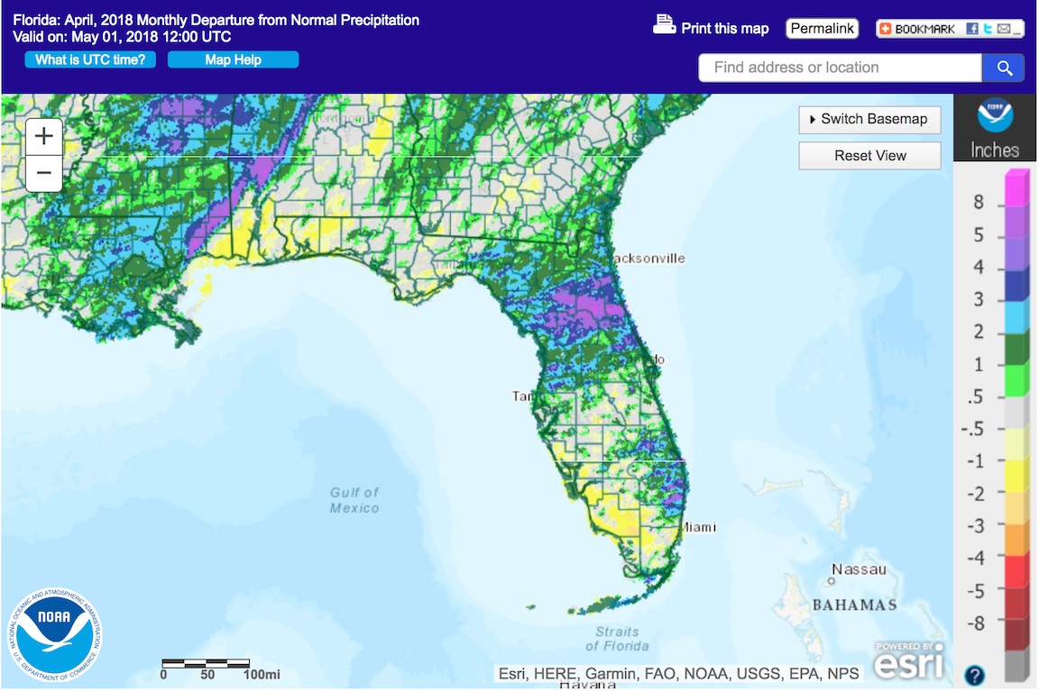
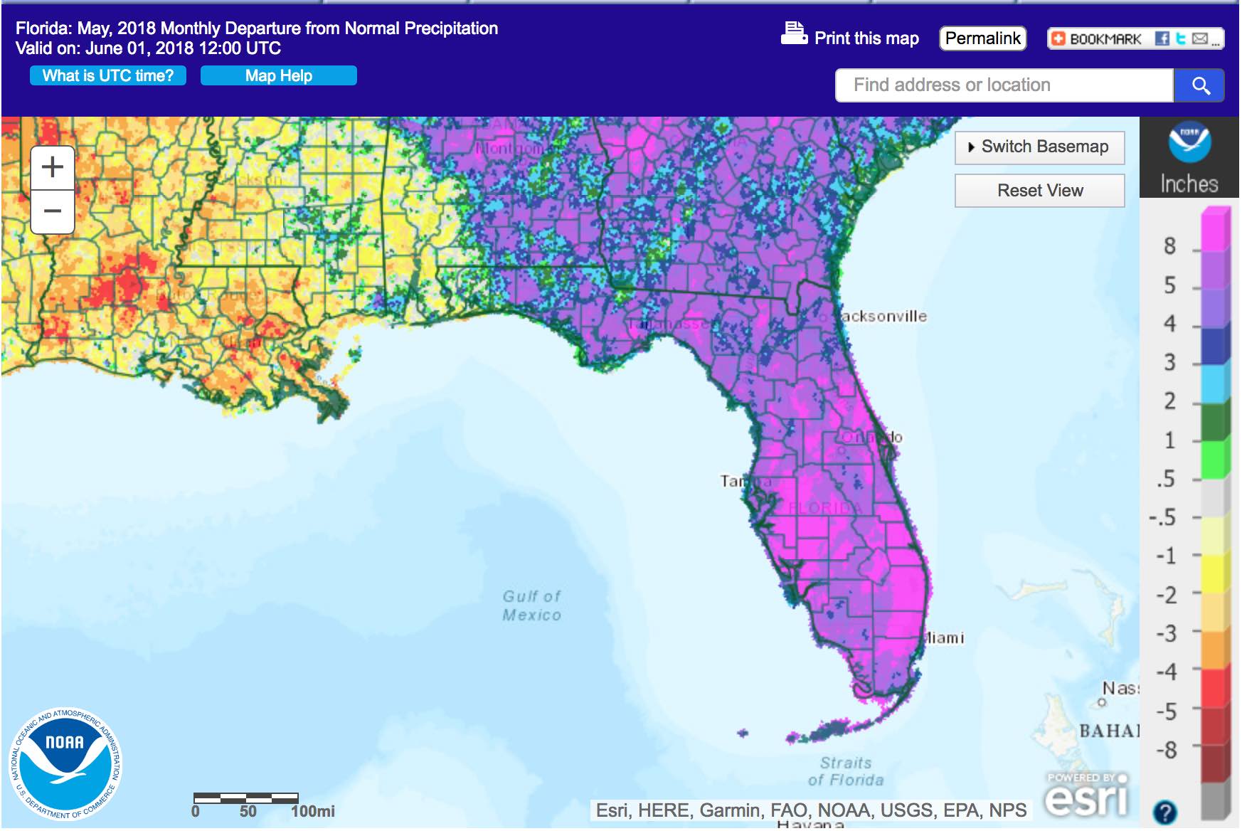
The following schematics map April and May precipitation departures from normal, respectively, across Florida. Images courtesy of the National Weather Service.
|
|
Service Climatologist Presents to Children at Leon County Public Library
On 13 June, Danny Brouillette, Service Climatologist with the Center, presented to a group of school-age children at the Dr. B.L. Perry, Jr., branch of the Leon County Public Library in Tallahassee. His presentation, entitled "All About Climate and Climatologists" was part of that branch library's "Brainshops" series, which is a series of free summer-time science workshops presented by topical experts from the Tallahassee area.
|
|
Near- to Below-Normal Atlantic Hurricane Season Now Expected
As of the first week of July, only one named cyclone has formed, which was Alberto in late May. Consequently, June 2018 was the first June since 2014 to have no named cyclones. Conditions during the month were generally unfavorable for the formation of tropical cyclones. These conditions included historically below-normal sea-surface temperatures in the tropical Atlantic Ocean (below image), dust from the Sahara Desert in Africa over the same region, and warming waters in the equatorial Pacific Ocean as that region shifts from weak La Nina (ENSO-negative) conditions to ENSO-neutral conditions.
These unfavorable conditions are increasingly expected to continue through the balance of the hurricane season, which has led some forecasting groups, notably including the one at the Colorado State University, to issue updated outlooks that call for a near- to below-normal number of tropical-cyclone formations in the 2018 season.
|
|
Teaming up with New York State to Study Heat Vulnerability
State Climatologist David Zierden and FSU Geography graduate student Jihoon Jung attended the annual meeting for the NASA ROSES project on heat vulnerability on 3-5 June in Albany, New York. The project uses high-resolution satellite measurements of surface temperature to better identify where local heat maxima can intersect with vulnerable populations. Partners in the project include New York State Department of Health, New York City Health Department, the New York Health Research Institute, University of Alabama Huntsville, Florida Department of Health, and Florida State University. The project is in the final year of a three-year grant and has made great progress validating the satellite measurements and performing case-crossover analysis with heat related health outcomes.
|
|
Florida Climate Center in the News
|
| About Us The Florida Climate Center is part of a three-tiered system of national, regional, and state climate offices, including NOAA's National Centers for Environmental Information (NCEI - in Asheville, North Carolina) and the Southeast Regional Climate Center (in Chapel Hill, North Carolina). The Florida State Climatologist and other staff at the Florida Climate Center provide the following information and services to the people of Florida:
· Climate Data: Historical weather observations for weather stations throughout the state of Florida. We are able to provide data for most stations from 1948-present.
· Climate Information: Long-term historical averages for various stations, climate divisions, and the entire state.
· Extreme Event Records: Information and analyses on extreme events such as freezes, droughts, floods and hurricanes.
· Special Analysis: With their vast knowledge of El Niño, La Niña and climate variability, the State Climatologist and staff can offer expert insight into Florida's climate trends.
· Outreach: Activities, presentations, and workshops that inform and educate the people of Florida about current and emerging climate issues. We also coordinate volunteers for the Community Collaborative Rain, Hail & Snow Network (CoCoRaHS).
More About Us |
|


