Water Supply Program
Quarry/Chattahoochee/Hemphill
|
|
Update
:
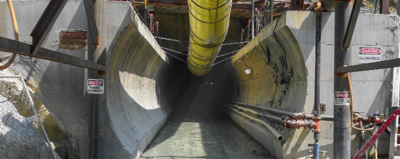
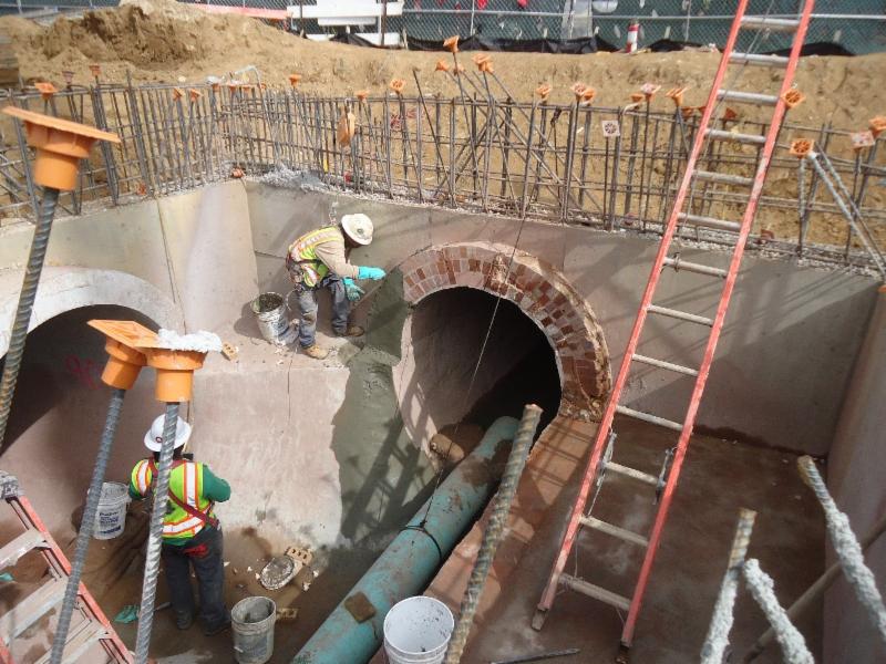
Crews are cleaning and lining the interior of the tunnel with concrete liner. Approximately 1,400 feet of the lining is complete.
Controlled blasting at the R.M. Clayton Water Reclamation Center has resumed, and the construction of the Quarry and Hemphill pump station continues.
The Water Supply Program will increase Atlanta’s reserve water supply from three to five days to 30 to 90 days. The $300 million investment includes the construction of a five-mile tunnel connecting the Chattahoochee River, the Hemphill Water Treatment Plant and the former Bellwood Quarry which will be transformed into a 2.4 billion-gallon reservoir. The Water Supply Program is scheduled for completion by September 2019.
Expected Completion:
September 2019
Project Location:
Northwest Atlanta
Council District(s):
3, 9
Neighborhood Planning Unit(s):
C, D, G, J, K
|
|
Hartsfield-Jackson Manifold Improvements Project
|
|
Update:
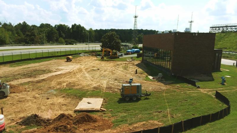
Work continues at the pump station on South Loop Road at Hartsfield-Jackson Atlanta International Airport. Contractors will be preparing slab area for geopier installation and clearing of detention pond. Once geopier installation is completed, contractors will start form work, rebar and concrete placement at the slab. Contractors will also install a storm pipe at the detention pond.
This project reinforces the integrity of services for which the Hartsfield-Jackson Water Distribution Facility was constructed. This will ensure availability of uninterrupted quantity and quality of water distribution to the airport.
Expected Completion:
June 2019
Project Location:
South Loop Road, Hartsfield-Jackson Atlanta International Airport
Council Districts:
11, 12
Neighborhood Planning Units:
P, Q, R, Z
|
|
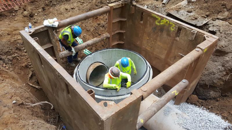
Clear Creek West Sewer Improvements Project
Civic Center Vault
|
|
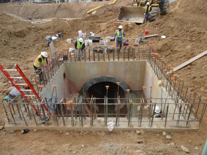
Update:
Crews continue to pour the walls and foundation of the vault. In addition, crews will tie- in rebar and pour columns and slabs.
The City of Atlanta Department of Watershed Management has identified the need for an underground storage vault to be installed to increase the storage capacity of the existing combined sewer system in the Clear Creek West basin. The vault associated with this project is located in the southeastern corner of the existing Civic Center parking lot adjacent to Ralph McGill Boulevard. The Butler Street trunk and relief combined sewers drain the upper section of the west Clear Creek basin. During certain rainfall events this system can become surcharged, which may result in flooding. The storage vault will store excess combined sewer flows from the Butler Street Relief Combined Sewer, which intercepts at the I-75/85 entrance ramp from Freedom Parkway and Highland Avenue. Stored combined sewer flow in the vault will reduce the peak flow in the downstream combined sewer helping to reduce flooding.
This stormwater vault will help manage rainfall runoff from the adjacent federal highways and downtown portions of the basin. Additionally, implementation of green infrastructure projects is proposed to further manage combined sewer peak flows to the combined sewer system and to reduce the required capacities of the vaults.
Expected Completion:
March 2019
Project Location:
Northeast Atlanta
Council District(s):
2
Neighborhood Planning Unit(s):
M, E
|
|
Upper Proctor Creek Capacity Relief Project
Rodney Cook Sr. Park In Historic Vine City
|
|
Update:
The Upper Proctor Creek Capacity Relief project: Rodney Cook, Sr. Park in Historic Vine City is a multi-phase effort to reduce flooding and combined sewer flows in the Vine City neighborhood.
This project consists of a collection of innovative stormwater practices designed to redirect surface runoff away from the Beckwith Trunk and Mineral Springs combined sewer systems.
The capacity relief facility is currently under construction led by the Astra/Rohadfox, Joint Venture.
The components of this project include a 2-acre pond (9+ MG capacity), green infrastructure (bioretention, stormwater planters, rainwater harvesting cisterns, and soil restoration), aerating water features, separated storm drain pipelines, new sidewalks and roadway improvements.
The Department of Watershed Management is working concurrently with The Trust for Public Land who is responsible for the build out of the adjacent park. In addition, The National Monuments Foundation will be constructing statues of historic figures throughout the finished park.
Expected Completion:
April 2019
Project Location:
Vine Street NW
Council District(s):
3
Neighborhood Planning Unit(s):
L
|
|
Upper Proctor Creek - Boone Boulevard Green Infrastructure & Capacity Relief Project
|
|
Update
:
Due to the moratorium imposed on the City Of Atlanta for Super Bowl LIII , work on Boone Boulevard will be temporarily suspended from January 21, 2019 until February 11, 2019. In preparation for Super Bowl LIII, contractors will be installing pedestrian fencing alongside parts of Joseph E. Boone Boulevard NW, between Elm Street NW and Maple Street NW. Contractor will monitor traffic control and pedestrian fencing on Joseph E. Boone Boulevard NW during moratorium. After February 11, 2019, contractors will continue work on installation of planter boxes and replacing of water main on Joseph E. Boone Boulevard NW.
This project will provide capacity relief to the North Avenue Combined Sewer Area and water quality improvements using the green infrastructure practice called bioretention, which is a specially landscaped area that captures runoff from an impervious surface and allows water to enter the soil. Proposed bioretention areas will span approximately 1.2 miles along Boone Blvd from Mayson Turner Road to Northside Drive that will collect stormwater runoff from along the sides of the road.
Expected Completion:
June 2019
Project Location:
Northwest Atlanta
Council District(s):
3
Neighborhood Planning Unit(s):
L
|
|
Energy Services Performance Initiatives -
Noresco
|
|
Update:
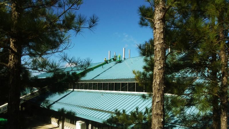
Crews continue working on foundation for Blower Building installing geopiers at RM Clayton. Upon completion of geopiers, crews will start pouring the concrete slab. Five pressure sensors have been installed with seven remaining. Contractor will also start work on new UV System.
Three Energy Conservation Measures (ECM) for a software system to optimize the City's water distribution system is being implemented: A new Class A bio-solids system, office space at RMC WRC, and a replacement of ultraviolet disinfection system with new Trojan UV Signa System.
Expected Completion:
December 2020
Project Location:
RM Clayton WRC
Council District(s):
2, 3, 4, 5, 6, 7, 8, 9
Neighborhood Planning Unit(s):
C, D, G
|
|
Energy Services Performance Initiatives -
Schneider
|
|
Update
: Contractors continue the work of removing the old dome off digester #5 and continue to clean out digester #4 at South River WRC. Lighting upgrades are 95percent complete at our 14th Street Administration Complex. Roof work is in the final stages of completion at Utoy Creek.
Facilities infrastructure improvements are underway for RM Clayton WRC, Hemphill water distribution system, South River WRC, Utoy Creek WRC, Chattahoochee Water Treatment and 14th Street Administration Complex.
Expected Completion
: December 2020
Project Location
: RM Clayton WRC, Hemphill WTP (Settled Solids only), South River WRC, Utoy Creek WRC, Chattahoochee Water Treatment, and 14th St Admin Complex
Council District(s)
: 1, 3, 8, 9, 10
Neighborhood Planning Unit(s)
: C, D, E, G, H, Z
|
|
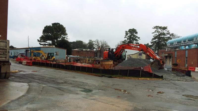
RM Clayton Nutrient Recovery System – Ostara
|
|
Update
: Contractors continue working on foundation for the Nutrient Recovery Building with 85 percent completion of outside foundation and 88 percent completion of installation of micro-piles.
The purpose of this project is to improve nutrient (phosphorus and nitrogen) removal within the RM Clayton WRC. Enhanced nutrient removal will improve permit compliance, reduce chemical and operating costs, and provide a reusable byproduct.
Expected Completion:
September 2019
Project Location:
RM Clayton WRC
Council District(s):
2, 3, 4, 5, 6, 7, 8, 9
Neighborhood Planning Unit(s):
C, D, G
|
|
Clear Creek Combined Sewage Control Facility
|
|
Update:
Clear Creek Combined Sewage Control Facility (CSCF), one of the combined sewer control systems owned and operated by the City, is located in the West Service Area of the City of Atlanta. During large storm events, when the capacity of the tunnels and the West Area WQCF are exceeded, the combined flows enter the Clear Creek CSCF and the combined wastewater is treated through coarse bar screening and fine drum screening, disinfected with sodium hypochlorite (NaOCl) and dechlorinated with sodium bisulfite.
Upgrades to the NaOCI storage tanks, pump and piping system will improve system reliability.
Various improvements to other water quality control facilities (WQCF) are included in the project.
Expected Completion:
January 2019
Project Location(s):
Nancy Creek, Peachtree Creek, Proctor Creek, Sugar Creek, Cluster Basin
Council District(s):
2, 3, 5, 6, 7, 8, 9
Neighborhood Planning Unit(s):
A, B, D, E, F, G, H, K, M, O
|
|
R.M. Clayton Water Reclamation Center (WRC) Instrumentation/Controls Reliability Restoration
|
|
Update:
Construction phase is underway.
The R.M. Clayton Water Reclamation Center Instrumentation/Controls Reliability Restoration project will upgrade various outdated Distributive Control Systems (DCS) and Process Logic Controller (PLC) systems as well as add optical fibers and duct banks at the RM Clayton WRC. These systems monitor and control various process equipment and provide the interconnectivity required to treat wastewater to meet regulatory compliance permits.
Expected Completion
: TBD
Project Location
: Northwest Atlanta
Council District(s)
: 9
Neighborhood Planning Unit(s)
: C, D, G
|
|
Proctor Creek Sewer Basin
Ashby-Jett Sewer Improvement Project
|
|
Update:
The Ashby-Jett Sewer Improvement Project broadened scope also includes upgrades to the existing 36-inch diameter Greensferry Trunk Sewer Realignment.
The scope of work will consist of the realignment and upsizing of the existing 36-inch to a 42 and 48-inch diameter sewer. The project site abuts Maddox Park from the east and Pierce Avenue from the west, and Donald Lee Hollowell Parkway from the north. The project encompasses several parcels that were formerly residential and prone to flooding and were acquired by the City. A new park and stormwater pond are planned to remedy localized flooding within the location.
Expected Completion:
March 2019
Project Location(s):
Bankhead, Hills Park, Center Hill, Grove Park, Washington Park, Hunter Hills Knight Park
Council District(s):
3
Neighborhood Planning Unit(s):
L, K
|
|
Oldfield Outfall Sewer Improvements &
Howell Mill Road Outfall Sewer Improvements
|
|
Update
: The Oldfield Outfall Sewer work, starting in 1st Quarter 2019, will eliminate repeat sewer overflows, remedy surcharging and provide additional capacity in the existing sewer network. The project involves the realignment and construction of roughly 2,200 linear feet of both 8-inch diameter and 24-inch diameter gravity sewers. Construction methodology will consist of open-cut replacement and trenchless methods, demolition of the existing aerial sewer, as well as manhole rehabilitation.
The Howell Mill Road Outfall Sewer Improvements involves the realignment of the existing 8-inch aerial sanitary sewer. Starting in 1st Quarter 2019, roughly 1,500 linear feet 4-inch diameter force-main transitioning to an 8-inch diameter gravity sewer and a new duplex pump station will be constructed. Located in the Peachtree Creek Sewer Basin, the Outfall convey sewage from the Peachtree Battle community to the 90-inch diameter Peachtree Creek Trunk sewer that also traverses through the footprint of Atlanta Memorial Park.
Expected Completion
: 2019
Project Location
: Atlanta, GA
Council District(s)
: 8
Neighborhood Planning Unit(s)
: C
|
|
Neighborhood Planning Unit (NPU)
The City of Atlanta is divided into 25 Neighborhood Planning Units (NPU), which serve as citizen advisory councils that make recommendations to the Mayor and City Council on zoning, land use, and other planning issues. NPUs also allow citizens to receive information about all functions of city government.
|
|
See neighborhoods located within listed NPUs below:
|
|
NPU-B
- Brookhaven
- Buckhead Forest
- Buckhead Village
- East Chastain Park
- Garden Hills
- Lenox
- Lindbergh/Morosgo
- North Buckhead
- Peachtree Heights East and West
- Peachtree Hills
- Peachtree Park
- Pine Hills
- Ridgedale Park
- South Tuxedo Park
NPU-C
- Arden/Habersham
- Argonne Forest
- Brandon
- Castewood
- Channing Valley
- Collier Hills
- Collier Hills North
- Colonial Homes
- Cross Creek
- Fernleaf
- Hanover West
- Memorial Park
- Peachtree Battle Alliance
- Ridgewood Heights
- Springlake
- Wesley Battlle
- Westminister/Milar
- Westover Plantation
- Wildwood
- Woodfield
- Wyngate
NPU-D
- Berkley Park
- Blandtown
- Bolton
- Hills Park
- Riverside
- Underwood Hills
- Whittier Mill Village
NPU-G
- Almond Park
- Atlanta Industrial Park
- Bolton Hills
- Brookview Heights
- Carey Park
- Carver Hills
- Chattahoochee
- English Park
- Lincoln Homes
- Monroe Heights
- Rockdale
- Scotts Crossing
- West Highlands
NPU-J
- Center Hill
- Dixie Hills
- Grove Park
- Harvel Homes
- Penelope Neighbors
- West Lake
|
|
NPU-K
- Bankhead
- Hunter Hills
- Knight Park/Howell Station
- Mozley Park
- Washington Park
NPU-L
NPU-M
- Castleberry Hill
- Downtown
- Old Fourth Ward
NPU-O
- East Lake
- Edgewood
- Kirkwood
- The Villages at East Lake
NPU-P
- Arlington Estates
- Ashley Courts
- Ben Hill
- Brentwood
- Briar Glen
- Butner/Tell
- Cascade Green
- Deerwood
- Fairburn
- Greenbriar Village
- Heritage Valley
- Huntington
- Kings Forest
- Lake Estates
- Meadowbrook Forest
- Mellwood
- Mt. Gilead Woods
- Niskey Cove
- Niskey Lake
- Princeton Lakes
- Wildwood Forest
NPU-S
- Bush Mountain
- Cascade Avenue/Road
- Fort McPherson
- Oakland City
- Venetian Hills
- Westmont Estates
NPU-T
- Ashview Heights
- Atlanta University Center
- Harris Chiles
- Just Us
- The Villages at Castleberry Hill
- West End
- Westview
|
|
Department of Watershed Management
72 Marietta Street NW
Atlanta, GA 30303
|
|
|
|
|
|
|