|
A Message From the Core Committee
Greetings Volunteers and Friends:
As the United States just celebrated the Thanksgiving holiday and people around the globe prepare for the end-of-year festivities, we reflect on all we have to be thankful for.
The nine members of GISCorps Core Committee and Advisory Board are thankful for the
5,000+ volunteers
who continue to share their GIS skills and expertise with organizations and communities in need worldwide, whether through formal GISCorps missions or by taking the GIS Service Pledge to support an organization close to home. GISCorps volunteers have contributed over 70,000 hours of service since URISA's GISCorps was launched in 2003!
We are also thankful for
our partners
, who trust us with these exciting opportunities to serve, learn, and share our love for all things geospatial. And finally, we are grateful to
our supporters
, who believe in our mission and enable us to continue to pursue it with
donations
big and small. This includes the many 2019 GIS-Pro conference attendees who placed bids at a silent auction, raising nearly $3,000 for GISCorps! Thank you!
Speaking of the nine members of the GISCorps Core Committee and Advisory Board,
we're still looking for additional experienced volunteers to join our Core Committee and manage GISCorps missions. If you're interested in taking on this role, let us know by sending an email to: [email protected]
With warmest regards and deepest gratitude,
GISCorps Core Committee and Advisory Board: Shoreh Elhami, Dianne Haley, Konrad Hughes, Allen Ibaugh, Carol Kraemer, Wincy Poon, German Whitley, Troy Wirth, and Chris Zumwalt.
P.S. Please email
[email protected]
if you wish to be removed from this list.
|
| Deployment and Partnership News |
Completed Missions
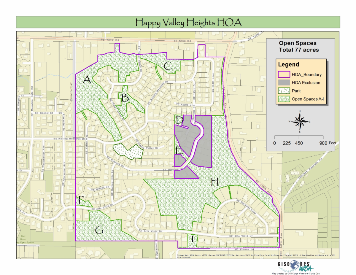
Volunteer Mapping Green Space in an Oregon Neighborhood
The
Happy Valley Heights Homeowners Association
requested help from GISCorps to map the open spaces containing older second-growth forests and wetlands in their neighborhood. Volunteer Curtis Day accepted this task, creating a cartographic product for both the website and for use in Avenza for on-site maintenance
Read more about this project here.
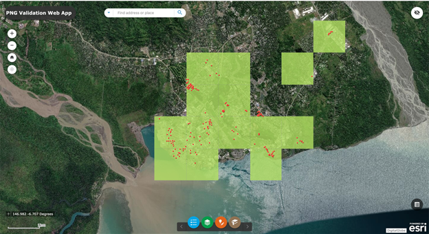
Validation of Building Sites in Papua New Guinea
Five GISCorps volunteers (Linder Ringo, Bhanu Vedula, Melissa Daniels, Amy Murphy, and Lance Owen) stepped up to help the
World Health Organization
with a pilot project combining crowdsourcing with artificial intelligence to support polio outbreak response activities in Papua New Guinea. In the first phase of this innovative pilot project, the volunteers validated building location data to create a sample set to feed an artificial intelligence engine to enable it to extract more building points. In the eventual second phase, the group will validate the AI engine's output.
Read more about this project here.
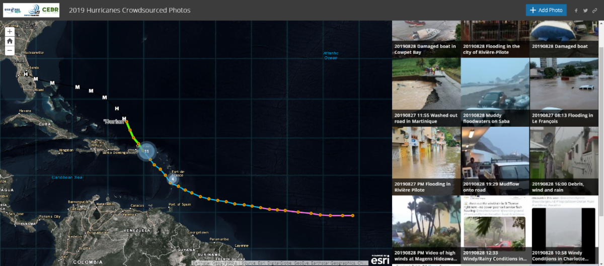
GISCorps Volunteers Map Hurricane Dorian Preparedness and Damage
In an ongoing partnership with the
National Alliance for Public Safety GIS (NAPSG)
and
CEDR Digital Corps
, GISCorps provided 28 volunteers to scour social media and news outlets for photos depicting on-the-ground conditions before, during, and after Hurricane Dorian. The volunteers then geolocated and mapped each photo on
an interactive web map
designed to provide situational awareness for emergency managers and first responders throughout the affected region, which stretched from the Windward Islands of the Caribbean to the Maritime Provinces of Canada. The six-member
2019 Hurricanes Admin Team
vetted each photo, assigning FEMA community lifelines and verifying locational accuracy.
Read more about this project
here
.
New Missions in Progress
GISCorps volunteer Bhanu Vedula is assisting nonprofit
One Shared Story
with implementing, designing, and administering an ArcGIS Hub site. One Shared Story is an organization dedicated to gathering and sharing records, photos, maps, and other historical resources for underrepresented communities.
Read more about this project
here
.
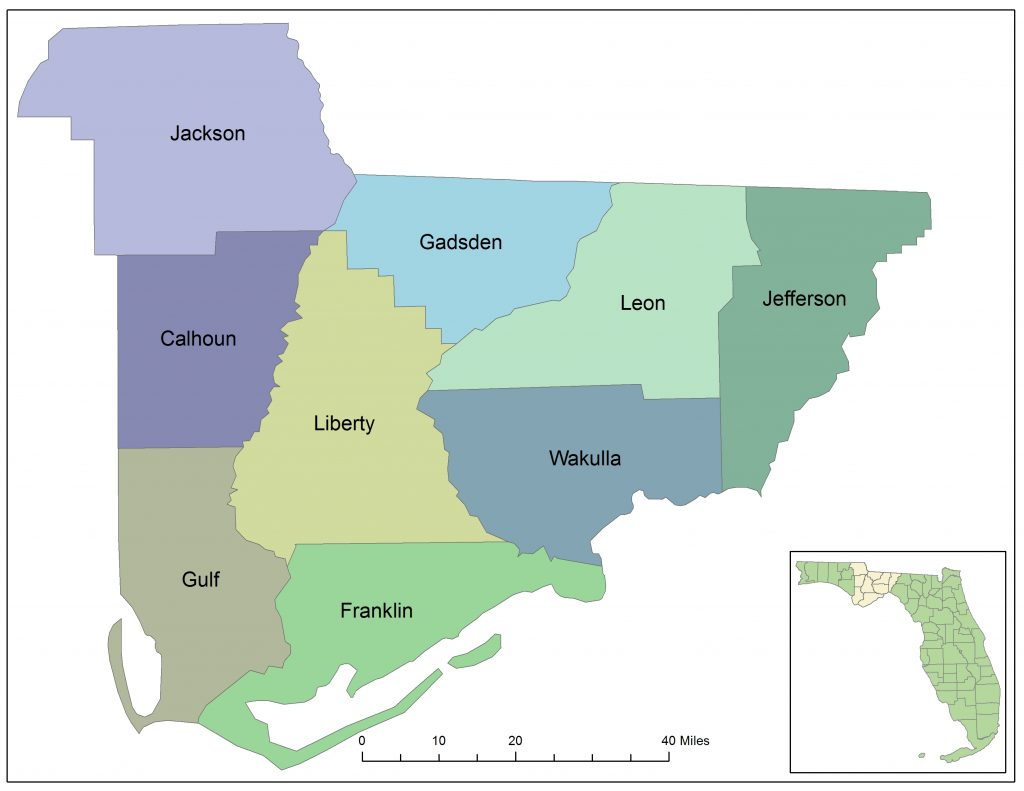
Volunteer Bill Bishop of New Jersey was selected to provide expertise to The
Apalachee Regional Planning Council (ARPC)
in the Apalachee region of northwest Florida as they conduct a housing needs assessment. This study is necessary to determine the extent and scope of damage to housing caused by Hurricane Michael, which devastated parts of the Florida panhandle in 2018, including most of the historically underfunded region served by the ARPC.
Read more about this project
here
.
Volunteer Helping to Map and Preserve Oak Woodlands for California Non-profit

River Ridge Institute
is a nonprofit dedicated to educating ranchers, policy-makers, and the public about the importance of preserving oak woodlands in California's Sierra Nevada foothills through sustainable land management and natural resource conservation. GISCorps volunteer Olivia Hughes of California was selected to
help River Ridge Institute with data integration, mapping, and the production of attractive materials to use in their presentations.
Read more about this project
here
.
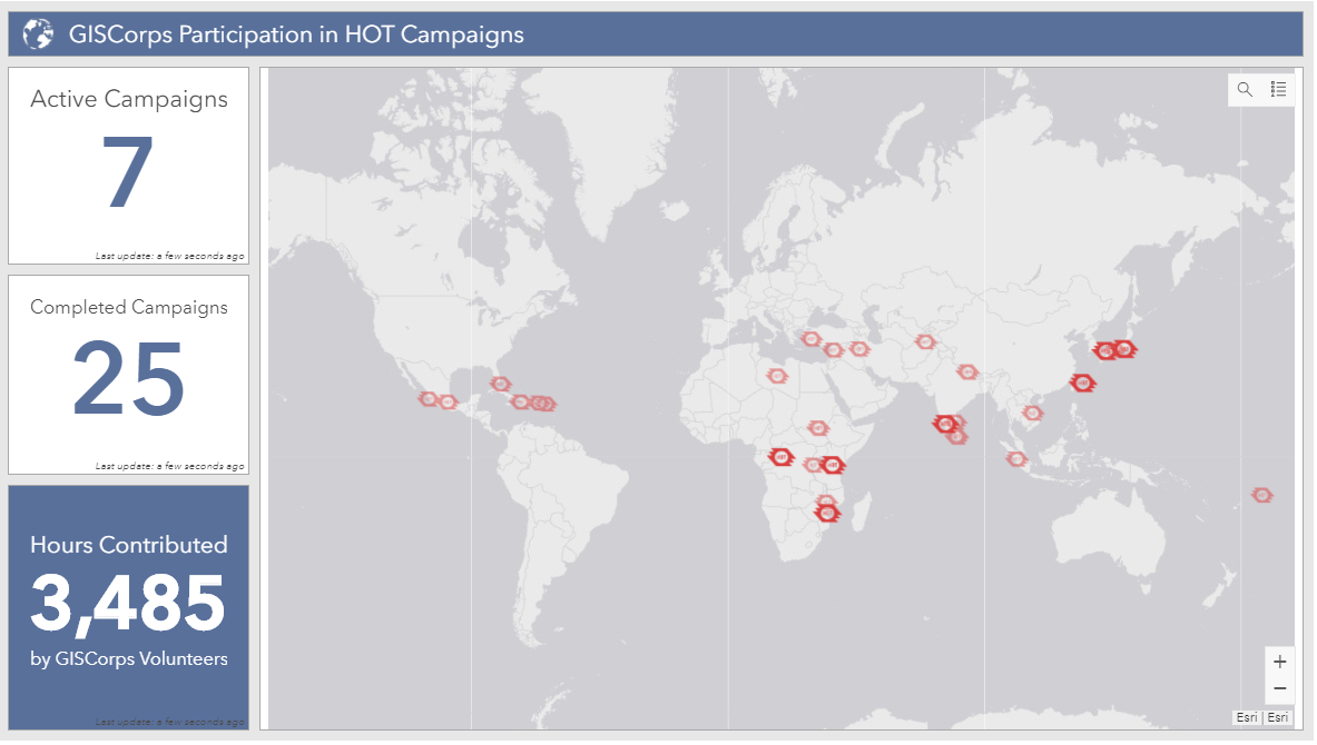
HOTOSM Projects
Humanitarian OpenStreetMap Team (HOT) continues to request support from GISCorps volunteers for urgent projects that have unmet demand for highly skilled OpenStreetMap editors. Since 2011, at least
204 GISCorps volunteers have contributed over
2,100 hours mapping and validating
24 HOT campaigns. Efforts are ongoing for the following HOT projects:
If you are already a GISCorps volunteer and a HOTOSM contributor, please remember to add #GISCorps to your changeset comments when you save your edits and don't forget to keep track of the hours you spend mapping. When you're finished, fill out this Google form so we can accurately track and report GISCorps volunteer contributions to HOTOSM projects. You'll also receive documentation of your contribution, which can be used for GISP credit.
|
|
The
GIS Service Pledge (GSP)
is a collaboration between Esri, URISA's GISCorps, and YOU! Invent your own GISCorps mission to support organizations or causes that would benefit from GIS expertise, applications, or analyses. Esri generously provides one-year ArcGIS personal use licenses that volunteers can use to make a difference in their own communities or across the world.
43 GIS Service Pledge applications submitted by volunteers from
seven
different countries have been approved. As participants wrap up their projects, we delight in reading their reports and learning how they were able to contribute to organizations they care about. You can read them, too, on this page of our website, which is dedicated to GIS Service Pledge project reports. You can also see where GSP participants are making a difference on this web map including this
recent highlight:
- Patrick R. Hall supported the Los Angeles Fire Department by mapping the locations of local Community Emergency Response Team (CERT) volunteers.
Do you know of a nonprofit organization that could benefit from your GIS expertise? Review the GIS Service Pledge guidelines and apply for the program
here
.
Send any questions specific to the GIS Service Pledge to [email protected]. And if you are a GISCorps volunteer who has identified a worthwhile GIS Service Pledge project idea, but would prefer to work within the supportive structure of a formal GISCorps mission, we'd love to hear about your idea too! In many cases, you can encourage the organization you'd like to help to request GISCorps support, and GISCorps can then launch a new project with you as the volunteer, bypassing the recruitment process.
|
| Conference News & Announcements |
GIS-Pro 2019 Recap
URISA's annual GIS-Pro conference was held September 28 - October 2 in New Orleans, Louisiana. GIS professionals from 42 states (plus Puerto Rico and the District of Columbia), 7 Canadian provinces, and 7 countries met to learn from keynote speakers and panelists and to exchange ideas in workshops and breakout sessions.
Best of all (from our perspective), GIS-Pro participants raised nearly $3,000 in a silent auction to support GISCorps operations and missions! The conference also hosted another GIS-Pro OpenStreetMap Mapathon!
If you missed this year's event (or if you want to relive it!), be sure to check out the GIS-Pro 2019 conference overview and the detailed event program available in the current edition of The GIS Professional.
And it's not too early to mark your calendar for GIS-Pro 2020 in Baltimore, Maryland September 27 - October 1.
|
|
Name:
Dacey Zelman-Fahm
Organization:
NAPSG Foundation
GISCorps mission(s)/Year served:
Hurricane Florence - 2018; Hurricane Michael - 2018; Hurricane Barry - 2019; Hurricane Dorian - 2019
Share your experiences about the missions:
Working with GISCorps on the hurricane story mapping missions has been an incredible adventure. As part of the Admin Team, we were tasked with assessing and evolving the crowdsource applications for usability, while contributing and vetting storm imagery. The experience provided the opportunity to work outside the confines of my typical projects, meet other GISers, and acquire new skills along the way. As an unexpected bonus, I have learned heaps about meteorology, emergency preparedness, and disaster relief as well!
Anything else to share:
Mapping disaster is a humbling experience and I am grateful and proud to be part of this positive crowdsource community.
For more volunteer profiles, visit the Our Volunteers page of our website.
|
| Thank you for your continued support of URISA's GISCorps! |
|
|
 |
|
Support GISCorps with a tax-deductible donation on Giving Tuesday. Your support is greatly appreciated!
|
2020 URISA Professional
Education Calendar
|
For more information, click here.
|
| Social Media |
|
If you haven't already, please join us on social media:
Facebook page Facebook group Twitter account LinkedIn page LinkedIn group Instagram Slack workspace
If you'd like to help us get the word out, please check out the
resources on
our website
. Also, please double check that the 'giscorps.org' domain is not being sent to your Spam folder.
|
| URISA's GISCorps Core Committee |
| Shoreh Elhami Dianne Haley Konrad Hughes Allen Ibaugh Carol Kraemer Wincy Poon German Whitley Troy Wirth Chris Zumwalt GIS/Administrative Assistant: Holly Torpey Contact us: www.giscorps.org Email: [email protected] |
|
|
|