Dear Florida Climate Center friends,
We'd like to present you with the September/October 2017 edition of our newsletter. In this newsletter, you'll find our August and September 2017 monthly climate summaries, outlooks on ENSO and the upcoming winter, and a round-up of staff outreach activities. If you have any questions, please send us an e-mail message at climate@coaps.fsu.edu.
Thanks,
The Staff of the Florida Climate Center
 |
 |
David Zierden
State Climatologist |
Danny Brouillette
Service Climatologist |
|
August and September Climate Summaries for Florida
The Florida Climate Center's
August 2017 Florida Climate Summary and
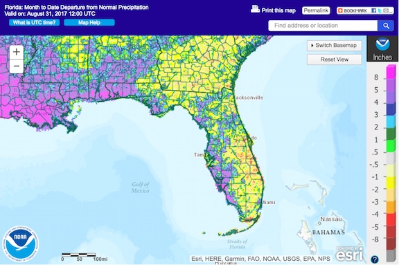
September 2017 Florida Climate Summary are now available. The monthly summary provides an analysis of temperature and precipitation patterns during the past month across the state, along with data on hazardous weather, drought, the impacts of the weather, and any records tied or broken for the month. During August, temperatures were well above the historical median statewide, averaging 82.6 degrees Fahrenheit and ranking 13th highest on record since 1895. The statewide-averaged rainfall total was above the historical median, coming in at 8.35", making for the 26th-wettest August on record. During September, temperatures were above the historical median, averaging 80.2 degrees Fahrenheit and ranking 23rd highest on record since 1895.
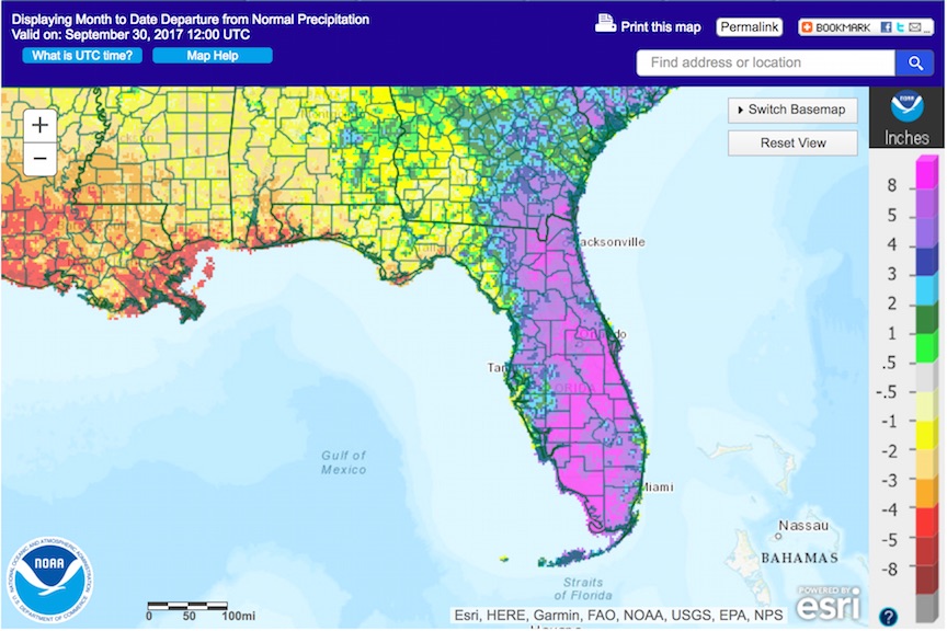
This ranking was again at or above the median of the historical record for the 21st consecutive month, continuing a record-long streak. The statewide-averaged rainfall total was above the historical median at 8.56", 21st highest in the instrumental record. Neutral ENSO conditions continue in the equatorial Pacific Ocean, and the outlook for winter favors the development of La Nina conditions, with some continued uncertainty; more details are given later in the newsletter. Drought is absent from Florida. Through the balance of October and into November, the
NOAA Climate Prediction Center outlooks Florida for equal chances of temperatures and increased chances of below-normal rainfall.
The following table gives August average temperatures and departures from normal (˚F) for selected cities.
| Station |
Average Temperature |
Departure from Normal |
| Pensacola |
83.9 |
+2.0 |
| Tallahassee |
82.7 |
+0.9 |
| Jacksonville |
82.4 |
+0.6 |
| Gainesville |
81.7 |
+0.8 |
| Orlando |
83.1 |
+0.3 |
| Tampa |
84.9 |
+1.9 |
| West Palm Beach |
84.7 |
+1.7 |
| Miami |
85.7 |
+1.5 |
| Key West |
85.8 |
+1.3 |
The following table gives August precipitation totals and departures from normal (inches) for selected cities.
| Station |
Total Rainfall
|
Departure from Normal |
| Pensacola |
19.35 |
+12.78 |
| Tallahassee |
7.52 |
+0.22 |
| Jacksonville |
9.09 |
+2.29 |
| Gainesville |
5.79 |
-0.60 |
| Orlando |
5.99 |
-1.14 |
| Tampa |
10.71 |
+3.19 |
| West Palm Beach |
5.72 |
-2.23 |
| Miami |
8.57 |
+0.01 |
| Key West |
2.23
|
-3.15 |
The following table gives September average temperatures and departures from normal (˚F) for selected cities.
| Station |
Average Temperature |
Departure from Normal |
| Pensacola |
80.4 |
+1.8 |
| Tallahassee |
78.7 |
+0.5 |
| Jacksonville |
79.0 |
+0.8 |
| Gainesville |
78.3 |
+0.1 |
| Orlando |
81.0 |
-0.1 |
| Tampa |
83.4 |
+1.7 |
| West Palm Beach |
83.4 |
+1.6 |
| Miami |
84.8 |
+1.9 |
| Key West |
84.6 |
+1.4 |
The following table gives September precipitation totals and departures from normal (inches) for selected cities.
| Station |
Total Rainfall |
Departure from Normal |
| Pensacola |
2.99 |
-2.81 |
| Tallahassee |
3.43 |
-1.26 |
| Jacksonville |
13.33 |
+5.14 |
| Gainesville |
15.28 |
+10.86 |
| Orlando |
14.09 |
+8.03 |
| Tampa |
6.66 |
+0.36 |
| West Palm Beach |
5.78 |
-2.57 |
| Miami |
14.97 |
+5.11 |
| Key West |
9.28 |
+2.57 |
The following schematics map August and September precipitation departures from normal, respectively, across Florida. Images courtesy of the National Weather Service.
|
|
Florida Climate Institute Hosts Climate Change Panel
The Florida Climate Institute presented a panel discussion on the campus of the Florida State University entitled "Climate Change and You" on 26 September. The discussion was moderated by Dr. Vasu Misra, and the panel included Dr. Eric Chassignet, Dr. James Elsner, State Climatologist David Zierden, Dr. Chris Uejio, Dr. Jeff Chanton, and Dr. Lori Medders. Zierden (pictured below) spoke briefly about climate-change communication and participated in a lively discussion with over 100 students.

|
|
Hurricane Irma Plowed Through Florida in September
|
|
| Irma approaching Florida. Courtesy: NASA/NOAA. |
On 10 September, Hurricane Irma made landfall as a Category 4 storm on Cudjoe Key, Monroe County, making it the first landfalling major hurricane in Florida since Hurricane Wilma made landfall on 24 October 2005. After making its initial landfall, its center tracked near and along the southwestern coast through the Naples and Fort Myers areas, before moving inland to near the middle peninsula, where it tracked north-northwestward. On the morning of the 11th, Irma's center tracked through the eastern Big Bend out of Florida into Georgia.
|
|
Irma's track. Courtesy: Weather Underground.
|
Irma had a significant impact on the state. Over the week before it hit Florida, it prompted an evacuation that snarled up traffic on highways throughout the region, causing gasoline shortages. Shortages of bottled water and some other supplies plagued population centers such as Tallahassee, as residents made hasty preparations, reinforcing the need for planning for hurricanes well in advance. The storm itself brought heavy rains of 10 to 25 inches along and east of its center, over a wide swath of the peninsula. Hurricane-force wind gusts were observed south and east of a line from Jacksonville to Gainesville to Pasco County, with the most powerful gusts along the southwest coast and in the Keys, where wind damage was significant. Several tornadoes were reported in the eastern part of the peninsula north of its midpoint. Storm surge reached record levels at some locations, including Jacksonville, along the northeast coast. More details are given in the September climate
summary. A more detailed special report will be released at a later date.
|
|
Florida Climate Center and COAPS Hosts Area Farmers and Extension
The Tri-State Working Group for Row Crop Farmers held their bi-annual get together on 25 September
at FSU's Center for Ocean-Atmospheric Prediction Studies. The group of farmers, Extension, and University researchers has been meeting since 2009 to promote the effective use of climate information in sustainable farming practices. After a discussion session on climate and weather impacts during this growing season, David Zierden presented a summary of climate and weather over the last season and the outlook for the fall and winter. Service Climatologist Danny Brouillette then presented on climate change impacts on extreme weather and potential changes in the future.
|
|
Current Outlook Favors La Nina Conditions this Winter
NOAA's Climate Prediction Center is currently running a La Nina Watch. Its outlook for the winter favors the development of a La Nina, the negative phase of the El Nino-Southern Oscillation (ENSO), during the upcoming winter, giving that event a 55-65% probability. At this time, with some week-to-week fluctuations in sea-surface-temperature (SST) anomaly, ENSO-neutral conditions are in place in the equatorial Pacific Ocean. However, the overall trend has been toward more negative SST anomalies.
|
|
| SST anomalies in the equatorial Pacific Ocean as a function of time and location. Courtesy: NOAA. |
|
|
|
Probability, as a function of time period, of El Nino, neutral, and La Nina ENSO conditions. Courtesy: IRI, NOAA.
|
Ensemble modelling suggests that, if a La Nina event did occur, it would be weak.
|
|
|
Ensemble of model projections of ENSO phase as a function of time period.
Courtesy: IRI, NOAA.
In Florida, La Nina events are associated with warmer- and drier-than-normal conditions during winter.
|
|
|
Warmer- and Drier-Than-Normal Winter Most Likely in Florida
Recently, NOAA's Climate Prediction Center issued a three-month outlook that covers the balance of climatological fall and the first two-thirds of climatological winter. It shows a heightened probability of warmer- and drier-than-normal conditions for all of Florida. Outlooks for farther ahead toward February and March show similar probabilities.
 A forecast of persistence (i.e., continuation of a string of warmer-than-normal winters) and the heightened probability of La Nina conditions this winter are the two main sources of forecast reasoning. A forecast of persistence (i.e., continuation of a string of warmer-than-normal winters) and the heightened probability of La Nina conditions this winter are the two main sources of forecast reasoning.
|
|
Florida Climate Center in the News
|
| About Us The Florida Climate Center is part of a three-tiered system of national, regional, and state climate offices, including NOAA's National Centers for Environmental Information (NCEI - in Asheville, North Carolina) and the Southeast Regional Climate Center (in Chapel Hill, North Carolina). The Florida State Climatologist and other staff at the Florida Climate Center provide the following information and services to the people of Florida:
· Climate Data: Historical weather observations for weather stations throughout the state of Florida. We are able to provide data for most stations from 1948-present.
· Climate Information: Long-term historical averages for various stations, climate divisions, and the entire state.
· Extreme Event Records: Information and analyses on extreme events such as freezes, droughts, floods and hurricanes.
· Special Analysis: With their vast knowledge of El Niño, La Niña and climate variability, the State Climatologist and staff can offer expert insight into Florida's climate trends.
· Outreach: Activities, presentations, and workshops that inform and educate the people of Florida about current and emerging climate issues. We also coordinate volunteers for the Community Collaborative Rain, Hail & Snow Network (CoCoRaHS).
More About Us |
|


