|
|
22nd ANNUAL GEODETIC PICNIC
Innovations in Geodesy Expo
Friday, September 22, 2017
9:00 am - 3:00 pm
(Coffee and Name Tag Pick-up - 8:15 am)
Nottawasaga Inn Resort and Conference Centre
6015 Highway 89, Alliston, ON L9R 1A4
The Geodetic Picnic Program:
Morning Session:
9:00 am - 12:00 pm
Morning Session Topics:
- "Then and Now: Forty Years of GPS" - Pierre Heroux, NRCan
- Building Information Modelling - "From Scan to BIM" - Roland Mangold, BIMRAY
- "Ontario's Imagery and Elevation Data Holdings" - Land Information Ontario
- ...and more - Stay tuned!
Afternoon Exhibitor Session and Other Demonstrations:
1:30 - 3:00 pm
Morning coffee as well as lunch are included in the registration cost, and will be served on site.
BBQ is the order of the day!
Mark your calendars and be there to collect
3 Formal CPD hours
!
The morning sessions will be in the Crystal ballroom and will be followed by BBQ Lunch and time with exhibitors. It will be a great day!
Stay tuned for more info to come...
Online Registration for the 2017 Geodetic Picnic is already open!
Register at:
|
Public Awareness Committee (PAC) Update
|
This issue of In Sight contains an update from our Public Awareness Committee (PAC).
The Public Awareness Committee (PAC) had its budget and tactical plan approved at the annual meeting in February. The plan has three objectives for 2017:
- Manage the AOLS brand that embodies the competence and expertise of its members through the office and resources of the Association of Ontario Land Surveyors.
- Develop and implement an Integrated Marketing Communications Plan (IMC) to reinforce public awareness of the geomatics/surveying profession in Ontario.
- Assist Council and members to advocate for professional geomatics/surveying services and products, and create public awareness of AOLS issues that impact the growth of the AOLS and long-term need for the services and products of its members.
To date, the PAC has worked closely with the Geomatics Recruitment and Liaison Committee (GRLC) to produce a
video promoting the profession through the Specialist High Skills Major in Construction at high schools.
PAC Members currently are:
Michael Matthews (Chair),
Cindy Kliaman,
David Lamont,
Simon Kasprzak,
Sasa Krcmar,
Brian Kerr,
Bob Pearson,
Bob McDermott,
Eric Ting,
Rudy Mak,
Maureen Mountjoy (Staff),
Natalie Vibert (Articling Student),
Grant Lee (Consultant).
 |
Image (click on it to see in full size):
Flyer created by PAC and distributed at Science Rendezvous (Canada's largest showcase of STEM - Science, Technology, Engineering and Mathematics) as part of the hand out package for the first 600 families.
The flyer
was also included in the digital workbook available here (page 48).
|
|
Applications for Articles
|
Please note: candidates wishing to article must submit the completed forms to the Association of Ontario Land Surveyors by no later than Friday, August 18, 2017.
Do not hesitate to contact Lena Kassabian, AOLS Office Manager if you have any questions or concerns: [email protected]
|
Bruce County Heritage Documentary Project
|
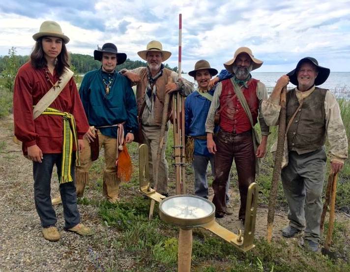
Earlier this summer, our office got contacted by
Yvonne Drebert, the producer of the Bruce County Heritage Documentary Project, a 3x50min documentary series on the history of Bruce County and the Saugeen Ojibway Territory to be broadcast on TVO. Yvonne mentioned that they had borrowed some artifacts from us a few years ago for a project called "The Land Between", and was wondering whether they could borrow some more for an 1850s surveying re-enactment on July 9th in Bruce County.
Mr. Brent England, OLS generously agreed to lend his artifacts for this project.
Says Brent,
"They borrowed an "older looking" tripod from us and I think from the photographs that it worked for their purposes. I also provided Yvonne with our copy of "Crown Surveys in Ontario" published by the Department of Lands and Forests in 1962 to give her an idea of the work we used to do on Crown Surveys and the original Township surveys.
As you can see from the photographs, they had two antique survey instruments to use in their re-enactment and it looked like they did a good job or re-creating a survey crew."
The documentary component of the project will be distributed for free, along with a curriculum companion book, into every school in Bruce County. To launch the series, free screenings will be held in locations throughout Bruce County in late 2017 and 2018.
|
News from Our Suppliers:
MicroSurvey CAD 2017
|
Press Release from MicroSurvey Software Inc.:
"
MicroSurvey Software Inc. is proud to announce the release of MicroSurvey CAD 2017 with powerful new and enhanced capabilities, streamlined workflows, and important bug fixes that continue to make MicroSurvey CAD the absolute best choice for land surveying and civil engineering professionals worldwide.
MicroSurvey CAD provides users with an intuitive interface on a complete survey drafting toolkit, including COGO, DTM, traversing, adjustments, volumes, contouring and more. MicroSurvey CAD is perpetually licensed and is powered by IntelliCAD® which is compatible with AutoCAD® drawing files. With five available feature levels - Basic, Standard, Premium, Ultimate and Studio - MicroSurvey CAD gives users the choice between several tiers of features to ensure they are getting precisely the tools they need.
|
| Do you have suggestions for the AOLS In Sight content? If you have come across some information that you think will be of interest to other members, please let us know by emailing [email protected]. Your suggestions are always welcome!    
|
|
|
|
Upcoming Events
|
South Central Regional Group
Friday, August 25
Eastern Regional Group Meeting
Tuesday,
September 12
|
|
AOLS in Social Media
|
|
The AOLS Group on LinkedIn has over
540 members
!
Join up to network with peers, students and recruiters:
"Like" the AOLS page and follow us on Facebook:

Follow us on Twitter:
Subscribe to our channel on YouTube:
|
|
Donate to the
Educational Foundation
|
Donate to the Educational Foundation online!
|
|
In Sight Archive
|
AOLS In Sight Archive is available on our website: just go to the News section, then browse or search newsletter issues starting from the very first issue of November 2011.
|
|
Other Organizations' Newsletters
|
|
Four Point Learning:
Case Commentaries on Property Title and Boundary Law
Professional Surveyors Canada:
Click here
for the archives page for the latest Horizon and e-communiqué.
Stay informed about what is happening in your national surveyor community!
Click on the logo to go to the PSC website:
|
|
|