Dear Florida Climate Center friends,
We'd like to present you with the May 2017 edition of our newsletter. In this newsletter, you'll find our April 2017 monthly climate summary, a brief about the ongoing drought and wildfire season in Florida, information about the imminent 2017 North Atlantic hurricane season, and more. If you have any questions, please send us an e-mail message at climate@coaps.fsu.edu.
Thanks,
The Staff of the Florida Climate Center
 |
 |
David Zierden
State Climatologist |
Danny Brouillette
Service Climatologist |
|
April Climate Summary for Florida
The Florida Climate Center's
April 2017 Florida Climate Summary is now available. The summary provides an analysis of temperature and precipitation patterns during the past month across the state, along with data on hazardous weather, drought, the impacts of the weather, and any records tied or broken for the month. During April, temperatures were much above the historical median statewide, averaging 72.3 degrees Fahrenheit and ranking 11th highest on record since 1895. This ranking was again above the median of the historical record for the 14th consecutive month, continuing a record-long streak. The statewide-averaged rainfall total was near the historical median, coming in at 2.43", making for the 50th-driest April on record. Neutral ENSO conditions continue in the equatorial Pacific Ocean, and the outlook for summer and beyond remains somewhat uncertain, with approximately equal chances of neutral conditions or the start of an El Ni
ño event. Drought, severe to extreme in some areas, is affecting much of the state, and an update is provided about this situation later in the newsletter. Through the balance of May and into early June, the
NOAA Climate Prediction Center outlooks Florida for increased chances of above-normal temperatures, especially once May ends, and equal chances of below- near-, or above-normal rainfall over most of the state and an increased probability of above-normal rainfall over the western half of the panhandle.
The following table gives April average temperatures and departures from normal (˚F) for selected cities.
| Station |
Average Temperature |
Departure from Normal |
| Pensacola |
71.5 |
+4.9 |
| Tallahassee |
69.8 |
+3.7 |
| Jacksonville |
70.0 |
+2.9 |
| Gainesville |
70.2 |
+2.6 |
| Orlando |
74.4 |
+3.2 |
| Tampa |
77.1 |
+5.1 |
| West Palm Beach |
76.1 |
+2.3 |
| Miami |
78.0 |
+2.2 |
| Key West |
77.6 |
+1.1 |
The following table gives April precipitation totals and departures from normal (inches) for selected cities.
| Station |
Total Rainfall
|
Departure from Normal |
| Pensacola |
3.71 |
-0.61 |
| Tallahassee |
3.17 |
+0.11 |
| Jacksonville |
0.74 |
-1.90 |
| Gainesville |
2.74 |
+0.07 |
| Orlando |
trace |
-2.68 |
| Tampa |
0.59 |
-1.44 |
| West Palm Beach |
3.74 |
+0.08
|
| Miami |
2.16 |
-0.98 |
| Key West |
3.88
|
+1.88 |
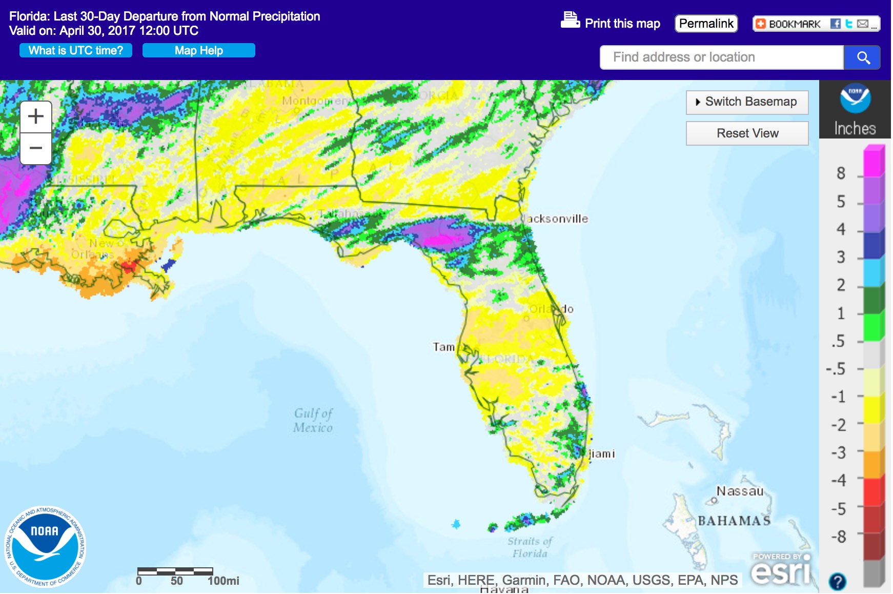
The following schematic maps April precipitation departures from normal across Florida. Image courtesy of the National Weather Service.
|
|
Numerous Wildfires Burn Amid Continuing Drought; Upcoming Summer Rainy Season Offers Should Offer Relief
Significant rainfall deficits, starting from early October, continue to mount in a large area of central and parts of south Florida and are beginning to be appreciable in parts of north Florida. In the most severely affected portions of central and southwest Florida, rainfall in the last six months has been only one-quarter of normal.

Correspondingly, drought has continued to worsen since last month over much of the state. Below is the latest issue of the US Drought Monitor.

Florida's spring wildfire season has continued at a more-active-than-usual pace. As of 18 May, according to the Florida Forest Service (FFS), statewide, nearly 108,000 acres had burned on lands under the purview of the FFS, and nearly 175,000 acres of federal lands had burned. As of that same date, 100 wildfires were active on FFS lands, 27 of them affecting over 100 acres, and three were active on federal lands. Arson is thought to be the direct cause of the the vast majority of the fires. Earlier in the spring, Governor Rick Scott issued an emergency declaration to expedite government response to wildfires. Additionally, the St. Johns River Water Management District and South Florida Water Management District issued orders for water conservation in fears of possible water shortages. Pictured below is the so-called West Mims wildfire, burning over 150,000 acres in the Okefenokee Swamp in northeast Florida and southeast Georgia.

|
|
2017 North Atlantic Hurricane Season to Begin on 1 June
|
|
| Hurricane Matthew bearing down on Florida's eastern coast in October 2016. |
On 1 June, the North Atlantic hurricane season will officially commence and continue until 30 November. The list of storm names for this season is as follows: Arlene, Bret, Cindy, Don, Emily, Franklin, Gert, Harvey, Irma, Jose, Katia, Lee, Maria, Nate, Ophelia, Philippe, Rina, Sean, Tammy, Vince, and Whitney.
Seasonal forecasts are calling for a less active season than last year's. One
outlook from a team at the Colorado State University calls for 11 named storms, of which four may become hurricanes and two may become major hurricanes (category three or greater on the Saffir-Simpson scale). By comparison, last year's season included 15 named storms of which seven became hurricanes and four became major hurricanes.
Even though a less active season is anticipated at this time, it is still very important for coastal residents to make preparations. The State of Florida's Division of Emergency Management provides pertinent information and advice on its Web
site. After all, this will be the big, memorable season for residents of any area that does get stricken by a hurricane.
|
|
Carrots and Climate
The Tri-State Climate Learning Network held its biannual meeting on 26 April in Bainbridge, Georgia, and carrot farming was the theme! Because of drought and the concerns about water availability, more and more carrot farming is being done in south Georgia and north Florida. The group, which included State Climatologist David Zierden, visited a processing facility run by Grimmway Farms and then went to Glenn Heard's farm to learn about his growing practices. The afternoon was spent discussing the advantages and challenges of growing carrots in this region versus California and how climate variability and change plays a part.
|
NASA Heat Vulnerability Project Meeting
State Climatologist David Zierden and Center for Ocean-Atmospheric Prediction Studies graduate student Jihoon Jung attended the annual project meeting for our NASA Roses project on heat vulnerability and human health in Albany, New York, on 4 and 5 May. The project aims to use high-resolution satellite temperature products from MODIS and the NLDAS surface temperature product to identify areas impacted by urban heat island effects and how that relates to vulnerable populations. Partners in the project include the New York State and New York City Departments of Health, USRA at the University of Alabama Huntsville, and the Florida Department of Health.
|
|
Florida Climate Center in the News
|
|
Upcoming Events
25 May: Suwannee River Educational Partnership meeting - Live Oak, Florida
28-30 June: American Association of State Climatologists Annual Meeting - Asheville, North Carolina
|
| About Us The Florida Climate Center is part of a three-tiered system of national, regional, and state climate offices, including NOAA's National Centers for Environmental Information (NCEI - in Asheville, North Carolina) and the Southeast Regional Climate Center (in Chapel Hill, North Carolina). The Florida State Climatologist and other staff at the Florida Climate Center provide the following information and services to the people of Florida:
· Climate Data: Historical weather observations for weather stations throughout the state of Florida. We are able to provide data for most stations from 1948-present.
· Climate Information: Long-term historical averages for various stations, climate divisions, and the entire state.
· Extreme Event Records: Information and analyses on extreme events such as freezes, droughts, floods and hurricanes.
· Special Analysis: With their vast knowledge of El Niño, La Niña and climate variability, the State Climatologist and staff can offer expert insight into Florida's climate trends.
· Outreach: Activities, presentations, and workshops that inform and educate the people of Florida about current and emerging climate issues. We also coordinate volunteers for the Community Collaborative Rain, Hail & Snow Network (CoCoRaHS).
More About Us |
|


