Dear Florida Climate Center friends,
We'd like to present you with the November/December 2017 edition of our newsletter. In this newsletter, you'll find our October and November 2017 monthly climate summaries, an update on the La Nina event underway as well as the current winter outlook, information about our special report on Hurricane Irma, and a round-up of staff outreach activities. If you have any questions, please send us an e-mail message at climate@coaps.fsu.edu.
Thanks,
The Staff of the Florida Climate Center
 |
 |
David Zierden
State Climatologist |
Danny Brouillette
Service Climatologist |
|
October and November Climate Summaries for Florida
The Florida Climate Center's
October 2017 Florida Climate Summary and
November 2017 Florida Climate Summary are now available. The monthly summary provides an analysis of temperature and precipitation patterns during the past month across the state, along with data on hazardous weather, drought, the impacts of the weather, and any records tied or broken for the month. During October, temperatures were well above the historical median statewide, averaging 74.8 degrees Fahrenheit and ranking 14th highest on record since 1895. The statewide-averaged rainfall total was above the historical median, coming in at 5.17", making for the 26th-wettest August on record. During November, temperatures were above the historical median, averaging 67.3 degrees Fahrenheit and ranking 18th highest on record since 1895.
This ranking was again at or above the median of the historical record for the 23rd consecutive month (and above the normal for the 21st), continuing a record-long streak. The statewide-averaged rainfall total was just below the historical median at 1.63", 48th lowest in the instrumental record. La Nina (ENSO-negative) conditions are now being observed in the equatorial Pacific Ocean. According to the most recent US Drought Monitor, moderate drought conditions are in place in the central portion of the panhandle, with abnormally dry conditions over the balance of the panhandle and over the far northwestern portion of the peninsula. More details about both ENSO and drought are given later in the newsletter. Through the balance of December, the
NOAA Climate Prediction Center outlooks Florida for an enhanced probability of below-normal temperatures and equal chances of below-, near-, and above-normal rainfall.
The following table gives October average temperatures and departures from normal (˚F) for selected cities.
| Station |
Average Temperature |
Departure from Normal |
| Pensacola |
73.5 |
+3.9 |
| Tallahassee |
72.8 |
+3.4 |
| Jacksonville |
74.0 |
+3.6 |
| Gainesville |
72.0 |
+1.1 |
| Orlando |
75.7 |
0.0 |
| Tampa |
78.2 |
+2.0 |
| West Palm Beach |
78.7 |
+0.4 |
| Miami |
80.8 |
+0.9 |
| Key West |
80.8 |
+0.6 |
The following table gives October precipitation totals and departures from normal (inches) for selected cities.
| Station |
Total Rainfall
|
Departure from Normal |
| Pensacola |
10.30 |
+5.06 |
| Tallahassee |
3.97 |
+0.74 |
| Jacksonville |
4.01 |
+0.08 |
| Gainesville |
1.57 |
-1.31 |
| Orlando |
3.59 |
+0.28 |
| Tampa |
3.07 |
+0.81 |
| West Palm Beach |
15.02 |
+5.13 |
| Miami |
12.61 |
+6.28 |
| Key West |
5.81
|
+0.88 |
The following table gives November average temperatures and departures from normal (˚F) for selected cities.
| Station |
Average Temperature |
Departure from Normal |
| Pensacola |
61.6 |
+2.0 |
| Tallahassee |
62.1 |
+1.9 |
| Jacksonville |
65.1 |
+2.9 |
| Gainesville |
63.5 |
+0.7 |
| Orlando |
69.9 |
+1.4 |
| Tampa |
72.1 |
+3.0 |
| West Palm Beach |
75.4 |
+2.6 |
| Miami |
77.3 |
+2.4 |
| Key West |
77.4 |
+1.5 |
The following table gives November precipitation totals and departures from normal (inches) for selected cities.
| Station |
Total Rainfall |
Departure from Normal |
| Pensacola |
0.48 |
-4.65 |
| Tallahassee |
0.53 |
-2.97 |
| Jacksonville |
2.61 |
+0.50 |
| Gainesville |
2.76 |
+0.70 |
| Orlando |
0.17 |
-2.00 |
| Tampa |
0.12 |
-1.43 |
| West Palm Beach |
2.69 |
-2.06 |
| Miami |
4.41 |
+1.14 |
| Key West |
1.51 |
-0.79 |
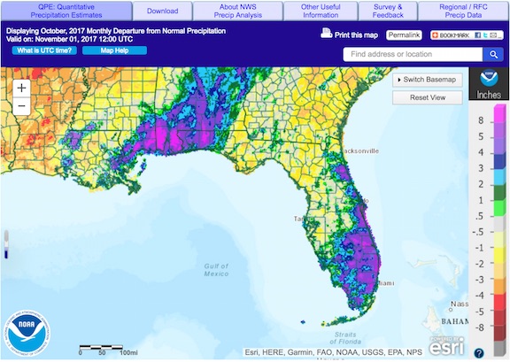
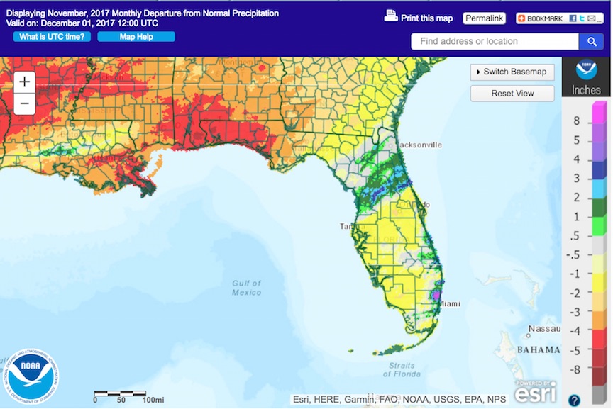
The following schematics map October and November precipitation departures from normal, respectively, across Florida. Images courtesy of the National Weather Service.
|
|
Florida Climate Center Participates in STEM Festival

The sixth-annual Tallahassee Science Festival was held at Kleman Plaza in downtown Tallahassee on 28 October. Drawing over 5000 spectators this year, the event brings together representatives from a wide range of organizations involved with science, technology, engineering, and mathematics, as well as the arts, and they present interactive exhibits. Over 130 organizations from Tallahassee and the surrounding region participated this year, making this iteration of the festival the largest yet. In cooperation with the FSU Thalassic Society, the COAPS exhibit engaged spectators in demonstrations involving making a cloud inside a liter-sized bottle and showing the difference in the densities of salt water and fresh water. As well, a standard rain gauge and hail-collection pad were available for examination, and information was provided about Florida Climate Center's and COAPS' wide range of research and service activities. Led by Danny Brouillette, service climatologist with the Florida Climate Center and COAPS, the team included Lydia Stefanova and Alan Wallcraft from COAPS and Jason Ducker and Fred Soster from the Thalassic Society.
|
|
Hurricane Irma Report Published
On 10 September, Hurricane Irma made landfall as a Category 4 storm on Cudjoe Key, Monroe County, making it the first landfalling major hurricane in Florida since Hurricane Wilma made landfall on 24 October 2005. In recognition of the large impact that Irma had on Florida and many other areas, the Florida Climate Center has published a comprehensive post-mortem report about the storm. It can be found on our Web site. This report is the latest in a series of special reports that seeks to document significant weather and climate events in a statewide context.
|
|
State Climatologist Participates in Enterprise Panel
State Climatologist David Zierden was part of a panel discussion on weather and climate services and opportunities for businesses and enterprise on 8 December in Tallahassee. The
8th Americas Competitiveness Exchange is a group of government officials from many different Central and South American countries touring six Florida cities
in 7 days.
|
|
Current La Nina Conditions Favor Warm, Dry Winter in Florida
NOAA's Climate Prediction Center currently has a La Nina Advisory mounted. This advisory reflects ENSO-negative conditions in the equatorial Pacific Ocean, meaning that negative SST anomalies have persisted there for a sustained period of time. The image below shows the average of the SST anomalies in this region over the last four weeks.
Hints from ensemble modelling and other tools still hint at a relatively weak La Nina event, overall, and that it will persist through the winter before fading in the early spring, as shown in the probabilistic forecast below.
The Climate Prediction Center still has all of Florida outlooked for a likelihood of drier- and warmer-than-normal conditions, on average, through March 2018.
|
|
State Climatologist Participates in Irrigation Workshop
The Wiregrass Research and Education Center hosted an irrigation workshop in Dothan, Alabama, on 7 December. State Climatologist David Zierden attended the workshop and presented on recent temperature and rainfall patterns, the La Nina pattern present in the Pacific Ocean, and the seasonal outlook for the winter and spring seasons in southeast Alabama and north Florida.
|
|
State Climatologist Presents to Rotary Club
State Climatologist David Zierden was the guest speaker at the 29 November meeting of Tallahassee Rotary, representing the Florida Climate Center and COAPS. He was introduced by Rotarian Ruth Pryor, former long-time projects manager at COAPS.
|
|
Florida Climate Center in the News
|
| About Us The Florida Climate Center is part of a three-tiered system of national, regional, and state climate offices, including NOAA's National Centers for Environmental Information (NCEI - in Asheville, North Carolina) and the Southeast Regional Climate Center (in Chapel Hill, North Carolina). The Florida State Climatologist and other staff at the Florida Climate Center provide the following information and services to the people of Florida:
· Climate Data: Historical weather observations for weather stations throughout the state of Florida. We are able to provide data for most stations from 1948-present.
· Climate Information: Long-term historical averages for various stations, climate divisions, and the entire state.
· Extreme Event Records: Information and analyses on extreme events such as freezes, droughts, floods and hurricanes.
· Special Analysis: With their vast knowledge of El Niño, La Niña and climate variability, the State Climatologist and staff can offer expert insight into Florida's climate trends.
· Outreach: Activities, presentations, and workshops that inform and educate the people of Florida about current and emerging climate issues. We also coordinate volunteers for the Community Collaborative Rain, Hail & Snow Network (CoCoRaHS).
More About Us |
|


